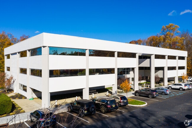
Property Record
Highway 35, Millstone Twp, NJ 07748


Save to a Folder
{{folder.Name}}
{{folder.ListingIds.length}} Properties
{{folder.ListingIds.length}} Property
Create a New Folder
Current Lease Availabilities
Property Detail
Highway 35
32-00607-0000-00014
MONMOUTH
Officecondo
New Jersey
MU15
10
B and X Area of moderate flood hazard, usually the area between the limits of the 100-year and 500-year floods.
0.03 AC
2025
Eastern Monmouth
2026
Northern New Jersey
800702
Lakewood-New Brunswick, NJ
7,084 SF
NEARBY LISTINGS FOR SALE OR LEASE
DEMOGRAPHICS near Highway 35
1 mile
3 mile
5 mile
2025 Total Population
7,146
65,600
128,847
2030 Population
7,141
65,124
127,996
Pop Growth 2025-2030
(0.07%)
(0.73%)
(0.66%)
Average Age
43
42
42
2025 Total Households
2,517
23,483
47,385
HH Growth 2025-2030
(0.32%)
(0.91%)
(0.85%)
Median Household Inc
$126,865
$125,249
$123,655
Avg Household Size
2.70
2.70
2.60
2025 Avg HH Vehicles
2.00
2.00
2.00
Median Home Value
$671,619
$576,553
$595,780
Median Year Built
1972
1968
1968
Nearby Places
Map Layers
Map Styles
 Street
 Aerial
Layers
 Traffic
 Biking
Places
Listings with unknown addresses are not visible on the map
- Restaurants
- Banks
- Shops
- Fitness
- Groceries
PUBLIC TRANSPORTATION
COMMUTER RAIL
Middletown Nj (North Jersey Coast Line - NJ TRANSIT RAIL)
Drive
Walk
Distance
Middletown Nj (North Jersey Coast Line - NJ TRANSIT RAIL)
6 min
3.2 mi
Hazlet (North Jersey Coast Line - NJ TRANSIT RAIL)
Drive
Walk
Distance
Hazlet (North Jersey Coast Line - NJ TRANSIT RAIL)
6 min
4.4 mi
AIRPORT
Newark Liberty International
Drive
Walk
Distance
Newark Liberty International
43 min
32.0 mi
LaGuardia
Drive
Walk
Distance
LaGuardia
72 min
49.3 mi
Freight Ports
New York Container Terminal
Drive
Walk
Distance
New York Container Terminal
36 min
27.1 mi
Nearby Properties
Address
Land Use
TOTAL SIZE
Lot Size
Zoning
Address
Land Use
TOTAL SIZE
Lot Size
Zoning
838,137 SF
253 AC
R45
Address
Land Use
TOTAL SIZE
Lot Size
Zoning
596.51 AC
CONREC
Address
Land Use
TOTAL SIZE
Lot Size
Zoning
6,500 SF
48.71 AC
CI
Address
Land Use
TOTAL SIZE
Lot Size
Zoning
37.83 AC
PUD
Address
Land Use
TOTAL SIZE
Lot Size
Zoning
196,948 SF
19.80 AC
BH
Address
Land Use
TOTAL SIZE
Lot Size
Zoning
Address
Land Use
TOTAL SIZE
Lot Size
Zoning
10.44 AC
TMHO
Address
Land Use
TOTAL SIZE
Lot Size
Zoning
147,236 SF
20.01 AC
MU15
Address
Land Use
TOTAL SIZE
Lot Size
Zoning
231,505 SF
21.75 AC
MU15
Address
Land Use
TOTAL SIZE
Lot Size
Zoning
22.51 AC
MF08
Address
Land Use
TOTAL SIZE
Lot Size
Zoning
29.59 AC
CI
Address
Land Use
TOTAL SIZE
Lot Size
Zoning
1,685 SF
89.85 AC
MU15
Address
Land Use
TOTAL SIZE
Lot Size
Zoning
118,375 SF
18.20 AC
MU15
Address
Land Use
TOTAL SIZE
Lot Size
Zoning
133,184 SF
14.10 AC
MU15
Address
Land Use
TOTAL SIZE
Lot Size
Zoning
151,463 SF
20.58 AC
M-2
Address
Land Use
TOTAL SIZE
Lot Size
Zoning
3,641 SF
22.58 AC
C1
Address
Land Use
TOTAL SIZE
Lot Size
Zoning
1,242 SF
0.29 AC
P
Address
Land Use
TOTAL SIZE
Lot Size
Zoning
83,449 SF
0.57 AC
SF05
Address
Land Use
TOTAL SIZE
Lot Size
Zoning
237,821 SF
38.92 AC
SF20
Address
Land Use
TOTAL SIZE
Lot Size
Zoning
42,314 SF
52 AC
IA
Address
Land Use
TOTAL SIZE
Lot Size
Zoning
67,832 SF
10.46 AC
RGA
Address
Land Use
TOTAL SIZE
Lot Size
Zoning
127,410 SF
6.02 AC
MF15
Address
Land Use
TOTAL SIZE
Lot Size
Zoning
3,864 SF
260 AC
R15
Address
Land Use
TOTAL SIZE
Lot Size
Zoning
5 AC
PUD
Address
Land Use
TOTAL SIZE
Lot Size
Zoning
91,520 SF
21.37 AC
MF08
Address
Land Use
TOTAL SIZE
Lot Size
Zoning
117,594 SF
11.49 AC
MU15
Address
Land Use
TOTAL SIZE
Lot Size
Zoning
8,610 SF
169.16 AC
R30
Address
Land Use
TOTAL SIZE
Lot Size
Zoning
9,904 SF
135.45 AC
M-2
Address
Land Use
TOTAL SIZE
Lot Size
Zoning
141,313 SF
23.19 AC
SF20
Address
Land Use
TOTAL SIZE
Lot Size
Zoning
83,416 SF
44.01 AC
R22
The World's #1 Commercial Real Estate Marketplace
Connect with us
© 2026 CoStar Group
The information above has been obtained from sources believed reliable. While we do not doubt its accuracy we have not verified it and make no guarantee, warranty or representation about it. It is your responsibility to independently confirm its accuracy and completeness. Any projections, opinions, assumptions, or estimates used are for example only and do not represent the current or future performance of the property. The value of this transaction to you depends on tax and other factors which should be evaluated by your tax, financial, and legal advisors. You and your advisors should conduct a careful, independent investigation of the property to determine to your satisfaction the suitability of the property for your needs.