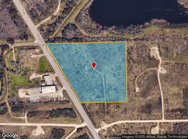
Property Record
Highway 35, Pearland, TX 77511

NEARBY LISTINGS FOR SALE OR LEASE
Property Detail
Highway 35
Houston-The Woodlands-Sugar Land, TX
H T & B R R
0292-0066-000
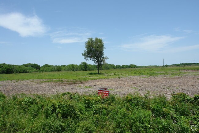
A0292 H T & B R R TRACT 25 (SURFACE ONLY) ACRES 10.14
Agriculturalland
Brazoria
AE
Texas
48039C0044K
10.14 AC
2024
NASA/Clear Lake
2025
Houston
661400
DEMOGRAPHICS near Highway 35
1 Mile
3 Mile
5 Mile
2024 Total Population
378
34,407
124,747
2029 Population
422
37,527
133,219
Pop Growth 2024-2029
+ 11.64%
+ 9.07%
+ 6.79%
Average Age
39
38
38
2024 Total Households
125
11,521
41,851
HH Growth 2024-2029
+ 11.20%
+ 9.15%
+ 6.94%
Median Household Inc
$85,119
$103,142
$105,484
Avg Household Size
2.80
2.90
2.90
2024 Avg HH Vehicles
2.00
2.00
2.00
Median Home Value
$421,250
$290,863
$286,585
Median Year Built
1991
1993
1995
Nearby Places
Map Layers
Map Styles
 Street
 Aerial
- Restaurants
- Banks
- Shops
- Fitness
- Groceries
PUBLIC TRANSPORTATION
AIRPORT
William P Hobby
DRIVE
WALK
Distance
William P Hobby
25 min
10.1 mi
George Bush Intcntl/Houston
DRIVE
WALK
Distance
George Bush Intcntl/Houston
55 min
42.7 mi
Nearby Properties
Address
Land Use
TOTAL SIZE
Lot Size
Zoning
Address
Land Use
TOTAL SIZE
Lot Size
Zoning
40.52 AC
0017
Address
Land Use
TOTAL SIZE
Lot Size
Zoning
83.37 AC
0004
Address
Land Use
TOTAL SIZE
Lot Size
Zoning
64.56 AC
0016
Address
Land Use
TOTAL SIZE
Lot Size
Zoning
236,642 SF
11.48 AC
Address
Land Use
TOTAL SIZE
Lot Size
Zoning
7.42 AC
Address
Land Use
TOTAL SIZE
Lot Size
Zoning
97,736 SF
16.49 AC
Address
Land Use
TOTAL SIZE
Lot Size
Zoning
142,155 SF
19.16 AC
SP
Address
Land Use
TOTAL SIZE
Lot Size
Zoning
161,803 SF
54.82 AC
Address
Land Use
TOTAL SIZE
Lot Size
Zoning
110,990 SF
18.25 AC
Address
Land Use
TOTAL SIZE
Lot Size
Zoning
113,376 SF
9.80 AC
Address
Land Use
TOTAL SIZE
Lot Size
Zoning
99,042 SF
13 AC
MFRM
Address
Land Use
TOTAL SIZE
Lot Size
Zoning
229,097 SF
22.66 AC
Address
Land Use
TOTAL SIZE
Lot Size
Zoning
67,595 SF
4.97 AC
Address
Land Use
TOTAL SIZE
Lot Size
Zoning
83,995 SF
21.74 AC
CSC
Address
Land Use
TOTAL SIZE
Lot Size
Zoning
54,802 SF
12.63 AC
0014
Address
Land Use
TOTAL SIZE
Lot Size
Zoning
49.29 AC
0007
Address
Land Use
TOTAL SIZE
Lot Size
Zoning
80,715 SF
8.73 AC
Address
Land Use
TOTAL SIZE
Lot Size
Zoning
6,948 SF
54.94 AC
2080
Address
Land Use
TOTAL SIZE
Lot Size
Zoning
63,615 SF
6.42 AC
0010
Address
Land Use
TOTAL SIZE
Lot Size
Zoning
151,863 SF
15.04 AC
Address
Land Use
TOTAL SIZE
Lot Size
Zoning
110,923 SF
6.97 AC
Address
Land Use
TOTAL SIZE
Lot Size
Zoning
112,720 SF
8.21 AC
Address
Land Use
TOTAL SIZE
Lot Size
Zoning
45,108 SF
3.74 AC
Address
Land Use
TOTAL SIZE
Lot Size
Zoning
108,250 SF
9.89 AC
Address
Land Use
TOTAL SIZE
Lot Size
Zoning
77,997 SF
19 AC
0065
Address
Land Use
TOTAL SIZE
Lot Size
Zoning
Address
Land Use
TOTAL SIZE
Lot Size
Zoning
98,005 SF
4.64 AC
Address
Land Use
TOTAL SIZE
Lot Size
Zoning
67,130 SF
17.70 AC
0151
Address
Land Use
TOTAL SIZE
Lot Size
Zoning
15.30 AC
Address
Land Use
TOTAL SIZE
Lot Size
Zoning
27,648 SF
3.23 AC
0009
The World's #1 Commercial Real Estate Marketplace
Connect with us
© 2025 CoStar Group
The information above has been obtained from sources believed reliable. While we do not doubt its accuracy we have not verified it and make no guarantee, warranty or representation about it. It is your responsibility to independently confirm its accuracy and completeness. Any projections, opinions, assumptions, or estimates used are for example only and do not represent the current or future performance of the property. The value of this transaction to you depends on tax and other factors which should be evaluated by your tax, financial, and legal advisors. You and your advisors should conduct a careful, independent investigation of the property to determine to your satisfaction the suitability of the property for your needs.