Property Record
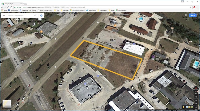
Highway 35, Port Lavaca, TX 77979

Property Detail
Highway 35
78270
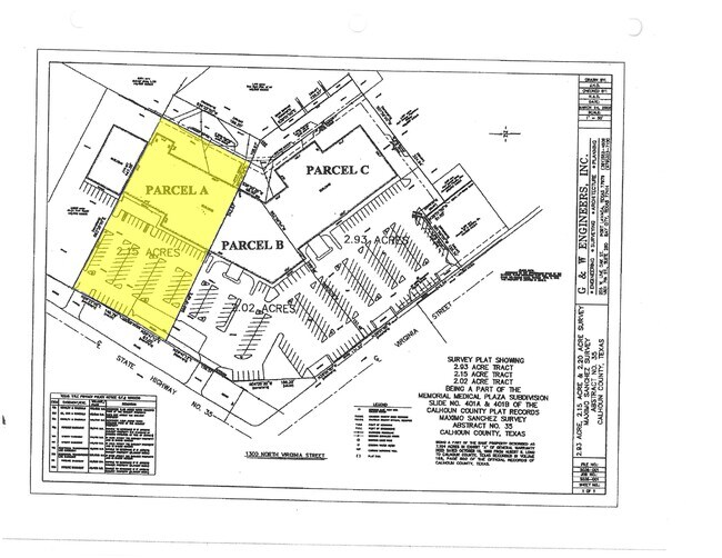
A0035 MAXIMO SANCHEZ, TRACT PT 29, ACRES 2.14, MEMORIAL MEDICAL PLAZA PARCEL 1
Commercialnec
CALHOUN
B and X Area of moderate flood hazard, usually the area between the limits of the 100-year and 500-year floods.
Texas
2025
2.14 AC
2025
Texas South Area
000200
Other Market Areas
32,680 SF
Port Lavaca, TX
NEARBY LISTINGS FOR SALE OR LEASE
DEMOGRAPHICS near Highway 35
1 mile
3 mile
5 mile
2025 Total Population
5,464
12,797
14,602
2030 Population
5,534
13,033
14,857
Pop Growth 2025-2030
+ 1.28%
+ 1.84%
+ 1.75%
Average Age
39
39
40
2025 Total Households
1,980
4,584
5,272
HH Growth 2025-2030
+ 1.46%
+ 1.99%
+ 1.90%
Median Household Inc
$59,575
$65,517
$67,080
Avg Household Size
2.70
2.70
2.70
2025 Avg HH Vehicles
2.00
2.00
2.00
Median Home Value
$124,531
$147,394
$156,924
Median Year Built
1970
1974
1975
Nearby Places
Map Layers
Map Styles
 Street
 Aerial
Layers
 Traffic
 Biking
Places
Listings with unknown addresses are not visible on the map
- Restaurants
- Banks
- Shops
- Fitness
- Groceries
SALE & LEASE HISTORY
LISTING DATE
SALE/LEASE

Aug 26, 2017
For Lease
Nearby Properties
Address
Land Use
TOTAL SIZE
Lot Size
Zoning
Address
Land Use
TOTAL SIZE
Lot Size
Zoning
13 SF
998.63 AC
Address
Land Use
TOTAL SIZE
Lot Size
Zoning
Address
Land Use
TOTAL SIZE
Lot Size
Zoning
253,184 SF
50 AC
Address
Land Use
TOTAL SIZE
Lot Size
Zoning
93,017 SF
2.56 AC
Address
Land Use
TOTAL SIZE
Lot Size
Zoning
68,115 SF
12.89 AC
Address
Land Use
TOTAL SIZE
Lot Size
Zoning
45,060 SF
2.68 AC
Address
Land Use
TOTAL SIZE
Lot Size
Zoning
53,860 SF
2.28 AC
Address
Land Use
TOTAL SIZE
Lot Size
Zoning
155,202 SF
19.21 AC
Address
Land Use
TOTAL SIZE
Lot Size
Zoning
52,320 SF
1.72 AC
Address
Land Use
TOTAL SIZE
Lot Size
Zoning
35,055 SF
1.29 AC
Address
Land Use
TOTAL SIZE
Lot Size
Zoning
1,210 SF
144.35 AC
Address
Land Use
TOTAL SIZE
Lot Size
Zoning
29,502 SF
3.30 AC
Address
Land Use
TOTAL SIZE
Lot Size
Zoning
42,848 SF
10.79 AC
Address
Land Use
TOTAL SIZE
Lot Size
Zoning
31,564 SF
8.17 AC
Address
Land Use
TOTAL SIZE
Lot Size
Zoning
47,675 SF
12.04 AC
Address
Land Use
TOTAL SIZE
Lot Size
Zoning
44,571 SF
4.49 AC
Address
Land Use
TOTAL SIZE
Lot Size
Zoning
59,364 SF
5.70 AC
Address
Land Use
TOTAL SIZE
Lot Size
Zoning
55,070 SF
12.79 AC
Address
Land Use
TOTAL SIZE
Lot Size
Zoning
103,451 SF
10 AC
Address
Land Use
TOTAL SIZE
Lot Size
Zoning
46,204 SF
6.82 AC
Address
Land Use
TOTAL SIZE
Lot Size
Zoning
105,600 SF
18.21 AC
Address
Land Use
TOTAL SIZE
Lot Size
Zoning
256,010 SF
18.83 AC
Address
Land Use
TOTAL SIZE
Lot Size
Zoning
22,416 SF
8.05 AC
Address
Land Use
TOTAL SIZE
Lot Size
Zoning
114,420 SF
6 AC
Address
Land Use
TOTAL SIZE
Lot Size
Zoning
15,240 SF
10 AC
Address
Land Use
TOTAL SIZE
Lot Size
Zoning
31.63 AC
Address
Land Use
TOTAL SIZE
Lot Size
Zoning
36,204 SF
9.76 AC
Address
Land Use
TOTAL SIZE
Lot Size
Zoning
21,880 SF
12.01 AC
Address
Land Use
TOTAL SIZE
Lot Size
Zoning
36,372 SF
7.21 AC
Address
Land Use
TOTAL SIZE
Lot Size
Zoning
123,240 SF
12.81 AC
The World's #1 Commercial Real Estate Marketplace
Connect with us
© 2026 CoStar Group
The information above has been obtained from sources believed reliable. While we do not doubt its accuracy we have not verified it and make no guarantee, warranty or representation about it. It is your responsibility to independently confirm its accuracy and completeness. Any projections, opinions, assumptions, or estimates used are for example only and do not represent the current or future performance of the property. The value of this transaction to you depends on tax and other factors which should be evaluated by your tax, financial, and legal advisors. You and your advisors should conduct a careful, independent investigation of the property to determine to your satisfaction the suitability of the property for your needs.