Property Record
Highway 359, Laredo, TX 78043
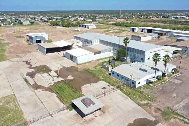

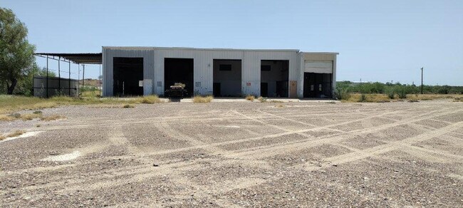

Property Detail
Highway 359
Laredo, TX
ABST 296 POR 32 A TREVINO 6.0394 ACS TR 19 TANQUECITOS
221421
WEBB
Commercialnec
Texas
A Areas with a 1% annual chance of flooding and a 26% chance of flooding over the life of a 30-year mortgage.
18
2023
6.04 AC
2025
Texas South Area
001003
Other Market Areas
36,252 SF
NEARBY LISTINGS FOR SALE OR LEASE
DEMOGRAPHICS near Highway 359
1 mile
3 mile
5 mile
2024 Total Population
1,829
2,582
32,169
2029 Population
1,893
2,703
32,977
Pop Growth 2024-2029
+ 3.50%
+ 4.69%
+ 2.51%
Average Age
31
30
32
2024 Total Households
433
625
8,502
HH Growth 2024-2029
+ 3.70%
+ 4.96%
+ 2.66%
Median Household Inc
$45,125
$47,819
$74,918
Avg Household Size
4.00
4.00
3.70
2024 Avg HH Vehicles
2.00
2.00
3.00
Median Home Value
$142,934
$167,391
$191,725
Median Year Built
1995
1998
2003
Nearby Places
Map Layers
Map Styles
 Street
 Aerial
Transit
 Traffic
 Biking
Places
Listings with unknown addresses are not visible on the map
- Restaurants
- Banks
- Shops
- Fitness
- Groceries
PUBLIC TRANSPORTATION
AIRPORT
Laredo International
Drive
Walk
Distance
Laredo International
16 min
8.5 mi
SALE & LEASE HISTORY
LISTING DATE
SALE/LEASE

Oct 28, 2021
For Lease
Nearby Properties
Address
Land Use
TOTAL SIZE
Lot Size
Zoning
Address
Land Use
TOTAL SIZE
Lot Size
Zoning
103,717 SF
17.92 AC
M1
Address
Land Use
TOTAL SIZE
Lot Size
Zoning
70,843 SF
20 AC
Address
Land Use
TOTAL SIZE
Lot Size
Zoning
159,674 SF
3.63 AC
B4
Address
Land Use
TOTAL SIZE
Lot Size
Zoning
47,407 SF
22.36 AC
M2
Address
Land Use
TOTAL SIZE
Lot Size
Zoning
73,030 SF
29.65 AC
Address
Land Use
TOTAL SIZE
Lot Size
Zoning
33,557 SF
7.30 AC
Address
Land Use
TOTAL SIZE
Lot Size
Zoning
122 AC
M2
Address
Land Use
TOTAL SIZE
Lot Size
Zoning
11,024 SF
32.61 AC
Address
Land Use
TOTAL SIZE
Lot Size
Zoning
106.87 AC
M2
Address
Land Use
TOTAL SIZE
Lot Size
Zoning
23,030 SF
5.06 AC
Address
Land Use
TOTAL SIZE
Lot Size
Zoning
17,646 SF
3.93 AC
Address
Land Use
TOTAL SIZE
Lot Size
Zoning
26,399 SF
5 AC
M1
Address
Land Use
TOTAL SIZE
Lot Size
Zoning
31,776 SF
4.69 AC
M1
Address
Land Use
TOTAL SIZE
Lot Size
Zoning
3,392 SF
4.64 AC
Address
Land Use
TOTAL SIZE
Lot Size
Zoning
13,150 SF
7.66 AC
M1
Address
Land Use
TOTAL SIZE
Lot Size
Zoning
15,860 SF
10 AC
M1
Address
Land Use
TOTAL SIZE
Lot Size
Zoning
26,127 SF
3.20 AC
M1
Address
Land Use
TOTAL SIZE
Lot Size
Zoning
14,560 SF
4.16 AC
Address
Land Use
TOTAL SIZE
Lot Size
Zoning
3,511 SF
5.51 AC
Address
Land Use
TOTAL SIZE
Lot Size
Zoning
3,813 SF
28.49 AC
Address
Land Use
TOTAL SIZE
Lot Size
Zoning
Address
Land Use
TOTAL SIZE
Lot Size
Zoning
8,530 SF
7.41 AC
B3
Address
Land Use
TOTAL SIZE
Lot Size
Zoning
4,540 SF
3.37 AC
M1
Address
Land Use
TOTAL SIZE
Lot Size
Zoning
20,018 SF
5.96 AC
Address
Land Use
TOTAL SIZE
Lot Size
Zoning
18,309 SF
9.11 AC
Address
Land Use
TOTAL SIZE
Lot Size
Zoning
30 AC
R3
Address
Land Use
TOTAL SIZE
Lot Size
Zoning
1,600 SF
4.27 AC
The World's #1 Commercial Real Estate Marketplace
Connect with us
© 2026 CoStar Group
The information above has been obtained from sources believed reliable. While we do not doubt its accuracy we have not verified it and make no guarantee, warranty or representation about it. It is your responsibility to independently confirm its accuracy and completeness. Any projections, opinions, assumptions, or estimates used are for example only and do not represent the current or future performance of the property. The value of this transaction to you depends on tax and other factors which should be evaluated by your tax, financial, and legal advisors. You and your advisors should conduct a careful, independent investigation of the property to determine to your satisfaction the suitability of the property for your needs.