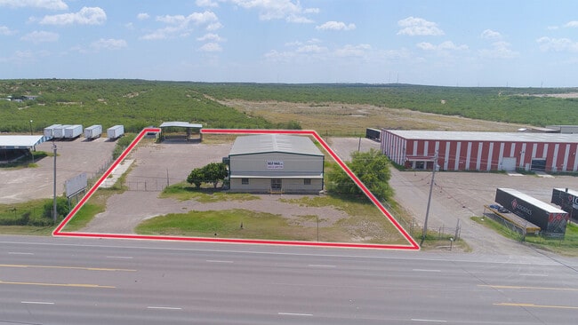
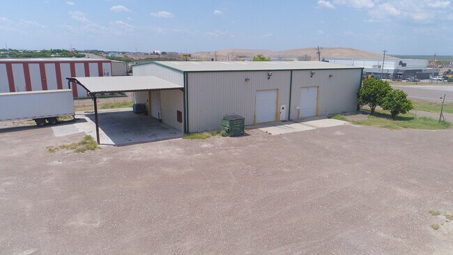
Property Record
Highway 359, Laredo, TX 78043

Property Detail
Highway 359
394888
ABST 296 POR 32 A TREVINO 1.7345 ACS
Commercialnec
WEBB
M1
Texas
B and X Area of moderate flood hazard, usually the area between the limits of the 100-year and 500-year floods.
1.74 AC
2024
Texas South Area
2025
Other Market Areas
0018101014
Laredo, TX
6,000 SF
NEARBY LISTINGS FOR SALE OR LEASE
DEMOGRAPHICS near Highway 359
1 mile
3 mile
5 mile
2025 Total Population
1,003
16,959
87,597
2030 Population
1,064
17,580
89,791
Pop Growth 2025-2030
+ 6.08%
+ 3.66%
+ 2.50%
Average Age
30
31
33
2025 Total Households
248
4,426
24,100
HH Growth 2025-2030
+ 6.45%
+ 3.86%
+ 2.62%
Median Household Inc
$51,842
$84,416
$56,838
Avg Household Size
3.90
3.80
3.60
2025 Avg HH Vehicles
2.00
2.00
2.00
Median Home Value
$188,596
$214,225
$176,207
Median Year Built
2003
2005
1997
Nearby Places
Map Layers
Map Styles
 Street
 Aerial
Transit
 Traffic
 Biking
Places
Listings with unknown addresses are not visible on the map
- Restaurants
- Banks
- Shops
- Fitness
- Groceries
PUBLIC TRANSPORTATION
AIRPORT
Laredo International
Drive
Walk
Distance
Laredo International
14 min
7.0 mi
SALE & LEASE HISTORY
LISTING DATE
SALE/LEASE

Aug 21, 2020
For Lease
Nearby Properties
Address
Land Use
TOTAL SIZE
Lot Size
Zoning
Address
Land Use
TOTAL SIZE
Lot Size
Zoning
310,346 SF
87.65 AC
R1A
Address
Land Use
TOTAL SIZE
Lot Size
Zoning
347,773 SF
49.74 AC
R1
Address
Land Use
TOTAL SIZE
Lot Size
Zoning
95,769 SF
10 AC
R1
Address
Land Use
TOTAL SIZE
Lot Size
Zoning
70,843 SF
20 AC
Address
Land Use
TOTAL SIZE
Lot Size
Zoning
81,470 SF
36.89 AC
Address
Land Use
TOTAL SIZE
Lot Size
Zoning
67,991 SF
3.74 AC
Address
Land Use
TOTAL SIZE
Lot Size
Zoning
50,754 SF
5.43 AC
B3
Address
Land Use
TOTAL SIZE
Lot Size
Zoning
47,407 SF
22.36 AC
M2
Address
Land Use
TOTAL SIZE
Lot Size
Zoning
74,690 SF
5.90 AC
Address
Land Use
TOTAL SIZE
Lot Size
Zoning
85,034 SF
18.80 AC
Address
Land Use
TOTAL SIZE
Lot Size
Zoning
73,030 SF
29.65 AC
Address
Land Use
TOTAL SIZE
Lot Size
Zoning
15,600 SF
1.41 AC
B4
Address
Land Use
TOTAL SIZE
Lot Size
Zoning
11,428 SF
2 AC
Address
Land Use
TOTAL SIZE
Lot Size
Zoning
33,557 SF
7.30 AC
Address
Land Use
TOTAL SIZE
Lot Size
Zoning
32,570 SF
2.21 AC
B3
Address
Land Use
TOTAL SIZE
Lot Size
Zoning
29,840 SF
1.47 AC
B3
Address
Land Use
TOTAL SIZE
Lot Size
Zoning
4,404 SF
4.08 AC
Address
Land Use
TOTAL SIZE
Lot Size
Zoning
12,638 SF
4.50 AC
Address
Land Use
TOTAL SIZE
Lot Size
Zoning
122 AC
M2
Address
Land Use
TOTAL SIZE
Lot Size
Zoning
11,024 SF
32.61 AC
Address
Land Use
TOTAL SIZE
Lot Size
Zoning
12.36 AC
B4
Address
Land Use
TOTAL SIZE
Lot Size
Zoning
18,192 SF
2.59 AC
Address
Land Use
TOTAL SIZE
Lot Size
Zoning
9.23 AC
B4
Address
Land Use
TOTAL SIZE
Lot Size
Zoning
106.87 AC
M2
Address
Land Use
TOTAL SIZE
Lot Size
Zoning
8,946 SF
2.90 AC
B3
Address
Land Use
TOTAL SIZE
Lot Size
Zoning
23,030 SF
5.06 AC
Address
Land Use
TOTAL SIZE
Lot Size
Zoning
9,000 SF
2.10 AC
B3
Address
Land Use
TOTAL SIZE
Lot Size
Zoning
6,435 SF
4 AC
R1
Address
Land Use
TOTAL SIZE
Lot Size
Zoning
17,646 SF
3.93 AC
Address
Land Use
TOTAL SIZE
Lot Size
Zoning
32.92 AC
M1
The World's #1 Commercial Real Estate Marketplace
Connect with us
© 2026 CoStar Group
The information above has been obtained from sources believed reliable. While we do not doubt its accuracy we have not verified it and make no guarantee, warranty or representation about it. It is your responsibility to independently confirm its accuracy and completeness. Any projections, opinions, assumptions, or estimates used are for example only and do not represent the current or future performance of the property. The value of this transaction to you depends on tax and other factors which should be evaluated by your tax, financial, and legal advisors. You and your advisors should conduct a careful, independent investigation of the property to determine to your satisfaction the suitability of the property for your needs.