Property Record
Highway 36, Millstone Twp, NJ 07718


Save to a Folder
{{folder.Name}}
{{folder.ListingIds.length}} Properties
{{folder.ListingIds.length}} Property
Create a New Folder
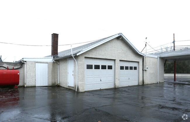
Property Detail
Highway 36
32-00297-0000-00017
MONMOUTH
Commercialnec
New Jersey
C125
21
AE The base floodplain where base flood elevations are provided. AE Zones are now used on new format FIRMs instead of A1-A30 Zones.
0.20 AC
2025
Eastern Monmouth
2026
Northern New Jersey
800500
Lakewood-New Brunswick, NJ
6,364 SF
NEARBY LISTINGS FOR SALE OR LEASE
DEMOGRAPHICS near Highway 36
1 mile
3 mile
5 mile
2025 Total Population
9,798
53,091
103,355
2030 Population
9,749
52,886
102,749
Pop Growth 2025-2030
(0.50%)
(0.39%)
(0.59%)
Average Age
41
42
43
2025 Total Households
3,447
19,421
38,393
HH Growth 2025-2030
(0.70%)
(0.57%)
(0.75%)
Median Household Inc
$131,485
$119,172
$123,322
Avg Household Size
2.70
2.60
2.60
2025 Avg HH Vehicles
2.00
2.00
2.00
Median Home Value
$536,562
$522,085
$599,318
Median Year Built
1958
1965
1967
Nearby Places
Map Layers
Map Styles
 Street
 Aerial
Layers
 Traffic
 Biking
Places
Listings with unknown addresses are not visible on the map
- Restaurants
- Banks
- Shops
- Fitness
- Groceries
PUBLIC TRANSPORTATION
COMMUTER RAIL
Middletown Nj (North Jersey Coast Line - NJ TRANSIT RAIL)
Drive
Walk
Distance
Middletown Nj (North Jersey Coast Line - NJ TRANSIT RAIL)
8 min
3.5 mi
Hazlet (North Jersey Coast Line - NJ Transit Commuter Rail (NJ Transit))
Drive
Walk
Distance
Hazlet (North Jersey Coast Line - NJ Transit Commuter Rail (NJ Transit))
9 min
7.1 mi
AIRPORT
Newark Liberty International
Drive
Walk
Distance
Newark Liberty International
45 min
33.9 mi
Freight Ports
New York Container Terminal
Drive
Walk
Distance
New York Container Terminal
38 min
29.1 mi
SALE & LEASE HISTORY
LISTING DATE
SALE/LEASE

Sep 24, 2016
For Sale
Nearby Properties
Address
Land Use
TOTAL SIZE
Lot Size
Zoning
Address
Land Use
TOTAL SIZE
Lot Size
Zoning
838,137 SF
253 AC
R45
Address
Land Use
TOTAL SIZE
Lot Size
Zoning
596.51 AC
CONREC
Address
Land Use
TOTAL SIZE
Lot Size
Zoning
6,500 SF
48.71 AC
CI
Address
Land Use
TOTAL SIZE
Lot Size
Zoning
37.83 AC
PUD
Address
Land Use
TOTAL SIZE
Lot Size
Zoning
147,236 SF
20.01 AC
MU15
Address
Land Use
TOTAL SIZE
Lot Size
Zoning
231,505 SF
21.75 AC
MU15
Address
Land Use
TOTAL SIZE
Lot Size
Zoning
22.51 AC
MF08
Address
Land Use
TOTAL SIZE
Lot Size
Zoning
118,375 SF
18.20 AC
MU15
Address
Land Use
TOTAL SIZE
Lot Size
Zoning
133,184 SF
14.10 AC
MU15
Address
Land Use
TOTAL SIZE
Lot Size
Zoning
83,449 SF
0.57 AC
SF05
Address
Land Use
TOTAL SIZE
Lot Size
Zoning
77,396 SF
11.47 AC
SF20
Address
Land Use
TOTAL SIZE
Lot Size
Zoning
237,821 SF
38.92 AC
SF20
Address
Land Use
TOTAL SIZE
Lot Size
Zoning
67,832 SF
10.46 AC
RGA
Address
Land Use
TOTAL SIZE
Lot Size
Zoning
127,410 SF
6.02 AC
MF15
Address
Land Use
TOTAL SIZE
Lot Size
Zoning
3,864 SF
260 AC
R15
Address
Land Use
TOTAL SIZE
Lot Size
Zoning
5 AC
PUD
Address
Land Use
TOTAL SIZE
Lot Size
Zoning
96.54 AC
I10
Address
Land Use
TOTAL SIZE
Lot Size
Zoning
117,594 SF
11.49 AC
MU15
Address
Land Use
TOTAL SIZE
Lot Size
Zoning
141,313 SF
23.19 AC
SF20
Address
Land Use
TOTAL SIZE
Lot Size
Zoning
83,416 SF
44.01 AC
R22
Address
Land Use
TOTAL SIZE
Lot Size
Zoning
132,885 SF
3.15 AC
SF05
Address
Land Use
TOTAL SIZE
Lot Size
Zoning
4,078 SF
15.14 AC
SC2
Address
Land Use
TOTAL SIZE
Lot Size
Zoning
43.97 AC
PD
Address
Land Use
TOTAL SIZE
Lot Size
Zoning
25,705 SF
7.15 AC
B-2
Address
Land Use
TOTAL SIZE
Lot Size
Zoning
145,070 SF
8.64 AC
B2
Address
Land Use
TOTAL SIZE
Lot Size
Zoning
67,982 SF
7.05 AC
MU15
Address
Land Use
TOTAL SIZE
Lot Size
Zoning
80,618 SF
6.59 AC
MU15
Address
Land Use
TOTAL SIZE
Lot Size
Zoning
75,292 SF
6.77 AC
B4
Address
Land Use
TOTAL SIZE
Lot Size
Zoning
1,221 SF
4.85 AC
AHMF
Address
Land Use
TOTAL SIZE
Lot Size
Zoning
67,999 SF
13.43 AC
B4
The World's #1 Commercial Real Estate Marketplace
Connect with us
© 2026 CoStar Group
The information above has been obtained from sources believed reliable. While we do not doubt its accuracy we have not verified it and make no guarantee, warranty or representation about it. It is your responsibility to independently confirm its accuracy and completeness. Any projections, opinions, assumptions, or estimates used are for example only and do not represent the current or future performance of the property. The value of this transaction to you depends on tax and other factors which should be evaluated by your tax, financial, and legal advisors. You and your advisors should conduct a careful, independent investigation of the property to determine to your satisfaction the suitability of the property for your needs.