Property Record
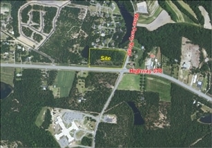
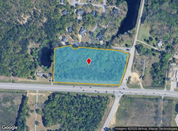
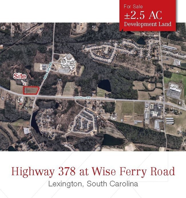
Highway 378, Lexington, SC 29072

NEARBY LISTINGS FOR SALE OR LEASE
Property Detail
Highway 378
004200-07-032
PT OF PARCEL C HWY ROW TAKEN .81 AC
Commercialacreage
Lexington
X
South Carolina
45063C0231J
7 AC
2025
Lexington
2024
Columbia
021050
Columbia, SC
DEMOGRAPHICS near Highway 378
1 Mile
3 Mile
5 Mile
2024 Total Population
3,445
30,718
61,048
2029 Population
3,759
33,500
66,636
Pop Growth 2024-2029
+ 9.11%
+ 9.06%
+ 9.15%
Average Age
37
40
40
2024 Total Households
1,254
11,344
23,068
HH Growth 2024-2029
+ 9.41%
+ 9.28%
+ 9.39%
Median Household Inc
$78,250
$91,168
$87,038
Avg Household Size
2.70
2.60
2.60
2024 Avg HH Vehicles
2.00
2.00
2.00
Median Home Value
$236,157
$260,843
$254,435
Median Year Built
2007
2002
1999
Nearby Places
Map Layers
Map Styles
 Street
 Aerial
- Restaurants
- Banks
- Shops
- Fitness
- Groceries
PUBLIC TRANSPORTATION
AIRPORT
Columbia Metro
DRIVE
WALK
Distance
Columbia Metro
33 min
15.6 mi
Freight Ports
North Charleston Terminal
DRIVE
WALK
Distance
North Charleston Terminal
134 min
113.5 mi
SALE & LEASE HISTORY
LISTING DATE
SALE/LEASE

Sep 07, 2017
For Sale
Nearby Properties
Address
Land Use
TOTAL SIZE
Lot Size
Zoning
Address
Land Use
TOTAL SIZE
Lot Size
Zoning
45,171 SF
8.38 AC
ID
Address
Land Use
TOTAL SIZE
Lot Size
Zoning
9,792 SF
7.47 AC
HDR
Address
Land Use
TOTAL SIZE
Lot Size
Zoning
96,585 SF
2.62 AC
ID
Address
Land Use
TOTAL SIZE
Lot Size
Zoning
41,883 SF
21.77 AC
ID
Address
Land Use
TOTAL SIZE
Lot Size
Zoning
49,494 SF
9.98 AC
ID
Address
Land Use
TOTAL SIZE
Lot Size
Zoning
78,665 SF
7.58 AC
GC
Address
Land Use
TOTAL SIZE
Lot Size
Zoning
15,343 SF
1.30 AC
GC
Address
Land Use
TOTAL SIZE
Lot Size
Zoning
18,300 SF
3.33 AC
RD
Address
Land Use
TOTAL SIZE
Lot Size
Zoning
3,810 SF
1.58 AC
ID
Address
Land Use
TOTAL SIZE
Lot Size
Zoning
59,201 SF
7.76 AC
GC
Address
Land Use
TOTAL SIZE
Lot Size
Zoning
79.51 AC
GC
Address
Land Use
TOTAL SIZE
Lot Size
Zoning
86,573 SF
4.92 AC
Address
Land Use
TOTAL SIZE
Lot Size
Zoning
1,378 SF
125.89 AC
RD
Address
Land Use
TOTAL SIZE
Lot Size
Zoning
30,555 SF
3.20 AC
GC
Address
Land Use
TOTAL SIZE
Lot Size
Zoning
14,287 SF
3.09 AC
GC
Address
Land Use
TOTAL SIZE
Lot Size
Zoning
52,296 SF
2.75 AC
GC
Address
Land Use
TOTAL SIZE
Lot Size
Zoning
50,982 SF
6.15 AC
GC
Address
Land Use
TOTAL SIZE
Lot Size
Zoning
24,198 SF
1.34 AC
GC
Address
Land Use
TOTAL SIZE
Lot Size
Zoning
37,874 SF
3.77 AC
GC
Address
Land Use
TOTAL SIZE
Lot Size
Zoning
21,177 SF
2.58 AC
GC
Address
Land Use
TOTAL SIZE
Lot Size
Zoning
4,339 SF
3.72 AC
GC
Address
Land Use
TOTAL SIZE
Lot Size
Zoning
6,760 SF
1.50 AC
ID
Address
Land Use
TOTAL SIZE
Lot Size
Zoning
9,918 SF
2.13 AC
RD
Address
Land Use
TOTAL SIZE
Lot Size
Zoning
4,850 SF
1.88 AC
ID
Address
Land Use
TOTAL SIZE
Lot Size
Zoning
12,600 SF
2.06 AC
ID
Address
Land Use
TOTAL SIZE
Lot Size
Zoning
121.12 AC
RD
Address
Land Use
TOTAL SIZE
Lot Size
Zoning
39,473 SF
5.95 AC
ID
Address
Land Use
TOTAL SIZE
Lot Size
Zoning
2,791 SF
1.12 AC
GC
Address
Land Use
TOTAL SIZE
Lot Size
Zoning
5,175 SF
1.61 AC
ID
Address
Land Use
TOTAL SIZE
Lot Size
Zoning
4,098 SF
0.99 AC
ID
The World's #1 Commercial Real Estate Marketplace
Connect with us
© 2025 CoStar Group
The information above has been obtained from sources believed reliable. While we do not doubt its accuracy we have not verified it and make no guarantee, warranty or representation about it. It is your responsibility to independently confirm its accuracy and completeness. Any projections, opinions, assumptions, or estimates used are for example only and do not represent the current or future performance of the property. The value of this transaction to you depends on tax and other factors which should be evaluated by your tax, financial, and legal advisors. You and your advisors should conduct a careful, independent investigation of the property to determine to your satisfaction the suitability of the property for your needs.