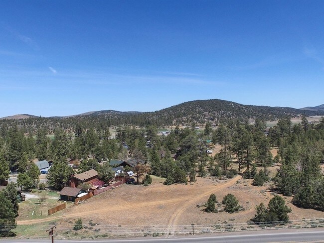
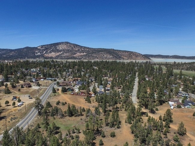
Property Record
Highway 38, Big Bear City, CA 92314

NEARBY LISTINGS FOR SALE OR LEASE
Property Detail
Highway 38
Riverside-San Bernardino-Ontario, CA
PTN N 1/2 S 1/2 LOT 1 SW 1/4 SEC 18 TP 2N R 2E LYING ELY OF STATE HGWY 10.35 AC
0314-422-36
San Bernardino
Vacantlandnec
California
D
1
06071C7315H
10.35 AC
2024
Redlands/Loma Linda
2025
Inland Empire (California)
011405
DEMOGRAPHICS near Highway 38
1 Mile
3 Mile
5 Mile
2024 Total Population
3,535
11,347
13,158
2029 Population
3,529
11,161
12,883
Pop Growth 2024-2029
(0.17%)
(1.64%)
(2.09%)
Average Age
45
44
44
2024 Total Households
1,534
4,887
5,708
HH Growth 2024-2029
(0.26%)
(1.84%)
(2.31%)
Median Household Inc
$63,421
$62,584
$64,871
Avg Household Size
2.30
2.20
2.20
2024 Avg HH Vehicles
2.00
2.00
2.00
Median Home Value
$527,826
$471,459
$499,712
Median Year Built
1979
1977
1977
Nearby Places
Map Layers
Map Styles
 Street
 Aerial
- Restaurants
- Banks
- Shops
- Fitness
- Groceries
SALE & LEASE HISTORY
LISTING DATE
SALE/LEASE

Sep 06, 2017
For Sale
Nov 22, 2019
For Sale
Nearby Properties
Address
Land Use
TOTAL SIZE
Lot Size
Zoning
Address
Land Use
TOTAL SIZE
Lot Size
Zoning
31,584 SF
2.63 AC
Address
Land Use
TOTAL SIZE
Lot Size
Zoning
65,260 SF
3.55 AC
BVIC
Address
Land Use
TOTAL SIZE
Lot Size
Zoning
239.80 AC
BVRL20
Address
Land Use
TOTAL SIZE
Lot Size
Zoning
15,403 SF
61.50 AC
BVRS
Address
Land Use
TOTAL SIZE
Lot Size
Zoning
686 SF
0.99 AC
BVRS
Address
Land Use
TOTAL SIZE
Lot Size
Zoning
1.85 AC
BVCG
Address
Land Use
TOTAL SIZE
Lot Size
Zoning
11,000 SF
2.53 AC
Address
Land Use
TOTAL SIZE
Lot Size
Zoning
6,930 SF
0.67 AC
BVCG
Address
Land Use
TOTAL SIZE
Lot Size
Zoning
1.27 AC
BVCG
Address
Land Use
TOTAL SIZE
Lot Size
Zoning
14,744 SF
3.39 AC
Address
Land Use
TOTAL SIZE
Lot Size
Zoning
11,326 SF
3.82 AC
Address
Land Use
TOTAL SIZE
Lot Size
Zoning
11,800 SF
0.34 AC
BVCS
Address
Land Use
TOTAL SIZE
Lot Size
Zoning
4,136 SF
0.80 AC
BVRS
Address
Land Use
TOTAL SIZE
Lot Size
Zoning
2,340 SF
0.31 AC
BVCG
Address
Land Use
TOTAL SIZE
Lot Size
Zoning
7.71 AC
BVCG
Address
Land Use
TOTAL SIZE
Lot Size
Zoning
60 AC
BVRS1
Address
Land Use
TOTAL SIZE
Lot Size
Zoning
2,880 SF
8.95 AC
BVRL5
Address
Land Use
TOTAL SIZE
Lot Size
Zoning
9,606 SF
0.80 AC
BVCS
Address
Land Use
TOTAL SIZE
Lot Size
Zoning
4,908 SF
1.01 AC
BVRS1
Address
Land Use
TOTAL SIZE
Lot Size
Zoning
1.93 AC
BVIC
Address
Land Use
TOTAL SIZE
Lot Size
Zoning
17.50 AC
BVRL20
Address
Land Use
TOTAL SIZE
Lot Size
Zoning
8,683 SF
1.52 AC
BVRS1
Address
Land Use
TOTAL SIZE
Lot Size
Zoning
18,246 SF
16.11 AC
BVRS
Address
Land Use
TOTAL SIZE
Lot Size
Zoning
1,980 SF
0.17 AC
BVCG
Address
Land Use
TOTAL SIZE
Lot Size
Zoning
6,360 SF
0.38 AC
BVCG
Address
Land Use
TOTAL SIZE
Lot Size
Zoning
11,427 SF
6.52 AC
BVRS1
Address
Land Use
TOTAL SIZE
Lot Size
Zoning
3,760 SF
0.21 AC
BVRM
Address
Land Use
TOTAL SIZE
Lot Size
Zoning
12,811 SF
0.46 AC
BVCS
Address
Land Use
TOTAL SIZE
Lot Size
Zoning
2,640 SF
0.18 AC
BVCG
Address
Land Use
TOTAL SIZE
Lot Size
Zoning
0.59 AC
BVRS
The World's #1 Commercial Real Estate Marketplace
Connect with us
© 2025 CoStar Group
The information above has been obtained from sources believed reliable. While we do not doubt its accuracy we have not verified it and make no guarantee, warranty or representation about it. It is your responsibility to independently confirm its accuracy and completeness. Any projections, opinions, assumptions, or estimates used are for example only and do not represent the current or future performance of the property. The value of this transaction to you depends on tax and other factors which should be evaluated by your tax, financial, and legal advisors. You and your advisors should conduct a careful, independent investigation of the property to determine to your satisfaction the suitability of the property for your needs.