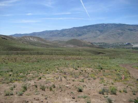
Property Record
Highway 40 W, Verdi, NV 89439
Property Detail
Highway 40 W
Reno, NV
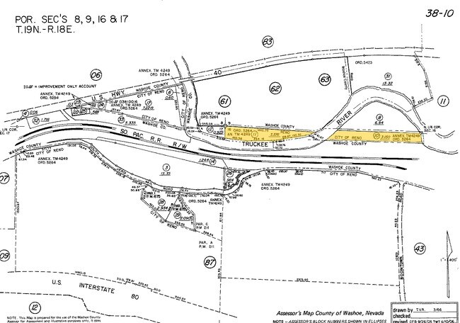
FR N2 NW4 SEC 16 TWP 19 RGE 18
038-010-05
WASHOE
Residentialacreage
Nevada
SF6 13% /
2
B and X Area of moderate flood hazard, usually the area between the limits of the 100-year and 500-year floods.
643.88 AC
0
N Outlying Washoe County
2026
Reno/Sparks
002302
NEARBY LISTINGS FOR SALE OR LEASE
-
-
View all Verdi listings for sale on LoopNet.com
DEMOGRAPHICS near Highway 40 W
1 mile
3 mile
5 mile
2025 Total Population
3,920
12,688
36,067
2030 Population
4,058
13,116
37,115
Pop Growth 2025-2030
+ 3.52%
+ 3.37%
+ 2.91%
Average Age
55
49
43
2025 Total Households
1,834
5,387
14,871
HH Growth 2025-2030
+ 3.71%
+ 3.58%
+ 3.06%
Median Household Inc
$121,692
$130,609
$104,847
Avg Household Size
2.10
2.30
2.40
2025 Avg HH Vehicles
2.00
2.00
2.00
Median Home Value
$724,738
$742,044
$688,294
Median Year Built
2008
2007
2000
Nearby Places
Map Layers
Map Styles
 Street
 Aerial
Layers
 Traffic
 Biking
Places
Listings with unknown addresses are not visible on the map
- Restaurants
- Banks
- Shops
- Fitness
- Groceries
PUBLIC TRANSPORTATION
AIRPORT
Reno/Tahoe International
Drive
Walk
Distance
Reno/Tahoe International
41 min
18.2 mi
Freight Ports
Port of Stockton
Drive
Walk
Distance
Port of Stockton
209 min
174.8 mi
Nearby Properties
Address
Land Use
TOTAL SIZE
Lot Size
Zoning
Address
Land Use
TOTAL SIZE
Lot Size
Zoning
252,869 SF
10.77 AC
MF14 97% /
Address
Land Use
TOTAL SIZE
Lot Size
Zoning
359,209 SF
8.83 AC
HC
Address
Land Use
TOTAL SIZE
Lot Size
Zoning
257,834 SF
14.94 AC
MS
Address
Land Use
TOTAL SIZE
Lot Size
Zoning
127,616 SF
20.80 AC
AC
Address
Land Use
TOTAL SIZE
Lot Size
Zoning
221,000 SF
13.78 AC
IC
Address
Land Use
TOTAL SIZE
Lot Size
Zoning
170,090 SF
11.60 AC
MS 91% / S
Address
Land Use
TOTAL SIZE
Lot Size
Zoning
206,891 SF
13.81 AC
IC
Address
Land Use
TOTAL SIZE
Lot Size
Zoning
182,000 SF
13.56 AC
IC
Address
Land Use
TOTAL SIZE
Lot Size
Zoning
182,656 SF
10.50 AC
IC
Address
Land Use
TOTAL SIZE
Lot Size
Zoning
115,848 SF
9.61 AC
PD
Address
Land Use
TOTAL SIZE
Lot Size
Zoning
14,540 SF
8.90 AC
HC
Address
Land Use
TOTAL SIZE
Lot Size
Zoning
133,701 SF
21.38 AC
I
Address
Land Use
TOTAL SIZE
Lot Size
Zoning
2,438 SF
1.27 AC
OS 28%/PF
Address
Land Use
TOTAL SIZE
Lot Size
Zoning
22,703 SF
5.43 AC
GC
Address
Land Use
TOTAL SIZE
Lot Size
Zoning
88,560 SF
4 AC
I
Address
Land Use
TOTAL SIZE
Lot Size
Zoning
18,098 SF
1.93 AC
PD
Address
Land Use
TOTAL SIZE
Lot Size
Zoning
18,059 SF
2.06 AC
PD
Address
Land Use
TOTAL SIZE
Lot Size
Zoning
678 SF
76.94 AC
SF6 34%/ S
Address
Land Use
TOTAL SIZE
Lot Size
Zoning
12,003 SF
18.23 AC
GR
Address
Land Use
TOTAL SIZE
Lot Size
Zoning
24,752 SF
1.37 AC
SPD
Address
Land Use
TOTAL SIZE
Lot Size
Zoning
49.20 AC
RR15
Address
Land Use
TOTAL SIZE
Lot Size
Zoning
61.14 AC
OS 29% / A
Address
Land Use
TOTAL SIZE
Lot Size
Zoning
16,905 SF
4.33 AC
I
Address
Land Use
TOTAL SIZE
Lot Size
Zoning
42,026 SF
5.79 AC
PD
Address
Land Use
TOTAL SIZE
Lot Size
Zoning
112.42 AC
SF9 52% /
Address
Land Use
TOTAL SIZE
Lot Size
Zoning
6,116 SF
1.22 AC
PD
Address
Land Use
TOTAL SIZE
Lot Size
Zoning
19,371 SF
1.27 AC
SPD
Address
Land Use
TOTAL SIZE
Lot Size
Zoning
13,272 SF
5.45 AC
PD
Address
Land Use
TOTAL SIZE
Lot Size
Zoning
0.74 AC
PD
The World's #1 Commercial Real Estate Marketplace
Connect with us
© 2026 CoStar Group
The information above has been obtained from sources believed reliable. While we do not doubt its accuracy we have not verified it and make no guarantee, warranty or representation about it. It is your responsibility to independently confirm its accuracy and completeness. Any projections, opinions, assumptions, or estimates used are for example only and do not represent the current or future performance of the property. The value of this transaction to you depends on tax and other factors which should be evaluated by your tax, financial, and legal advisors. You and your advisors should conduct a careful, independent investigation of the property to determine to your satisfaction the suitability of the property for your needs.