Property Record
Highway 41 S, Adel, GA 31620
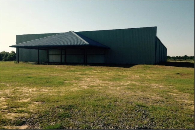

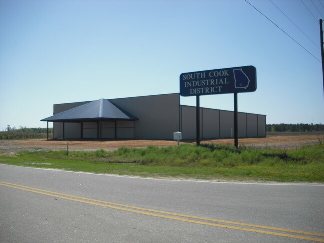
Property Detail
Highway 41 S
0051-075
LL 409 9TH LD
Governmentalpublicusegeneral
COOK
HI
Georgia
A Areas with a 1% annual chance of flooding and a 26% chance of flooding over the life of a 30-year mortgage.
138.62 AC
0
Valdosta/Lake Park
2025
Other Market Areas
960400
NEARBY LISTINGS FOR SALE OR LEASE
-
-
View all Adel listings for sale on LoopNet.com
DEMOGRAPHICS near Highway 41 S
1 mile
3 mile
5 mile
2025 Total Population
58
3,003
9,682
2030 Population
62
3,171
10,211
Pop Growth 2025-2030
+ 6.90%
+ 5.59%
+ 5.46%
Average Age
39
38
39
2025 Total Households
22
1,130
3,634
HH Growth 2025-2030
+ 4.55%
+ 5.58%
+ 5.48%
Median Household Inc
$39,374
$39,955
$44,874
Avg Household Size
2.60
2.60
2.60
2025 Avg HH Vehicles
2.00
2.00
2.00
Median Home Value
$174,999
$153,418
$147,951
Median Year Built
1993
1990
1986
Nearby Places
Map Layers
Map Styles
 Street
 Aerial
Layers
 Traffic
 Biking
Places
Listings with unknown addresses are not visible on the map
- Restaurants
- Banks
- Shops
- Fitness
- Groceries
PUBLIC TRANSPORTATION
AIRPORT
Valdosta Regional
Drive
Walk
Distance
Valdosta Regional
36 min
26.0 mi
Freight Ports
Georgia Ports - Brunswick
Drive
Walk
Distance
Georgia Ports - Brunswick
176 min
131.7 mi
SALE & LEASE HISTORY
LISTING DATE
SALE/LEASE

Sep 25, 2016
For Lease
Sep 23, 2016
For Sale
Mar 20, 2017
For Sale
Apr 20, 2017
For Sale
Nearby Properties
Address
Land Use
TOTAL SIZE
Lot Size
Zoning
Address
Land Use
TOTAL SIZE
Lot Size
Zoning
31,118 SF
140.05 AC
Address
Land Use
TOTAL SIZE
Lot Size
Zoning
391,614 SF
160.24 AC
HI
Address
Land Use
TOTAL SIZE
Lot Size
Zoning
11,604 SF
7.43 AC
R10
Address
Land Use
TOTAL SIZE
Lot Size
Zoning
60,000 SF
20.82 AC
HI
Address
Land Use
TOTAL SIZE
Lot Size
Zoning
56,952 SF
16.42 AC
HI
Address
Land Use
TOTAL SIZE
Lot Size
Zoning
20,100 SF
5.41 AC
RP
Address
Land Use
TOTAL SIZE
Lot Size
Zoning
4,212 SF
230.03 AC
WLI
Address
Land Use
TOTAL SIZE
Lot Size
Zoning
10,475 SF
4.65 AC
R10
Address
Land Use
TOTAL SIZE
Lot Size
Zoning
7,828 SF
8.23 AC
HI
Address
Land Use
TOTAL SIZE
Lot Size
Zoning
6,985 SF
31.29 AC
HI
Address
Land Use
TOTAL SIZE
Lot Size
Zoning
20,000 SF
10 AC
Address
Land Use
TOTAL SIZE
Lot Size
Zoning
41,132 SF
8.46 AC
HI
Address
Land Use
TOTAL SIZE
Lot Size
Zoning
24,400 SF
56.47 AC
Address
Land Use
TOTAL SIZE
Lot Size
Zoning
4,420 SF
0.90 AC
RP
Address
Land Use
TOTAL SIZE
Lot Size
Zoning
77,875 SF
40.52 AC
HI
Address
Land Use
TOTAL SIZE
Lot Size
Zoning
3,840 SF
4.12 AC
R8
Address
Land Use
TOTAL SIZE
Lot Size
Zoning
10,349 SF
2.36 AC
GB
Address
Land Use
TOTAL SIZE
Lot Size
Zoning
520.59 AC
Address
Land Use
TOTAL SIZE
Lot Size
Zoning
10,800 SF
0.82 AC
GB
Address
Land Use
TOTAL SIZE
Lot Size
Zoning
1,080 SF
520.86 AC
HI
Address
Land Use
TOTAL SIZE
Lot Size
Zoning
18,000 SF
17.60 AC
Address
Land Use
TOTAL SIZE
Lot Size
Zoning
46,400 SF
11.98 AC
HI
Address
Land Use
TOTAL SIZE
Lot Size
Zoning
422.77 AC
WLI
Address
Land Use
TOTAL SIZE
Lot Size
Zoning
Address
Land Use
TOTAL SIZE
Lot Size
Zoning
85,315 SF
6.40 AC
HI
Address
Land Use
TOTAL SIZE
Lot Size
Zoning
22,500 SF
10.28 AC
WLI
Address
Land Use
TOTAL SIZE
Lot Size
Zoning
391.76 AC
Address
Land Use
TOTAL SIZE
Lot Size
Zoning
13,600 SF
3.48 AC
Address
Land Use
TOTAL SIZE
Lot Size
Zoning
10,500 SF
1.52 AC
RP
The World's #1 Commercial Real Estate Marketplace
Connect with us
© 2026 CoStar Group
The information above has been obtained from sources believed reliable. While we do not doubt its accuracy we have not verified it and make no guarantee, warranty or representation about it. It is your responsibility to independently confirm its accuracy and completeness. Any projections, opinions, assumptions, or estimates used are for example only and do not represent the current or future performance of the property. The value of this transaction to you depends on tax and other factors which should be evaluated by your tax, financial, and legal advisors. You and your advisors should conduct a careful, independent investigation of the property to determine to your satisfaction the suitability of the property for your needs.