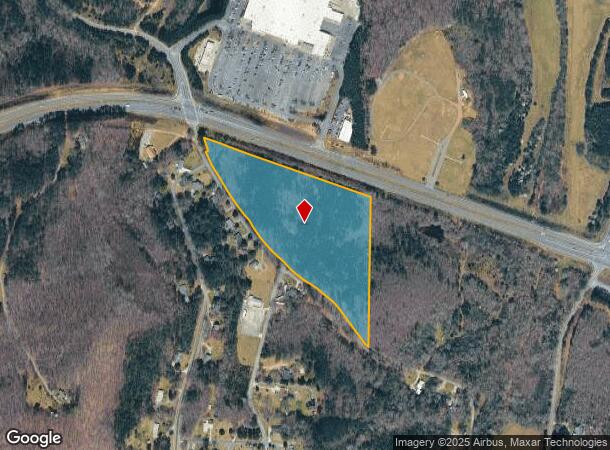
Property Record
Highway 411 Callier Springs Rd, Rome, GA 30161
NEARBY LISTINGS FOR SALE OR LEASE
Property Detail
Highway 411 Callier Springs Rd
K15W-005
LL352 23/3
Commercialacreage
Floyd
X
Georgia
13115C0284E
14.36 AC
2025
Georgia Northwest
2024
Other Market Areas
000900
Rome, GA
DEMOGRAPHICS near Highway 411 Callier Springs Rd
1 Mile
3 Mile
5 Mile
2024 Total Population
508
16,578
41,005
2029 Population
530
17,076
42,183
Pop Growth 2024-2029
+ 4.33%
+ 3.00%
+ 2.87%
Average Age
39
41
40
2024 Total Households
187
6,719
16,080
HH Growth 2024-2029
+ 4.81%
+ 2.98%
+ 2.93%
Median Household Inc
$67,031
$54,391
$52,505
Avg Household Size
2.60
2.40
2.40
2024 Avg HH Vehicles
2.00
2.00
2.00
Median Home Value
$177,884
$212,500
$193,565
Median Year Built
1983
1976
1972
Nearby Places
Map Layers
Map Styles
 Street
 Aerial
- Restaurants
- Banks
- Shops
- Fitness
- Groceries
SALE & LEASE HISTORY
LISTING DATE
SALE/LEASE

Sep 24, 2016
For Sale
Aug 01, 2017
For Sale
Nearby Properties
Address
Land Use
TOTAL SIZE
Lot Size
Zoning
Address
Land Use
TOTAL SIZE
Lot Size
Zoning
62,832 SF
H-I
Address
Land Use
TOTAL SIZE
Lot Size
Zoning
203,082 SF
22.05 AC
H-I
Address
Land Use
TOTAL SIZE
Lot Size
Zoning
141,680 SF
6.27 AC
U-M-U
Address
Land Use
TOTAL SIZE
Lot Size
Zoning
1,980 SF
40.80 AC
H-I
Address
Land Use
TOTAL SIZE
Lot Size
Zoning
17,904 SF
14.19 AC
H-I
Address
Land Use
TOTAL SIZE
Lot Size
Zoning
89,250 SF
7.05 AC
C-C
Address
Land Use
TOTAL SIZE
Lot Size
Zoning
42,440 SF
4.30 AC
C-C
Address
Land Use
TOTAL SIZE
Lot Size
Zoning
6,998 SF
15 AC
M-R
Address
Land Use
TOTAL SIZE
Lot Size
Zoning
184,996 SF
25.90 AC
C-C
Address
Land Use
TOTAL SIZE
Lot Size
Zoning
72,880 SF
Address
Land Use
TOTAL SIZE
Lot Size
Zoning
257,573 SF
25.64 AC
H-I
Address
Land Use
TOTAL SIZE
Lot Size
Zoning
296 SF
9.46 AC
Address
Land Use
TOTAL SIZE
Lot Size
Zoning
1,598 SF
11.46 AC
M-R
Address
Land Use
TOTAL SIZE
Lot Size
Zoning
10.03 AC
O-I
Address
Land Use
TOTAL SIZE
Lot Size
Zoning
0.17 AC
H-T-R
Address
Land Use
TOTAL SIZE
Lot Size
Zoning
37,890 SF
8.96 AC
O-I
Address
Land Use
TOTAL SIZE
Lot Size
Zoning
32,092 SF
2 AC
C-C
Address
Land Use
TOTAL SIZE
Lot Size
Zoning
47,136 SF
2 AC
C-C
Address
Land Use
TOTAL SIZE
Lot Size
Zoning
9,088 SF
8.27 AC
M-R
Address
Land Use
TOTAL SIZE
Lot Size
Zoning
1,001.41 AC
S-R
Address
Land Use
TOTAL SIZE
Lot Size
Zoning
41,296 SF
3.01 AC
C-C
Address
Land Use
TOTAL SIZE
Lot Size
Zoning
14,996 SF
4.21 AC
C-C
Address
Land Use
TOTAL SIZE
Lot Size
Zoning
6,191 SF
1.73 AC
C-C
Address
Land Use
TOTAL SIZE
Lot Size
Zoning
23,484 SF
2 AC
C-C
Address
Land Use
TOTAL SIZE
Lot Size
Zoning
33,743 SF
6.93 AC
C-C
Address
Land Use
TOTAL SIZE
Lot Size
Zoning
8.08 AC
Address
Land Use
TOTAL SIZE
Lot Size
Zoning
11.29 AC
O-I
Address
Land Use
TOTAL SIZE
Lot Size
Zoning
4,544 SF
3.24 AC
M-R
Address
Land Use
TOTAL SIZE
Lot Size
Zoning
3.70 AC
O-I
Address
Land Use
TOTAL SIZE
Lot Size
Zoning
1,656 SF
6 AC
L-I
The World's #1 Commercial Real Estate Marketplace
Connect with us
© 2026 CoStar Group
The information above has been obtained from sources believed reliable. While we do not doubt its accuracy we have not verified it and make no guarantee, warranty or representation about it. It is your responsibility to independently confirm its accuracy and completeness. Any projections, opinions, assumptions, or estimates used are for example only and do not represent the current or future performance of the property. The value of this transaction to you depends on tax and other factors which should be evaluated by your tax, financial, and legal advisors. You and your advisors should conduct a careful, independent investigation of the property to determine to your satisfaction the suitability of the property for your needs.