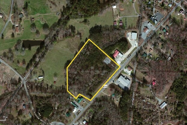
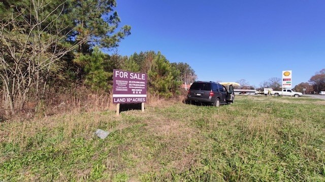
Property Record
Highway 411, White, GA 30184
NEARBY LISTINGS FOR SALE OR LEASE
-
-
View all White listings for sale on LoopNet.com
Property Detail
Highway 411
Atlanta-Sandy Springs-Roswell, GA
Com - Hwy 411/White
0089-0298-001
LL 298 299 LD 5 PARCEL 2 & 3
Agriculturalland
Bartow
X
Georgia
13015C0170H
7.17 AC
2024
Bartow County
2024
Atlanta
960103
DEMOGRAPHICS near Highway 411
1 Mile
3 Mile
5 Mile
2024 Total Population
1,107
2,571
16,386
2029 Population
1,209
2,809
17,946
Pop Growth 2024-2029
+ 9.21%
+ 9.26%
+ 9.52%
Average Age
40
40
40
2024 Total Households
395
916
6,014
HH Growth 2024-2029
+ 9.11%
+ 9.06%
+ 9.26%
Median Household Inc
$86,445
$85,274
$83,031
Avg Household Size
2.80
2.80
2.70
2024 Avg HH Vehicles
2.00
2.00
2.00
Median Home Value
$270,154
$269,137
$252,620
Median Year Built
1994
1994
1997
Nearby Places
Map Layers
Map Styles
 Street
 Aerial
- Restaurants
- Banks
- Shops
- Fitness
- Groceries
SALE & LEASE HISTORY
LISTING DATE
SALE/LEASE

Dec 09, 2020
For Sale
Nearby Properties
Address
Land Use
TOTAL SIZE
Lot Size
Zoning
Address
Land Use
TOTAL SIZE
Lot Size
Zoning
791,880 SF
77.99 AC
A1
Address
Land Use
TOTAL SIZE
Lot Size
Zoning
144,208 SF
585.38 AC
IN
Address
Land Use
TOTAL SIZE
Lot Size
Zoning
271,357 SF
375.69 AC
IN
Address
Land Use
TOTAL SIZE
Lot Size
Zoning
268,772 SF
168.31 AC
Address
Land Use
TOTAL SIZE
Lot Size
Zoning
107,992 SF
46 AC
IN
Address
Land Use
TOTAL SIZE
Lot Size
Zoning
1,228,855 SF
193.36 AC
Address
Land Use
TOTAL SIZE
Lot Size
Zoning
823,607 SF
43.60 AC
A1
Address
Land Use
TOTAL SIZE
Lot Size
Zoning
587,459 SF
146.14 AC
A1
Address
Land Use
TOTAL SIZE
Lot Size
Zoning
1,107,665 SF
114.40 AC
Address
Land Use
TOTAL SIZE
Lot Size
Zoning
972,763 SF
68.78 AC
Address
Land Use
TOTAL SIZE
Lot Size
Zoning
880,122 SF
146.14 AC
Address
Land Use
TOTAL SIZE
Lot Size
Zoning
999,291 SF
73.85 AC
A1
Address
Land Use
TOTAL SIZE
Lot Size
Zoning
311,878 SF
161.30 AC
Address
Land Use
TOTAL SIZE
Lot Size
Zoning
523,059 SF
72.54 AC
Address
Land Use
TOTAL SIZE
Lot Size
Zoning
526,400 SF
64.52 AC
Address
Land Use
TOTAL SIZE
Lot Size
Zoning
702,946 SF
146.14 AC
I2
Address
Land Use
TOTAL SIZE
Lot Size
Zoning
288,480 SF
40.14 AC
A1
Address
Land Use
TOTAL SIZE
Lot Size
Zoning
273,560 SF
31.38 AC
Address
Land Use
TOTAL SIZE
Lot Size
Zoning
396,000 SF
60.87 AC
Address
Land Use
TOTAL SIZE
Lot Size
Zoning
328,000 SF
43.09 AC
Address
Land Use
TOTAL SIZE
Lot Size
Zoning
207,440 SF
24.78 AC
Address
Land Use
TOTAL SIZE
Lot Size
Zoning
262,316 SF
Address
Land Use
TOTAL SIZE
Lot Size
Zoning
311,476 SF
36.54 AC
Address
Land Use
TOTAL SIZE
Lot Size
Zoning
393,536 SF
146.14 AC
Address
Land Use
TOTAL SIZE
Lot Size
Zoning
181.56 AC
A1
Address
Land Use
TOTAL SIZE
Lot Size
Zoning
130,000 SF
20 AC
Address
Land Use
TOTAL SIZE
Lot Size
Zoning
3,890 SF
Address
Land Use
TOTAL SIZE
Lot Size
Zoning
189,430 SF
Address
Land Use
TOTAL SIZE
Lot Size
Zoning
165.60 AC
IN
Address
Land Use
TOTAL SIZE
Lot Size
Zoning
77,586 SF
4.57 AC
IN
The World's #1 Commercial Real Estate Marketplace
Connect with us
© 2026 CoStar Group
The information above has been obtained from sources believed reliable. While we do not doubt its accuracy we have not verified it and make no guarantee, warranty or representation about it. It is your responsibility to independently confirm its accuracy and completeness. Any projections, opinions, assumptions, or estimates used are for example only and do not represent the current or future performance of the property. The value of this transaction to you depends on tax and other factors which should be evaluated by your tax, financial, and legal advisors. You and your advisors should conduct a careful, independent investigation of the property to determine to your satisfaction the suitability of the property for your needs.