Property Record
Highway 417, Moore, SC 29369

Property Detail
Highway 417
Spartanburg, SC
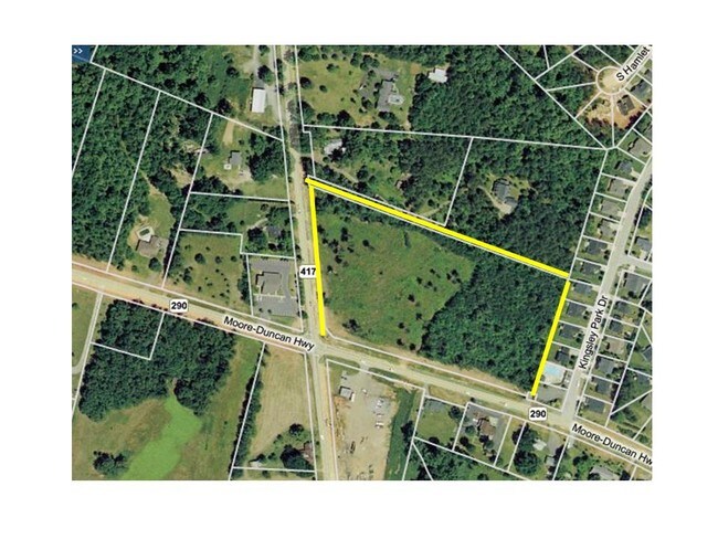
E SIDE HWY 417 N SIDE MOORE DUNCAN HWY PB 155-833 PB 124-756 HWY RW TAKEN 42.514A TR 85 PB 171-501
5-32-00-059.00
SPARTANBURG
Commercialacreage
South Carolina
B and X Area of moderate flood hazard, usually the area between the limits of the 100-year and 500-year floods.
8.41 AC
2024
Rt 290 Corridor
2025
Greenville/Spartanburg
023402
NEARBY LISTINGS FOR SALE OR LEASE
DEMOGRAPHICS near Highway 417
1 mile
3 mile
5 mile
2025 Total Population
4,091
22,619
58,959
2030 Population
4,570
25,380
66,035
Pop Growth 2025-2030
+ 11.71%
+ 12.21%
+ 12.00%
Average Age
41
40
39
2025 Total Households
1,537
8,562
22,584
HH Growth 2025-2030
+ 11.71%
+ 12.23%
+ 12.01%
Median Household Inc
$93,012
$91,862
$73,867
Avg Household Size
2.60
2.60
2.60
2025 Avg HH Vehicles
2.00
2.00
2.00
Median Home Value
$282,257
$291,364
$274,683
Median Year Built
1998
2001
1998
Nearby Places
Map Layers
Map Styles
 Street
 Aerial
Transit
 Traffic
 Biking
Places
Listings with unknown addresses are not visible on the map
- Restaurants
- Banks
- Shops
- Fitness
- Groceries
PUBLIC TRANSPORTATION
COMMUTER RAIL
Spartanburg Amtrak Station (Crescent - Amtrak)
Drive
Walk
Distance
Spartanburg Amtrak Station (Crescent - Amtrak)
17 min
9.3 mi
AIRPORT
Greenville Spartanburg International
Drive
Walk
Distance
Greenville Spartanburg International
21 min
12.3 mi
Freight Ports
North Charleston Terminal
Drive
Walk
Distance
North Charleston Terminal
214 min
191.0 mi
SALE & LEASE HISTORY
LISTING DATE
SALE/LEASE

Sep 24, 2016
For Sale
Nearby Properties
Address
Land Use
TOTAL SIZE
Lot Size
Zoning
Address
Land Use
TOTAL SIZE
Lot Size
Zoning
210.98 AC
Address
Land Use
TOTAL SIZE
Lot Size
Zoning
14,168 SF
8.33 AC
Address
Land Use
TOTAL SIZE
Lot Size
Zoning
27,288 SF
19.85 AC
Address
Land Use
TOTAL SIZE
Lot Size
Zoning
2,417 SF
21.12 AC
Address
Land Use
TOTAL SIZE
Lot Size
Zoning
2,176 SF
20.63 AC
Address
Land Use
TOTAL SIZE
Lot Size
Zoning
15,300 SF
13.48 AC
Address
Land Use
TOTAL SIZE
Lot Size
Zoning
38,313 SF
15.53 AC
Address
Land Use
TOTAL SIZE
Lot Size
Zoning
3,937 SF
11.29 AC
Address
Land Use
TOTAL SIZE
Lot Size
Zoning
10,126 SF
11.86 AC
Address
Land Use
TOTAL SIZE
Lot Size
Zoning
6,713 SF
0.61 AC
Address
Land Use
TOTAL SIZE
Lot Size
Zoning
3,433 SF
18.66 AC
Address
Land Use
TOTAL SIZE
Lot Size
Zoning
55.89 AC
Address
Land Use
TOTAL SIZE
Lot Size
Zoning
393,732 SF
11.88 AC
Address
Land Use
TOTAL SIZE
Lot Size
Zoning
5,860 SF
0.90 AC
Address
Land Use
TOTAL SIZE
Lot Size
Zoning
6,086 SF
1.20 AC
Address
Land Use
TOTAL SIZE
Lot Size
Zoning
170,279 SF
17.56 AC
Address
Land Use
TOTAL SIZE
Lot Size
Zoning
51,914 SF
13.69 AC
Address
Land Use
TOTAL SIZE
Lot Size
Zoning
6,121 SF
2.78 AC
Address
Land Use
TOTAL SIZE
Lot Size
Zoning
6,609 SF
2.01 AC
Address
Land Use
TOTAL SIZE
Lot Size
Zoning
5,697 SF
23.10 AC
Address
Land Use
TOTAL SIZE
Lot Size
Zoning
1,861 SF
155.78 AC
Address
Land Use
TOTAL SIZE
Lot Size
Zoning
5,296 SF
0.61 AC
Address
Land Use
TOTAL SIZE
Lot Size
Zoning
3,851 SF
0.60 AC
Address
Land Use
TOTAL SIZE
Lot Size
Zoning
5,273 SF
0.85 AC
Address
Land Use
TOTAL SIZE
Lot Size
Zoning
5,310 SF
0.68 AC
Address
Land Use
TOTAL SIZE
Lot Size
Zoning
3,896 SF
0.53 AC
Address
Land Use
TOTAL SIZE
Lot Size
Zoning
9,594 SF
Address
Land Use
TOTAL SIZE
Lot Size
Zoning
32,096 SF
2.68 AC
Address
Land Use
TOTAL SIZE
Lot Size
Zoning
4,004 SF
0.33 AC
Address
Land Use
TOTAL SIZE
Lot Size
Zoning
12.76 AC
The World's #1 Commercial Real Estate Marketplace
Connect with us
© 2026 CoStar Group
The information above has been obtained from sources believed reliable. While we do not doubt its accuracy we have not verified it and make no guarantee, warranty or representation about it. It is your responsibility to independently confirm its accuracy and completeness. Any projections, opinions, assumptions, or estimates used are for example only and do not represent the current or future performance of the property. The value of this transaction to you depends on tax and other factors which should be evaluated by your tax, financial, and legal advisors. You and your advisors should conduct a careful, independent investigation of the property to determine to your satisfaction the suitability of the property for your needs.