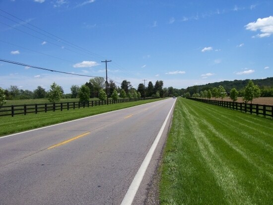
Property Record
Highway 42 E, Warsaw, KY 41095

Property Detail
Highway 42 E
Cincinnati, OH-KY-IN
18.85 ACRES VACANT HWY 42 EAST
017-01.02
GALLATIN
Commercialnec
Kentucky
2025
18.85 AC
2025
Gallatin County
960103
Cincinnati/Dayton
NEARBY LISTINGS FOR SALE OR LEASE
-
-
View all Warsaw listings for sale on LoopNet.com
DEMOGRAPHICS near Highway 42 E
1 mile
3 mile
5 mile
2025 Total Population
1,532
3,590
6,053
2030 Population
1,554
3,628
6,118
Pop Growth 2025-2030
+ 1.44%
+ 1.06%
+ 1.07%
Average Age
39
40
40
2025 Total Households
574
1,366
2,280
HH Growth 2025-2030
+ 1.57%
+ 1.02%
+ 1.05%
Median Household Inc
$63,473
$62,132
$63,038
Avg Household Size
2.50
2.60
2.60
2025 Avg HH Vehicles
2.00
2.00
2.00
Median Home Value
$153,669
$177,816
$181,463
Median Year Built
1992
1990
1992
Nearby Places
Map Layers
Map Styles
 Street
 Aerial
Transit
 Traffic
 Biking
Places
Listings with unknown addresses are not visible on the map
- Restaurants
- Banks
- Shops
- Fitness
- Groceries
PUBLIC TRANSPORTATION
AIRPORT
Cincinnati/Northern Kentucky International
Drive
Walk
Distance
Cincinnati/Northern Kentucky International
49 min
31.7 mi
Freight Ports
Port of Toledo
Drive
Walk
Distance
Port of Toledo
290 min
243.7 mi
Nearby Properties
Address
Land Use
TOTAL SIZE
Lot Size
Zoning
Address
Land Use
TOTAL SIZE
Lot Size
Zoning
28.29 AC
Address
Land Use
TOTAL SIZE
Lot Size
Zoning
101,830 SF
22.14 AC
Address
Land Use
TOTAL SIZE
Lot Size
Zoning
21,000 SF
5.87 AC
Address
Land Use
TOTAL SIZE
Lot Size
Zoning
6,048 SF
7 AC
RESIDENTIA
Address
Land Use
TOTAL SIZE
Lot Size
Zoning
0.55 AC
Address
Land Use
TOTAL SIZE
Lot Size
Zoning
7.32 AC
Address
Land Use
TOTAL SIZE
Lot Size
Zoning
1,456 SF
24.34 AC
RESIDENTIA
Address
Land Use
TOTAL SIZE
Lot Size
Zoning
5.50 AC
Address
Land Use
TOTAL SIZE
Lot Size
Zoning
7,000 SF
1.41 AC
Address
Land Use
TOTAL SIZE
Lot Size
Zoning
1.67 AC
RESIDENTIA
Address
Land Use
TOTAL SIZE
Lot Size
Zoning
0.64 AC
COMMERCIAL
Address
Land Use
TOTAL SIZE
Lot Size
Zoning
23,166 SF
5.20 AC
Address
Land Use
TOTAL SIZE
Lot Size
Zoning
Address
Land Use
TOTAL SIZE
Lot Size
Zoning
2.78 AC
RESIDENTIA
Address
Land Use
TOTAL SIZE
Lot Size
Zoning
31,405 SF
4.84 AC
Address
Land Use
TOTAL SIZE
Lot Size
Zoning
22.80 AC
Address
Land Use
TOTAL SIZE
Lot Size
Zoning
1.55 AC
OTHER
Address
Land Use
TOTAL SIZE
Lot Size
Zoning
11,148 SF
1.98 AC
COMMERCIAL
Address
Land Use
TOTAL SIZE
Lot Size
Zoning
1,896 SF
1.04 AC
RESIDENTIA
Address
Land Use
TOTAL SIZE
Lot Size
Zoning
0.75 AC
Address
Land Use
TOTAL SIZE
Lot Size
Zoning
0.57 AC
COMMERCIAL
Address
Land Use
TOTAL SIZE
Lot Size
Zoning
1.33 AC
Address
Land Use
TOTAL SIZE
Lot Size
Zoning
2,100 SF
105.21 AC
Address
Land Use
TOTAL SIZE
Lot Size
Zoning
5,568 SF
1.79 AC
COMMERCIAL
Address
Land Use
TOTAL SIZE
Lot Size
Zoning
2,479 SF
0.62 AC
RESIDENTIA
Address
Land Use
TOTAL SIZE
Lot Size
Zoning
260.89 AC
Address
Land Use
TOTAL SIZE
Lot Size
Zoning
1.06 AC
Address
Land Use
TOTAL SIZE
Lot Size
Zoning
0.88 AC
Address
Land Use
TOTAL SIZE
Lot Size
Zoning
0.28 AC
The World's #1 Commercial Real Estate Marketplace
Connect with us
© 2026 CoStar Group
The information above has been obtained from sources believed reliable. While we do not doubt its accuracy we have not verified it and make no guarantee, warranty or representation about it. It is your responsibility to independently confirm its accuracy and completeness. Any projections, opinions, assumptions, or estimates used are for example only and do not represent the current or future performance of the property. The value of this transaction to you depends on tax and other factors which should be evaluated by your tax, financial, and legal advisors. You and your advisors should conduct a careful, independent investigation of the property to determine to your satisfaction the suitability of the property for your needs.