Property Record
Highway 431 S, Brownsboro, AL 35741
NEARBY LISTINGS FOR SALE OR LEASE
Property Detail
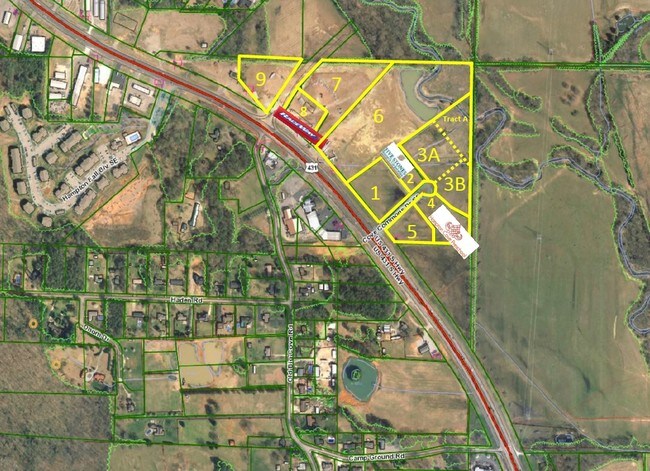
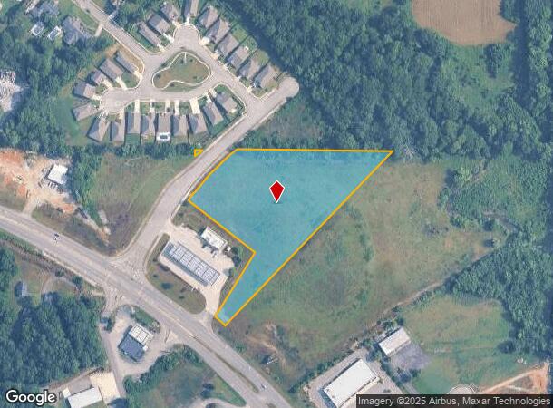
Highway 431 S
18-06-14-0-000-009.005
SEC 14 T4S R1E BEG AT CEN OF W BDRY OF SEC 14 TH E 692 FT TH S44W 851 FT TH N50W 55 FT TH N32E 250 FT NW 280 FT TH NE TO SEC
Commercialacreage
Madison
AE
Alabama
01089C0334F
4.39 AC
2025
South Huntsville
2025
Huntsville
010905
Huntsville, AL
DEMOGRAPHICS near Highway 431 S
1 Mile
3 Mile
5 Mile
2024 Total Population
1,488
15,386
65,959
2029 Population
1,636
16,873
72,601
Pop Growth 2024-2029
+ 9.95%
+ 9.66%
+ 10.07%
Average Age
42
44
43
2024 Total Households
703
6,178
27,956
HH Growth 2024-2029
+ 10.53%
+ 10.02%
+ 10.48%
Median Household Inc
$85,401
$121,313
$103,904
Avg Household Size
2.10
2.40
2.30
2024 Avg HH Vehicles
3.00
2.00
2.00
Median Home Value
$337,500
$367,180
$338,650
Median Year Built
2001
1994
1982
Nearby Places
Map Layers
Map Styles
 Street
 Aerial
- Restaurants
- Banks
- Shops
- Fitness
- Groceries
PUBLIC TRANSPORTATION
AIRPORT
Huntsville International-Carl T Jones Field
DRIVE
WALK
Distance
Huntsville International-Carl T Jones Field
31 min
19.9 mi
Freight Ports
Port of Mobile
DRIVE
WALK
Distance
Port of Mobile
398 min
361.1 mi
SALE & LEASE HISTORY
LISTING DATE
SALE/LEASE

Sep 24, 2016
For Sale
Nearby Properties
Address
Land Use
TOTAL SIZE
Lot Size
Zoning
Address
Land Use
TOTAL SIZE
Lot Size
Zoning
5,136 SF
22 AC
Address
Land Use
TOTAL SIZE
Lot Size
Zoning
3,168 SF
25.32 AC
Address
Land Use
TOTAL SIZE
Lot Size
Zoning
32,879 SF
14 AC
Address
Land Use
TOTAL SIZE
Lot Size
Zoning
29,481 SF
29 AC
Address
Land Use
TOTAL SIZE
Lot Size
Zoning
2,932 SF
36.63 AC
Address
Land Use
TOTAL SIZE
Lot Size
Zoning
3,655 SF
10.75 AC
Address
Land Use
TOTAL SIZE
Lot Size
Zoning
175,364 SF
13.18 AC
Address
Land Use
TOTAL SIZE
Lot Size
Zoning
41,354 SF
2.62 AC
Address
Land Use
TOTAL SIZE
Lot Size
Zoning
183,823 SF
22.23 AC
Address
Land Use
TOTAL SIZE
Lot Size
Zoning
63,648 SF
6.20 AC
Address
Land Use
TOTAL SIZE
Lot Size
Zoning
91,163 SF
15 AC
Address
Land Use
TOTAL SIZE
Lot Size
Zoning
50,716 SF
7.10 AC
Address
Land Use
TOTAL SIZE
Lot Size
Zoning
140,769 SF
14.48 AC
Address
Land Use
TOTAL SIZE
Lot Size
Zoning
70,096 SF
7.38 AC
Address
Land Use
TOTAL SIZE
Lot Size
Zoning
Address
Land Use
TOTAL SIZE
Lot Size
Zoning
7,690 SF
75.26 AC
Address
Land Use
TOTAL SIZE
Lot Size
Zoning
64,700 SF
6.09 AC
Address
Land Use
TOTAL SIZE
Lot Size
Zoning
25,271 SF
2.50 AC
Address
Land Use
TOTAL SIZE
Lot Size
Zoning
2,466 SF
11 AC
Address
Land Use
TOTAL SIZE
Lot Size
Zoning
12,859 SF
8.38 AC
Address
Land Use
TOTAL SIZE
Lot Size
Zoning
1,710 SF
5.65 AC
Address
Land Use
TOTAL SIZE
Lot Size
Zoning
8,788 SF
9.77 AC
Address
Land Use
TOTAL SIZE
Lot Size
Zoning
2,717 SF
6.12 AC
Address
Land Use
TOTAL SIZE
Lot Size
Zoning
6,689 SF
1.30 AC
Address
Land Use
TOTAL SIZE
Lot Size
Zoning
17,345 SF
4.28 AC
Address
Land Use
TOTAL SIZE
Lot Size
Zoning
66,748 SF
3.28 AC
Address
Land Use
TOTAL SIZE
Lot Size
Zoning
42,432 SF
7.71 AC
Address
Land Use
TOTAL SIZE
Lot Size
Zoning
27,359 SF
2.72 AC
Address
Land Use
TOTAL SIZE
Lot Size
Zoning
14,497 SF
1.75 AC
Address
Land Use
TOTAL SIZE
Lot Size
Zoning
13,200 SF
2.40 AC
The World's #1 Commercial Real Estate Marketplace
Connect with us
© 2026 CoStar Group
The information above has been obtained from sources believed reliable. While we do not doubt its accuracy we have not verified it and make no guarantee, warranty or representation about it. It is your responsibility to independently confirm its accuracy and completeness. Any projections, opinions, assumptions, or estimates used are for example only and do not represent the current or future performance of the property. The value of this transaction to you depends on tax and other factors which should be evaluated by your tax, financial, and legal advisors. You and your advisors should conduct a careful, independent investigation of the property to determine to your satisfaction the suitability of the property for your needs.