Property Record
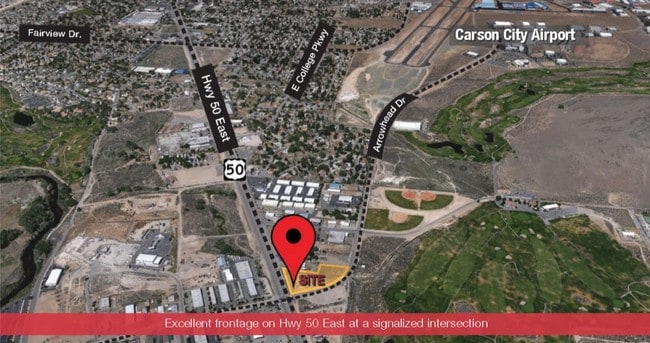
Highway 50 E, Carson City, NV 89706


This Property Is For Sale
Property Detail
Highway 50 E
008-391-13
W OF ARROWHEAD DR
Commercialacreage
CARSON CITY
GI
Nevada
AH Areas with a 1% annual chance of shallow flooding, usually in the form of a pond, withan average depth ranging from 1 to 3 feet. These areas have a 26% chance of flooding over the life of a 30-year mortgage.
2.31 AC
2025
Carson City County
2025
Reno/Sparks
000900
Carson City, NV
NEARBY LISTINGS FOR SALE OR LEASE
DEMOGRAPHICS near Highway 50 E
1 mile
3 mile
5 mile
2025 Total Population
1,128
21,221
53,599
2030 Population
1,108
21,087
53,392
Pop Growth 2025-2030
(1.77%)
(0.63%)
(0.39%)
Average Age
42
41
43
2025 Total Households
412
8,356
21,810
HH Growth 2025-2030
(1.94%)
(0.83%)
(0.41%)
Median Household Inc
$77,009
$67,660
$69,165
Avg Household Size
2.60
2.50
2.30
2025 Avg HH Vehicles
2.00
2.00
2.00
Median Home Value
$375,816
$382,420
$427,986
Median Year Built
1976
1984
1981
Nearby Places
Map Layers
Map Styles
 Street
 Aerial
Layers
 Traffic
 Biking
Places
Listings with unknown addresses are not visible on the map
- Restaurants
- Banks
- Shops
- Fitness
- Groceries
PUBLIC TRANSPORTATION
AIRPORT
Reno/Tahoe International
Drive
Walk
Distance
Reno/Tahoe International
54 min
33.4 mi
Nearby Properties
Address
Land Use
TOTAL SIZE
Lot Size
Zoning
Address
Land Use
TOTAL SIZE
Lot Size
Zoning
356,776 SF
64.42 AC
P
Address
Land Use
TOTAL SIZE
Lot Size
Zoning
7,419 SF
0.71 AC
PR
Address
Land Use
TOTAL SIZE
Lot Size
Zoning
272,519 SF
102.35 AC
P
Address
Land Use
TOTAL SIZE
Lot Size
Zoning
96,057 SF
10 AC
LI
Address
Land Use
TOTAL SIZE
Lot Size
Zoning
213,246 SF
19.48 AC
GC-RC
Address
Land Use
TOTAL SIZE
Lot Size
Zoning
240 AC
PR
Address
Land Use
TOTAL SIZE
Lot Size
Zoning
109,200 SF
9.35 AC
GC
Address
Land Use
TOTAL SIZE
Lot Size
Zoning
89,408 SF
39.22 AC
P
Address
Land Use
TOTAL SIZE
Lot Size
Zoning
29.98 AC
PC
Address
Land Use
TOTAL SIZE
Lot Size
Zoning
375 SF
520 AC
PR
Address
Land Use
TOTAL SIZE
Lot Size
Zoning
178.40 AC
PR
Address
Land Use
TOTAL SIZE
Lot Size
Zoning
156,408 SF
2.08 AC
MFA-GC
Address
Land Use
TOTAL SIZE
Lot Size
Zoning
160,769 SF
15 AC
LI
Address
Land Use
TOTAL SIZE
Lot Size
Zoning
86,783 SF
52 AC
PR
Address
Land Use
TOTAL SIZE
Lot Size
Zoning
20,800 SF
2.90 AC
GC
Address
Land Use
TOTAL SIZE
Lot Size
Zoning
68,342 SF
2.47 AC
TC
Address
Land Use
TOTAL SIZE
Lot Size
Zoning
256.42 AC
Address
Land Use
TOTAL SIZE
Lot Size
Zoning
45,406 SF
5.93 AC
Address
Land Use
TOTAL SIZE
Lot Size
Zoning
107,063 SF
10.96 AC
GC
Address
Land Use
TOTAL SIZE
Lot Size
Zoning
70,763 SF
9.54 AC
P
Address
Land Use
TOTAL SIZE
Lot Size
Zoning
85,751 SF
3.41 AC
Address
Land Use
TOTAL SIZE
Lot Size
Zoning
71,719 SF
1.89 AC
MFA
Address
Land Use
TOTAL SIZE
Lot Size
Zoning
30,481 SF
4.94 AC
Address
Land Use
TOTAL SIZE
Lot Size
Zoning
69,316 SF
2.91 AC
Address
Land Use
TOTAL SIZE
Lot Size
Zoning
80,880 SF
4 AC
Address
Land Use
TOTAL SIZE
Lot Size
Zoning
59,130 SF
10.43 AC
P
Address
Land Use
TOTAL SIZE
Lot Size
Zoning
76,770 SF
2.92 AC
MFA
Address
Land Use
TOTAL SIZE
Lot Size
Zoning
30,228 SF
395.78 AC
PR
Address
Land Use
TOTAL SIZE
Lot Size
Zoning
270 AC
PC
Address
Land Use
TOTAL SIZE
Lot Size
Zoning
3,504 SF
39.83 AC
PR
The World's #1 Commercial Real Estate Marketplace
Connect with us
© 2026 CoStar Group
The information above has been obtained from sources believed reliable. While we do not doubt its accuracy we have not verified it and make no guarantee, warranty or representation about it. It is your responsibility to independently confirm its accuracy and completeness. Any projections, opinions, assumptions, or estimates used are for example only and do not represent the current or future performance of the property. The value of this transaction to you depends on tax and other factors which should be evaluated by your tax, financial, and legal advisors. You and your advisors should conduct a careful, independent investigation of the property to determine to your satisfaction the suitability of the property for your needs.