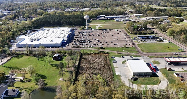
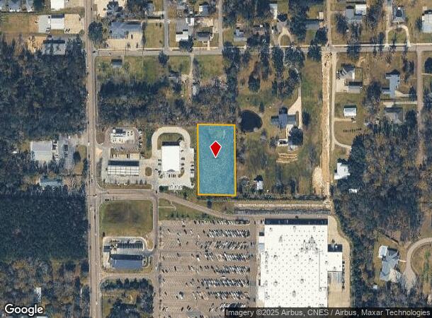
Property Record
Highway 51 N, Ponchatoula, LA 70454
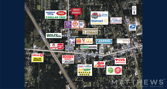
NEARBY LISTINGS FOR SALE OR LEASE
Property Detail
Highway 51 N
Hammond, LA
Wal-Mart Real Estate
06551576
1.36A BEING LOT 2-A-2-B-2 BEING A RESUB OF LOT 2-A OF WAL-MART REAL ESTATE BUSINESS TRUST IN SEC 59 T7SR7E B1559 P399 MAP 128
Commercialnec
Tangipahoa
X
Louisiana
22063C0325E
2
2024
1.36 AC
2024
Louisiana South Area
954601
Other Market Areas
DEMOGRAPHICS near Highway 51 N
1 Mile
3 Mile
5 Mile
2024 Total Population
4,658
21,766
56,128
2029 Population
4,923
23,441
60,617
Pop Growth 2024-2029
+ 5.69%
+ 7.70%
+ 8.00%
Average Age
40
39
38
2024 Total Households
1,869
8,642
21,731
HH Growth 2024-2029
+ 5.51%
+ 7.69%
+ 8.08%
Median Household Inc
$55,395
$53,108
$54,748
Avg Household Size
2.40
2.50
2.40
2024 Avg HH Vehicles
2.00
2.00
2.00
Median Home Value
$201,005
$209,411
$203,222
Median Year Built
2001
2000
1997
Nearby Places
Map Layers
Map Styles
 Street
 Aerial
- Restaurants
- Banks
- Shops
- Fitness
- Groceries
PUBLIC TRANSPORTATION
COMMUTER RAIL
Hammond Amtrak Station (City of New Orleans - Amtrak)
DRIVE
WALK
Distance
Hammond Amtrak Station (City of New Orleans - Amtrak)
7 min
4.5 mi
Freight Ports
Port of New Orleans
DRIVE
WALK
Distance
Port of New Orleans
69 min
54.7 mi
SALE & LEASE HISTORY
LISTING DATE
SALE/LEASE

Mar 31, 2025
For Sale
Jan 28, 2022
For Sale
Nearby Properties
Address
Land Use
TOTAL SIZE
Lot Size
Zoning
Address
Land Use
TOTAL SIZE
Lot Size
Zoning
Address
Land Use
TOTAL SIZE
Lot Size
Zoning
22.56 AC
Address
Land Use
TOTAL SIZE
Lot Size
Zoning
152,841 SF
20.69 AC
Address
Land Use
TOTAL SIZE
Lot Size
Zoning
84,000 SF
8.32 AC
Address
Land Use
TOTAL SIZE
Lot Size
Zoning
82,860 SF
11.42 AC
Address
Land Use
TOTAL SIZE
Lot Size
Zoning
24,931 SF
2.67 AC
Address
Land Use
TOTAL SIZE
Lot Size
Zoning
24,823 SF
3 AC
Address
Land Use
TOTAL SIZE
Lot Size
Zoning
127,380 SF
9.70 AC
Address
Land Use
TOTAL SIZE
Lot Size
Zoning
236,540 SF
36.01 AC
Address
Land Use
TOTAL SIZE
Lot Size
Zoning
36,593 SF
1.54 AC
Address
Land Use
TOTAL SIZE
Lot Size
Zoning
73,922 SF
9.99 AC
Address
Land Use
TOTAL SIZE
Lot Size
Zoning
108,000 SF
9.78 AC
Address
Land Use
TOTAL SIZE
Lot Size
Zoning
22,000 SF
5.56 AC
Address
Land Use
TOTAL SIZE
Lot Size
Zoning
27,215 SF
7.58 AC
Address
Land Use
TOTAL SIZE
Lot Size
Zoning
47,960 SF
9.16 AC
Address
Land Use
TOTAL SIZE
Lot Size
Zoning
96,064 SF
5.03 AC
Address
Land Use
TOTAL SIZE
Lot Size
Zoning
85,430 SF
6.44 AC
Address
Land Use
TOTAL SIZE
Lot Size
Zoning
60,480 SF
7.28 AC
Address
Land Use
TOTAL SIZE
Lot Size
Zoning
20,128 SF
20.77 AC
Address
Land Use
TOTAL SIZE
Lot Size
Zoning
22,507 SF
0.63 AC
Address
Land Use
TOTAL SIZE
Lot Size
Zoning
43,595 SF
10.17 AC
Address
Land Use
TOTAL SIZE
Lot Size
Zoning
90,605 SF
9.76 AC
Address
Land Use
TOTAL SIZE
Lot Size
Zoning
71,300 SF
7.02 AC
Address
Land Use
TOTAL SIZE
Lot Size
Zoning
120,800 SF
10 AC
Address
Land Use
TOTAL SIZE
Lot Size
Zoning
10,753 SF
1.57 AC
Address
Land Use
TOTAL SIZE
Lot Size
Zoning
30,000 SF
7.98 AC
Address
Land Use
TOTAL SIZE
Lot Size
Zoning
61,230 SF
9.79 AC
Address
Land Use
TOTAL SIZE
Lot Size
Zoning
66,281 SF
2.11 AC
Address
Land Use
TOTAL SIZE
Lot Size
Zoning
24,040 SF
2.08 AC
Address
Land Use
TOTAL SIZE
Lot Size
Zoning
56,176 SF
2.02 AC
The World's #1 Commercial Real Estate Marketplace
Connect with us
© 2025 CoStar Group
The information above has been obtained from sources believed reliable. While we do not doubt its accuracy we have not verified it and make no guarantee, warranty or representation about it. It is your responsibility to independently confirm its accuracy and completeness. Any projections, opinions, assumptions, or estimates used are for example only and do not represent the current or future performance of the property. The value of this transaction to you depends on tax and other factors which should be evaluated by your tax, financial, and legal advisors. You and your advisors should conduct a careful, independent investigation of the property to determine to your satisfaction the suitability of the property for your needs.