Property Record
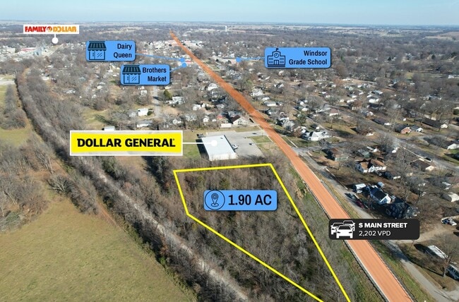
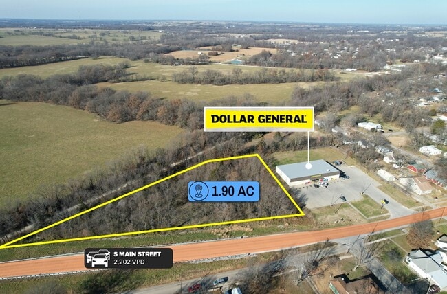
Highway 52, Windsor, MO 65360

This Property Is For Sale
Property Detail
Highway 52
Other Market Areas
LIVINGSTON & WILLOUGHBY'S ADD - WNDSR - ALL OF LTS 3-4-5-6- 7-8-9-10-11 & 12 LY IN NE'4 SEC 11 EXC TR IN NE SIDE(EXC HWY R/W)
10-1.0-11-001-001-002.000
HENRY
Commercialacreage
Missouri
B and X Area of moderate flood hazard, usually the area between the limits of the 100-year and 500-year floods.
3-12
2025
1.90 AC
2025
Missouri South Central Area
950100
NEARBY LISTINGS FOR SALE OR LEASE
-
-
View all Windsor listings for sale on LoopNet.com
DEMOGRAPHICS near Highway 52
1 mile
3 mile
5 mile
2025 Total Population
2,650
3,522
4,085
2030 Population
2,736
3,626
4,201
Pop Growth 2025-2030
+ 3.25%
+ 2.95%
+ 2.84%
Average Age
39
39
40
2025 Total Households
1,047
1,382
1,598
HH Growth 2025-2030
+ 3.44%
+ 3.11%
+ 2.94%
Median Household Inc
$43,124
$45,064
$49,114
Avg Household Size
2.40
2.50
2.50
2025 Avg HH Vehicles
2.00
2.00
2.00
Median Home Value
$111,386
$124,483
$134,684
Median Year Built
1965
1967
1969
Nearby Places
Map Layers
Map Styles
 Street
 Aerial
Transit
 Traffic
 Biking
Places
Listings with unknown addresses are not visible on the map
- Restaurants
- Banks
- Shops
- Fitness
- Groceries
Nearby Properties
Address
Land Use
TOTAL SIZE
Lot Size
Zoning
Address
Land Use
TOTAL SIZE
Lot Size
Zoning
35.50 AC
Address
Land Use
TOTAL SIZE
Lot Size
Zoning
28,955 SF
2.60 AC
Address
Land Use
TOTAL SIZE
Lot Size
Zoning
10,326 SF
32.30 AC
0
Address
Land Use
TOTAL SIZE
Lot Size
Zoning
9,890 SF
1.36 AC
Address
Land Use
TOTAL SIZE
Lot Size
Zoning
3,468 SF
0.33 AC
Address
Land Use
TOTAL SIZE
Lot Size
Zoning
2,401 SF
2.20 AC
Address
Land Use
TOTAL SIZE
Lot Size
Zoning
0.26 AC
Address
Land Use
TOTAL SIZE
Lot Size
Zoning
4,008 SF
1.14 AC
AU
Address
Land Use
TOTAL SIZE
Lot Size
Zoning
3,356 SF
0.81 AC
AP
Address
Land Use
TOTAL SIZE
Lot Size
Zoning
9,230 SF
0.25 AC
Address
Land Use
TOTAL SIZE
Lot Size
Zoning
22,966 SF
9.40 AC
AE
Address
Land Use
TOTAL SIZE
Lot Size
Zoning
20,000 SF
16.10 AC
SA
Address
Land Use
TOTAL SIZE
Lot Size
Zoning
6,910 SF
0.55 AC
Address
Land Use
TOTAL SIZE
Lot Size
Zoning
7,566 SF
1.90 AC
NC
Address
Land Use
TOTAL SIZE
Lot Size
Zoning
9,119 SF
1.30 AC
Address
Land Use
TOTAL SIZE
Lot Size
Zoning
8,111 SF
0.77 AC
Address
Land Use
TOTAL SIZE
Lot Size
Zoning
6,467 SF
11.65 AC
Address
Land Use
TOTAL SIZE
Lot Size
Zoning
6,235 SF
1.10 AC
Address
Land Use
TOTAL SIZE
Lot Size
Zoning
4,224 SF
0.10 AC
Address
Land Use
TOTAL SIZE
Lot Size
Zoning
52,348 SF
8.90 AC
Address
Land Use
TOTAL SIZE
Lot Size
Zoning
Address
Land Use
TOTAL SIZE
Lot Size
Zoning
3,140 SF
5 AC
Address
Land Use
TOTAL SIZE
Lot Size
Zoning
2,563 SF
1.40 AC
AR
Address
Land Use
TOTAL SIZE
Lot Size
Zoning
2,014 SF
0.40 AC
Address
Land Use
TOTAL SIZE
Lot Size
Zoning
1,064 SF
1.03 AC
Address
Land Use
TOTAL SIZE
Lot Size
Zoning
5,200 SF
82 AC
Address
Land Use
TOTAL SIZE
Lot Size
Zoning
0.46 AC
Address
Land Use
TOTAL SIZE
Lot Size
Zoning
9,561 SF
1.40 AC
AR
Address
Land Use
TOTAL SIZE
Lot Size
Zoning
5,521 SF
1 AC
Address
Land Use
TOTAL SIZE
Lot Size
Zoning
2,408 SF
0.19 AC
The World's #1 Commercial Real Estate Marketplace
Connect with us
© 2026 CoStar Group
The information above has been obtained from sources believed reliable. While we do not doubt its accuracy we have not verified it and make no guarantee, warranty or representation about it. It is your responsibility to independently confirm its accuracy and completeness. Any projections, opinions, assumptions, or estimates used are for example only and do not represent the current or future performance of the property. The value of this transaction to you depends on tax and other factors which should be evaluated by your tax, financial, and legal advisors. You and your advisors should conduct a careful, independent investigation of the property to determine to your satisfaction the suitability of the property for your needs.