Property Record
Highway 59, Beasley, TX 77417


Property Detail
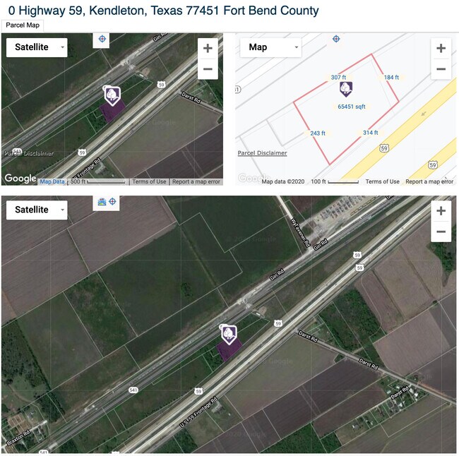
Highway 59
0058-04-700-0010-908
0058 I MCGARY, ACRES 1.49
Residentialacreage
FORT BEND
Z
Texas
B and X Area of moderate flood hazard, usually the area between the limits of the 100-year and 500-year floods.
1.49 AC
2024
Southwest Outlier
2025
Houston
675800
Houston-Pasadena-The Woodlands, TX
NEARBY LISTINGS FOR SALE OR LEASE
DEMOGRAPHICS near Highway 59
1 mile
3 mile
5 mile
2025 Total Population
67
1,271
4,834
2030 Population
76
1,420
5,406
Pop Growth 2025-2030
+ 13.43%
+ 11.72%
+ 11.83%
Average Age
41
41
40
2025 Total Households
24
458
1,693
HH Growth 2025-2030
+ 12.50%
+ 12.01%
+ 11.87%
Median Household Inc
$44,999
$44,360
$55,778
Avg Household Size
2.70
2.70
2.80
2025 Avg HH Vehicles
2.00
2.00
2.00
Median Home Value
$350,000
$318,868
$357,848
Median Year Built
1977
1977
1984
Nearby Places
Map Layers
Map Styles
 Street
 Aerial
Transit
 Traffic
 Biking
Places
Listings with unknown addresses are not visible on the map
- Restaurants
- Banks
- Shops
- Fitness
- Groceries
SALE & LEASE HISTORY
LISTING DATE
SALE/LEASE

Oct 09, 2020
For Sale
Nearby Properties
Address
Land Use
TOTAL SIZE
Lot Size
Zoning
Address
Land Use
TOTAL SIZE
Lot Size
Zoning
828,228 SF
38.96 AC
Address
Land Use
TOTAL SIZE
Lot Size
Zoning
37.55 AC
Address
Land Use
TOTAL SIZE
Lot Size
Zoning
140.86 AC
Address
Land Use
TOTAL SIZE
Lot Size
Zoning
386.32 AC
YSOM
Address
Land Use
TOTAL SIZE
Lot Size
Zoning
77.67 AC
OS
Address
Land Use
TOTAL SIZE
Lot Size
Zoning
41,897 SF
33.03 AC
Address
Land Use
TOTAL SIZE
Lot Size
Zoning
56.70 AC
Z
Address
Land Use
TOTAL SIZE
Lot Size
Zoning
234.20 AC
Address
Land Use
TOTAL SIZE
Lot Size
Zoning
Address
Land Use
TOTAL SIZE
Lot Size
Zoning
22.16 AC
Address
Land Use
TOTAL SIZE
Lot Size
Zoning
25 AC
R
Address
Land Use
TOTAL SIZE
Lot Size
Zoning
45.44 AC
OS
Address
Land Use
TOTAL SIZE
Lot Size
Zoning
2,304 SF
81.04 AC
TS
Address
Land Use
TOTAL SIZE
Lot Size
Zoning
5,695 SF
75 AC
Address
Land Use
TOTAL SIZE
Lot Size
Zoning
1,500 SF
0.32 AC
X
Address
Land Use
TOTAL SIZE
Lot Size
Zoning
4,079 SF
6.70 AC
Address
Land Use
TOTAL SIZE
Lot Size
Zoning
235.17 AC
T
Address
Land Use
TOTAL SIZE
Lot Size
Zoning
50.17 AC
Address
Land Use
TOTAL SIZE
Lot Size
Zoning
14,570 SF
29.56 AC
Address
Land Use
TOTAL SIZE
Lot Size
Zoning
15.41 AC
Address
Land Use
TOTAL SIZE
Lot Size
Zoning
5,000 SF
1.60 AC
Address
Land Use
TOTAL SIZE
Lot Size
Zoning
4.65 AC
Address
Land Use
TOTAL SIZE
Lot Size
Zoning
Address
Land Use
TOTAL SIZE
Lot Size
Zoning
2,881 SF
0.15 AC
Address
Land Use
TOTAL SIZE
Lot Size
Zoning
5,850 SF
2 AC
Address
Land Use
TOTAL SIZE
Lot Size
Zoning
34.34 AC
Address
Land Use
TOTAL SIZE
Lot Size
Zoning
0.16 AC
Address
Land Use
TOTAL SIZE
Lot Size
Zoning
2,651 SF
0.16 AC
Address
Land Use
TOTAL SIZE
Lot Size
Zoning
2,813 SF
10.14 AC
R
Address
Land Use
TOTAL SIZE
Lot Size
Zoning
The World's #1 Commercial Real Estate Marketplace
Connect with us
© 2026 CoStar Group
The information above has been obtained from sources believed reliable. While we do not doubt its accuracy we have not verified it and make no guarantee, warranty or representation about it. It is your responsibility to independently confirm its accuracy and completeness. Any projections, opinions, assumptions, or estimates used are for example only and do not represent the current or future performance of the property. The value of this transaction to you depends on tax and other factors which should be evaluated by your tax, financial, and legal advisors. You and your advisors should conduct a careful, independent investigation of the property to determine to your satisfaction the suitability of the property for your needs.