Property Record
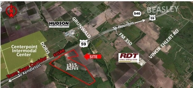
Highway 59, Rosenberg, TX 77471

Property Detail
Highway 59
Houston-Pasadena-The Woodlands, TX
0126 BBB AND C RY, TRACT 1 (PT), ACRES 48.6905, PART OF A 375 ACRE TRACT, 97% IN M315, 1% IN M316, 1% IN M317, 1% IN M318
0126-00-309-0021-901
FORT BEND
Commercialnec
Texas
OS
2
A Areas with a 1% annual chance of flooding and a 26% chance of flooding over the life of a 30-year mortgage.
77.67 AC
2024
Southwest Outlier
2025
Houston
675300
NEARBY LISTINGS FOR SALE OR LEASE
DEMOGRAPHICS near Highway 59
1 mile
3 mile
5 mile
2025 Total Population
497
2,863
5,641
2030 Population
575
3,309
6,433
Pop Growth 2025-2030
+ 15.69%
+ 15.58%
+ 14.04%
Average Age
41
39
40
2025 Total Households
172
960
1,911
HH Growth 2025-2030
+ 16.28%
+ 16.04%
+ 14.29%
Median Household Inc
$42,500
$56,323
$57,239
Avg Household Size
2.80
3.00
2.90
2025 Avg HH Vehicles
2.00
2.00
2.00
Median Home Value
$548,611
$473,255
$372,972
Median Year Built
1991
1988
1986
Nearby Places
Map Layers
Map Styles
 Street
 Aerial
Layers
 Traffic
 Biking
Places
Listings with unknown addresses are not visible on the map
- Restaurants
- Banks
- Shops
- Fitness
- Groceries
Nearby Properties
Address
Land Use
TOTAL SIZE
Lot Size
Zoning
Address
Land Use
TOTAL SIZE
Lot Size
Zoning
100,000 SF
1.32 AC
Address
Land Use
TOTAL SIZE
Lot Size
Zoning
828,228 SF
38.96 AC
Address
Land Use
TOTAL SIZE
Lot Size
Zoning
37.55 AC
Address
Land Use
TOTAL SIZE
Lot Size
Zoning
110,714 SF
14.34 AC
Address
Land Use
TOTAL SIZE
Lot Size
Zoning
159.79 AC
OTYM
Address
Land Use
TOTAL SIZE
Lot Size
Zoning
21.35 AC
S
Address
Land Use
TOTAL SIZE
Lot Size
Zoning
Address
Land Use
TOTAL SIZE
Lot Size
Zoning
140.86 AC
Address
Land Use
TOTAL SIZE
Lot Size
Zoning
386.32 AC
YSOM
Address
Land Use
TOTAL SIZE
Lot Size
Zoning
13,200 SF
2.20 AC
S
Address
Land Use
TOTAL SIZE
Lot Size
Zoning
13,920 SF
3 AC
SM
Address
Land Use
TOTAL SIZE
Lot Size
Zoning
56.70 AC
Z
Address
Land Use
TOTAL SIZE
Lot Size
Zoning
47,860 SF
4 AC
YS
Address
Land Use
TOTAL SIZE
Lot Size
Zoning
44,400 SF
70.82 AC
O
Address
Land Use
TOTAL SIZE
Lot Size
Zoning
41,500 SF
5 AC
Address
Land Use
TOTAL SIZE
Lot Size
Zoning
234.20 AC
Address
Land Use
TOTAL SIZE
Lot Size
Zoning
800 SF
89.75 AC
OTS
Address
Land Use
TOTAL SIZE
Lot Size
Zoning
6,891 SF
4.01 AC
XY
Address
Land Use
TOTAL SIZE
Lot Size
Zoning
11,820 SF
2.57 AC
MY
Address
Land Use
TOTAL SIZE
Lot Size
Zoning
22.16 AC
Address
Land Use
TOTAL SIZE
Lot Size
Zoning
25 AC
R
Address
Land Use
TOTAL SIZE
Lot Size
Zoning
58.43 AC
SYO
Address
Land Use
TOTAL SIZE
Lot Size
Zoning
784 SF
1.67 AC
X
Address
Land Use
TOTAL SIZE
Lot Size
Zoning
83.29 AC
YS
Address
Land Use
TOTAL SIZE
Lot Size
Zoning
99.90 AC
Address
Land Use
TOTAL SIZE
Lot Size
Zoning
57,600 SF
2.65 AC
Address
Land Use
TOTAL SIZE
Lot Size
Zoning
45.44 AC
OS
Address
Land Use
TOTAL SIZE
Lot Size
Zoning
36.56 AC
SL
Address
Land Use
TOTAL SIZE
Lot Size
Zoning
789 SF
46.19 AC
The World's #1 Commercial Real Estate Marketplace
Connect with us
© 2026 CoStar Group
The information above has been obtained from sources believed reliable. While we do not doubt its accuracy we have not verified it and make no guarantee, warranty or representation about it. It is your responsibility to independently confirm its accuracy and completeness. Any projections, opinions, assumptions, or estimates used are for example only and do not represent the current or future performance of the property. The value of this transaction to you depends on tax and other factors which should be evaluated by your tax, financial, and legal advisors. You and your advisors should conduct a careful, independent investigation of the property to determine to your satisfaction the suitability of the property for your needs.