Property Record
Highway 59, Splendora, TX 77372
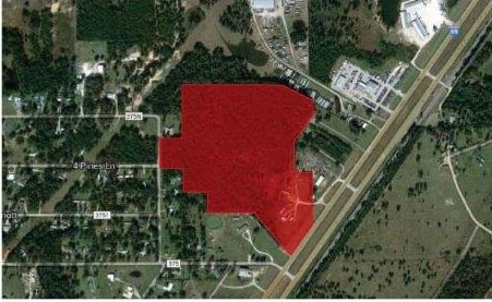

Property Detail
Highway 59
Houston-Pasadena-The Woodlands, TX
000306 M B LAWRENCE, TRACT 91, ACRES 2.25
000306-000018-007
LIBERTY
Commercialnec
Texas
B and X Area of moderate flood hazard, usually the area between the limits of the 100-year and 500-year floods.
91
2024
17.34 AC
2025
Liberty County
200104
Houston
640 SF
NEARBY LISTINGS FOR SALE OR LEASE
DEMOGRAPHICS near Highway 59
1 mile
3 mile
5 mile
2025 Total Population
2,555
11,634
29,711
2030 Population
3,057
13,847
35,639
Pop Growth 2025-2030
+ 19.65%
+ 19.02%
+ 19.95%
Average Age
35
36
35
2025 Total Households
807
3,714
9,407
HH Growth 2025-2030
+ 19.58%
+ 19.20%
+ 19.96%
Median Household Inc
$71,553
$71,213
$70,612
Avg Household Size
3.00
3.00
3.10
2025 Avg HH Vehicles
2.00
2.00
2.00
Median Home Value
$201,326
$226,740
$224,571
Median Year Built
1997
1998
1998
Nearby Places
Map Layers
Map Styles
 Street
 Aerial
Layers
 Traffic
 Biking
Places
Listings with unknown addresses are not visible on the map
- Restaurants
- Banks
- Shops
- Fitness
- Groceries
PUBLIC TRANSPORTATION
AIRPORT
George Bush Intcntl/Houston
Drive
Walk
Distance
George Bush Intcntl/Houston
35 min
29.3 mi
Freight Ports
Port of Houston
Drive
Walk
Distance
Port of Houston
57 min
44.6 mi
Nearby Properties
Address
Land Use
TOTAL SIZE
Lot Size
Zoning
Address
Land Use
TOTAL SIZE
Lot Size
Zoning
84,249 SF
38.34 AC
Address
Land Use
TOTAL SIZE
Lot Size
Zoning
78,721 SF
22.26 AC
Address
Land Use
TOTAL SIZE
Lot Size
Zoning
30,916 SF
3.36 AC
Address
Land Use
TOTAL SIZE
Lot Size
Zoning
40,592 SF
33.55 AC
Address
Land Use
TOTAL SIZE
Lot Size
Zoning
32,600 SF
9.21 AC
5
Address
Land Use
TOTAL SIZE
Lot Size
Zoning
12,634 SF
4.74 AC
Address
Land Use
TOTAL SIZE
Lot Size
Zoning
44,160 SF
10.98 AC
5
Address
Land Use
TOTAL SIZE
Lot Size
Zoning
93,030 SF
7.22 AC
Address
Land Use
TOTAL SIZE
Lot Size
Zoning
10,640 SF
1.13 AC
Address
Land Use
TOTAL SIZE
Lot Size
Zoning
7,000 SF
4.51 AC
Address
Land Use
TOTAL SIZE
Lot Size
Zoning
17,158 SF
11.25 AC
Address
Land Use
TOTAL SIZE
Lot Size
Zoning
9,740 SF
8.08 AC
5
Address
Land Use
TOTAL SIZE
Lot Size
Zoning
5,279 SF
11.33 AC
5
Address
Land Use
TOTAL SIZE
Lot Size
Zoning
6,193 SF
4.84 AC
5
Address
Land Use
TOTAL SIZE
Lot Size
Zoning
31,430 SF
1.43 AC
Address
Land Use
TOTAL SIZE
Lot Size
Zoning
25,300 SF
5.13 AC
Address
Land Use
TOTAL SIZE
Lot Size
Zoning
49.40 AC
5
Address
Land Use
TOTAL SIZE
Lot Size
Zoning
9,000 SF
1.93 AC
Address
Land Use
TOTAL SIZE
Lot Size
Zoning
5.02 AC
5
Address
Land Use
TOTAL SIZE
Lot Size
Zoning
22,000 SF
3.01 AC
5
Address
Land Use
TOTAL SIZE
Lot Size
Zoning
28,572 SF
3.58 AC
5
Address
Land Use
TOTAL SIZE
Lot Size
Zoning
32,154 SF
3.16 AC
Address
Land Use
TOTAL SIZE
Lot Size
Zoning
22,900 SF
4.30 AC
5
Address
Land Use
TOTAL SIZE
Lot Size
Zoning
4,680 SF
5.19 AC
5
Address
Land Use
TOTAL SIZE
Lot Size
Zoning
5,152 SF
1.86 AC
Address
Land Use
TOTAL SIZE
Lot Size
Zoning
14,000 SF
3 AC
Address
Land Use
TOTAL SIZE
Lot Size
Zoning
3,866 SF
49.73 AC
Address
Land Use
TOTAL SIZE
Lot Size
Zoning
22,940 SF
7.56 AC
5
The World's #1 Commercial Real Estate Marketplace
Connect with us
© 2026 CoStar Group
The information above has been obtained from sources believed reliable. While we do not doubt its accuracy we have not verified it and make no guarantee, warranty or representation about it. It is your responsibility to independently confirm its accuracy and completeness. Any projections, opinions, assumptions, or estimates used are for example only and do not represent the current or future performance of the property. The value of this transaction to you depends on tax and other factors which should be evaluated by your tax, financial, and legal advisors. You and your advisors should conduct a careful, independent investigation of the property to determine to your satisfaction the suitability of the property for your needs.