Property Record
Highway 6, Manvel, TX 77578
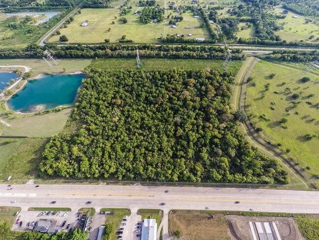

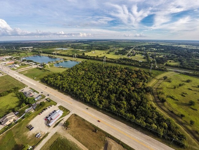
Property Detail
Highway 6
Houston-Pasadena-The Woodlands, TX
A0285 H T & B R R TRACT 201-202-205-206 ACRES 14.4777
0285-0026-010
BRAZORIA
Agriculturalland
Texas
AO River or stream flood hazard areas, and areas with a 1% or greater chance of shallow flooding each year. These areas have a 26% chance of flooding over the life of a 30-year mortgage.
14.48 AC
2024
South Hwy 35
2025
Houston
660702
NEARBY LISTINGS FOR SALE OR LEASE
DEMOGRAPHICS near Highway 6
1 mile
3 mile
5 mile
2025 Total Population
389
21,091
86,975
2030 Population
446
23,951
98,410
Pop Growth 2025-2030
+ 14.65%
+ 13.56%
+ 13.15%
Average Age
39
36
35
2025 Total Households
134
6,788
27,376
HH Growth 2025-2030
+ 14.18%
+ 13.86%
+ 13.35%
Median Household Inc
$129,762
$120,423
$116,232
Avg Household Size
2.80
3.10
3.10
2025 Avg HH Vehicles
2.00
2.00
2.00
Median Home Value
$417,647
$360,438
$358,961
Median Year Built
2010
2010
2010
Nearby Places
Map Layers
Map Styles
 Street
 Aerial
Layers
 Traffic
 Biking
Places
Listings with unknown addresses are not visible on the map
- Restaurants
- Banks
- Shops
- Fitness
- Groceries
PUBLIC TRANSPORTATION
AIRPORT
William P Hobby
Drive
Walk
Distance
William P Hobby
37 min
21.2 mi
Freight Ports
Port of Houston
Drive
Walk
Distance
Port of Houston
42 min
28.0 mi
SALE & LEASE HISTORY
LISTING DATE
SALE/LEASE

Sep 24, 2016
For Sale
May 26, 2022
For Sale
Mar 20, 2017
For Sale
Nearby Properties
Address
Land Use
TOTAL SIZE
Lot Size
Zoning
Address
Land Use
TOTAL SIZE
Lot Size
Zoning
114.04 AC
Address
Land Use
TOTAL SIZE
Lot Size
Zoning
125,750 SF
28.32 AC
Address
Land Use
TOTAL SIZE
Lot Size
Zoning
115,423 SF
12.13 AC
Address
Land Use
TOTAL SIZE
Lot Size
Zoning
120,380 SF
15.56 AC
Address
Land Use
TOTAL SIZE
Lot Size
Zoning
93,990 SF
15.73 AC
Address
Land Use
TOTAL SIZE
Lot Size
Zoning
121,138 SF
11.52 AC
Address
Land Use
TOTAL SIZE
Lot Size
Zoning
21.99 AC
0258
Address
Land Use
TOTAL SIZE
Lot Size
Zoning
65,012 SF
13 AC
Address
Land Use
TOTAL SIZE
Lot Size
Zoning
70,033 SF
17.97 AC
Address
Land Use
TOTAL SIZE
Lot Size
Zoning
15.28 AC
0015
Address
Land Use
TOTAL SIZE
Lot Size
Zoning
17.17 AC
Address
Land Use
TOTAL SIZE
Lot Size
Zoning
67,748 SF
9.28 AC
Address
Land Use
TOTAL SIZE
Lot Size
Zoning
28,708 SF
9.57 AC
Address
Land Use
TOTAL SIZE
Lot Size
Zoning
46,732 SF
8.64 AC
0752
Address
Land Use
TOTAL SIZE
Lot Size
Zoning
44,735 SF
120.87 AC
0010
Address
Land Use
TOTAL SIZE
Lot Size
Zoning
214,827 SF
15.70 AC
0033
Address
Land Use
TOTAL SIZE
Lot Size
Zoning
94,094 SF
5.86 AC
Address
Land Use
TOTAL SIZE
Lot Size
Zoning
98,957 SF
10.70 AC
Address
Land Use
TOTAL SIZE
Lot Size
Zoning
75,548 SF
12.30 AC
Address
Land Use
TOTAL SIZE
Lot Size
Zoning
9,030 SF
20.41 AC
Address
Land Use
TOTAL SIZE
Lot Size
Zoning
114,723 SF
20.13 AC
0007
Address
Land Use
TOTAL SIZE
Lot Size
Zoning
21,300 SF
12.92 AC
Address
Land Use
TOTAL SIZE
Lot Size
Zoning
11,628 SF
1.86 AC
0009
Address
Land Use
TOTAL SIZE
Lot Size
Zoning
48,750 SF
2.82 AC
Address
Land Use
TOTAL SIZE
Lot Size
Zoning
14,575 SF
2.13 AC
Address
Land Use
TOTAL SIZE
Lot Size
Zoning
50,400 SF
8.40 AC
0013
Address
Land Use
TOTAL SIZE
Lot Size
Zoning
29,625 SF
2.01 AC
Address
Land Use
TOTAL SIZE
Lot Size
Zoning
36,504 SF
10 AC
0031
Address
Land Use
TOTAL SIZE
Lot Size
Zoning
16,512 SF
3.04 AC
Address
Land Use
TOTAL SIZE
Lot Size
Zoning
14,768 SF
1.30 AC
The World's #1 Commercial Real Estate Marketplace
Connect with us
© 2026 CoStar Group
The information above has been obtained from sources believed reliable. While we do not doubt its accuracy we have not verified it and make no guarantee, warranty or representation about it. It is your responsibility to independently confirm its accuracy and completeness. Any projections, opinions, assumptions, or estimates used are for example only and do not represent the current or future performance of the property. The value of this transaction to you depends on tax and other factors which should be evaluated by your tax, financial, and legal advisors. You and your advisors should conduct a careful, independent investigation of the property to determine to your satisfaction the suitability of the property for your needs.