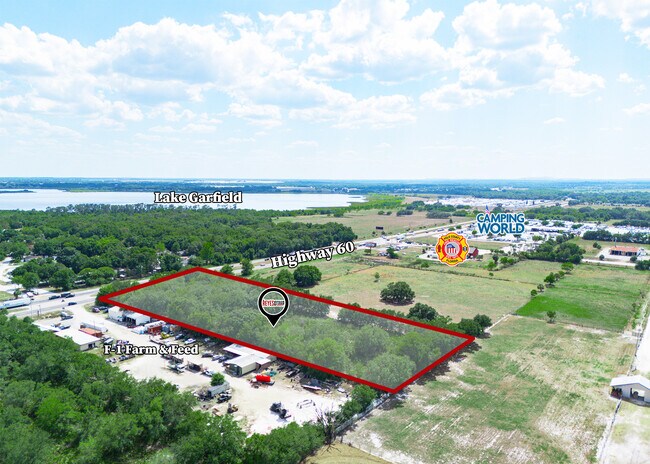
Property Record
Highway 60 E, Bartow, FL 33830


Save to a Folder
{{folder.Name}}
{{folder.ListingIds.length}} Properties
{{folder.ListingIds.length}} Property
Create a New Folder
Property Detail
Highway 60 E
Lakeland-Winter Haven, FL
W 200 FT OF THE FOLLOWING NW1/4 LYING N OF SR 60 LESS W 995.64 FT & LESS N 1960 FT & LESS GARDENIA SUB & LESS S 200 FT OF E 200 FT W OF GARDENIA SUB
26-29-33-000000-034090
POLK
Industrialacreage
Florida
B and X Area of moderate flood hazard, usually the area between the limits of the 100-year and 500-year floods.
3.01 AC
2025
Polk County
2025
Tampa/St Petersburg
015200
NEARBY LISTINGS FOR SALE OR LEASE
DEMOGRAPHICS near Highway 60 E
1 mile
3 mile
5 mile
2025 Total Population
1,006
9,327
37,871
2030 Population
1,153
10,651
43,672
Pop Growth 2025-2030
+ 14.61%
+ 14.20%
+ 15.32%
Average Age
40
38
41
2025 Total Households
367
3,179
13,722
HH Growth 2025-2030
+ 14.71%
+ 14.50%
+ 15.60%
Median Household Inc
$60,187
$58,244
$69,468
Avg Household Size
2.70
2.90
2.70
2025 Avg HH Vehicles
2.00
2.00
2.00
Median Home Value
$242,623
$214,268
$314,184
Median Year Built
1994
1988
2001
Nearby Places
Map Layers
Map Styles
 Street
 Aerial
Layers
 Traffic
 Biking
Places
Listings with unknown addresses are not visible on the map
- Restaurants
- Banks
- Shops
- Fitness
- Groceries
PUBLIC TRANSPORTATION
COMMUTER RAIL
Winter Haven (Silver Meteor - Amtrak, Silver Star - Amtrak)
Drive
Walk
Distance
Winter Haven (Silver Meteor - Amtrak, Silver Star - Amtrak)
11 min
6.5 mi
Freight Ports
Port of Tampa Bay
Drive
Walk
Distance
Port of Tampa Bay
70 min
48.0 mi
Nearby Properties
Address
Land Use
TOTAL SIZE
Lot Size
Zoning
Address
Land Use
TOTAL SIZE
Lot Size
Zoning
1,221,145 SF
179.12 AC
Address
Land Use
TOTAL SIZE
Lot Size
Zoning
407,400 SF
22.33 AC
Address
Land Use
TOTAL SIZE
Lot Size
Zoning
332,360 SF
72.50 AC
Address
Land Use
TOTAL SIZE
Lot Size
Zoning
39,428 SF
20.02 AC
Address
Land Use
TOTAL SIZE
Lot Size
Zoning
29,703 SF
36.18 AC
C4
Address
Land Use
TOTAL SIZE
Lot Size
Zoning
Address
Land Use
TOTAL SIZE
Lot Size
Zoning
66,774 SF
9.20 AC
Address
Land Use
TOTAL SIZE
Lot Size
Zoning
7,794 SF
8.55 AC
Address
Land Use
TOTAL SIZE
Lot Size
Zoning
10,208 SF
191.69 AC
Address
Land Use
TOTAL SIZE
Lot Size
Zoning
81,564 SF
5.91 AC
Address
Land Use
TOTAL SIZE
Lot Size
Zoning
24,149 SF
8.73 AC
Address
Land Use
TOTAL SIZE
Lot Size
Zoning
5,696 SF
2.60 AC
Address
Land Use
TOTAL SIZE
Lot Size
Zoning
134.65 AC
Address
Land Use
TOTAL SIZE
Lot Size
Zoning
8,116 SF
8.09 AC
Address
Land Use
TOTAL SIZE
Lot Size
Zoning
6,970 SF
72.60 AC
Address
Land Use
TOTAL SIZE
Lot Size
Zoning
41.32 AC
Address
Land Use
TOTAL SIZE
Lot Size
Zoning
Address
Land Use
TOTAL SIZE
Lot Size
Zoning
8,029 SF
2 AC
Address
Land Use
TOTAL SIZE
Lot Size
Zoning
77.47 AC
Address
Land Use
TOTAL SIZE
Lot Size
Zoning
3,071 SF
6.41 AC
RE2
Address
Land Use
TOTAL SIZE
Lot Size
Zoning
Address
Land Use
TOTAL SIZE
Lot Size
Zoning
8,656 SF
1.53 AC
Address
Land Use
TOTAL SIZE
Lot Size
Zoning
23,940 SF
9.51 AC
RE2
Address
Land Use
TOTAL SIZE
Lot Size
Zoning
9,490 SF
3.54 AC
R3
Address
Land Use
TOTAL SIZE
Lot Size
Zoning
7,944 SF
1.55 AC
Address
Land Use
TOTAL SIZE
Lot Size
Zoning
32.03 AC
Address
Land Use
TOTAL SIZE
Lot Size
Zoning
14,000 SF
1.22 AC
Address
Land Use
TOTAL SIZE
Lot Size
Zoning
Address
Land Use
TOTAL SIZE
Lot Size
Zoning
8,740 SF
1.55 AC
LI
Address
Land Use
TOTAL SIZE
Lot Size
Zoning
15,576 SF
3.04 AC
The World's #1 Commercial Real Estate Marketplace
Connect with us
© 2026 CoStar Group
The information above has been obtained from sources believed reliable. While we do not doubt its accuracy we have not verified it and make no guarantee, warranty or representation about it. It is your responsibility to independently confirm its accuracy and completeness. Any projections, opinions, assumptions, or estimates used are for example only and do not represent the current or future performance of the property. The value of this transaction to you depends on tax and other factors which should be evaluated by your tax, financial, and legal advisors. You and your advisors should conduct a careful, independent investigation of the property to determine to your satisfaction the suitability of the property for your needs.