Property Record
Highway 62, Mountain Home, AR 72653

Property Detail
Highway 62
Mountain Home, AR
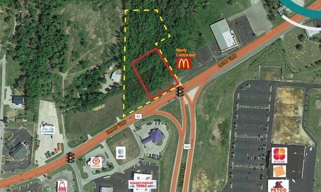
PART OF THE NORTHEAST QUARTER (NE1/4) OF THE SOUTHEAST QUARTER (SE1/4), SECTION 35 TOWNSHIP 20 NORTH, RANGE 13 WEST, BAXTER COUNTY, ARKANSAS, MORE SPECIFICALLY, DESCRIBED AS FOLLOWS: BEGINNING AT THE NORTHWEST CORNER OF THE NE1/4 SE 1/4, THENCE ALONG
007-15001-000
BAXTER
Commercialacreage
Arkansas
B and X Area of moderate flood hazard, usually the area between the limits of the 100-year and 500-year floods.
4.22 AC
2025
Arkansas North Area
2025
Other Market Areas
950200
NEARBY LISTINGS FOR SALE OR LEASE
-
-
View all Mountain Home listings for lease on LoopNet.com
DEMOGRAPHICS near Highway 62
1 mile
3 mile
5 mile
2025 Total Population
1,014
11,160
20,851
2030 Population
1,022
11,243
21,106
Pop Growth 2025-2030
+ 0.79%
+ 0.74%
+ 1.22%
Average Age
50
47
47
2025 Total Households
483
5,277
9,697
HH Growth 2025-2030
+ 0.83%
+ 0.76%
+ 1.26%
Median Household Inc
$48,683
$43,686
$45,796
Avg Household Size
2.00
2.10
2.10
2025 Avg HH Vehicles
2.00
2.00
2.00
Median Home Value
$175,489
$173,547
$179,348
Median Year Built
1982
1981
1981
Nearby Places
Map Layers
Map Styles
 Street
 Aerial
Layers
 Traffic
 Biking
Places
Listings with unknown addresses are not visible on the map
- Restaurants
- Banks
- Shops
- Fitness
- Groceries
SALE & LEASE HISTORY
LISTING DATE
SALE/LEASE

Sep 16, 2020
For Lease
Sep 16, 2020
For Sale
Nearby Properties
Address
Land Use
TOTAL SIZE
Lot Size
Zoning
Address
Land Use
TOTAL SIZE
Lot Size
Zoning
220,476 SF
24.47 AC
Address
Land Use
TOTAL SIZE
Lot Size
Zoning
75,518 SF
24.82 AC
Address
Land Use
TOTAL SIZE
Lot Size
Zoning
74,848 SF
7.90 AC
Address
Land Use
TOTAL SIZE
Lot Size
Zoning
124,870 SF
9.73 AC
Address
Land Use
TOTAL SIZE
Lot Size
Zoning
136,734 SF
11.63 AC
Address
Land Use
TOTAL SIZE
Lot Size
Zoning
99,747 SF
11.20 AC
Address
Land Use
TOTAL SIZE
Lot Size
Zoning
9,440 SF
5 AC
Address
Land Use
TOTAL SIZE
Lot Size
Zoning
12,575 SF
12.05 AC
Address
Land Use
TOTAL SIZE
Lot Size
Zoning
105,500 SF
19.58 AC
Address
Land Use
TOTAL SIZE
Lot Size
Zoning
66,209 SF
6.68 AC
Address
Land Use
TOTAL SIZE
Lot Size
Zoning
56,514 SF
6.14 AC
Address
Land Use
TOTAL SIZE
Lot Size
Zoning
35,280 SF
4.69 AC
Address
Land Use
TOTAL SIZE
Lot Size
Zoning
20,277 SF
0.44 AC
Address
Land Use
TOTAL SIZE
Lot Size
Zoning
37,603 SF
2.16 AC
Address
Land Use
TOTAL SIZE
Lot Size
Zoning
42,060 SF
2.26 AC
Address
Land Use
TOTAL SIZE
Lot Size
Zoning
12,000 SF
45.78 AC
Address
Land Use
TOTAL SIZE
Lot Size
Zoning
3,850 SF
1.55 AC
Address
Land Use
TOTAL SIZE
Lot Size
Zoning
26,510 SF
1.47 AC
Address
Land Use
TOTAL SIZE
Lot Size
Zoning
54,846 SF
5.42 AC
Address
Land Use
TOTAL SIZE
Lot Size
Zoning
35,960 SF
2.86 AC
Address
Land Use
TOTAL SIZE
Lot Size
Zoning
54,800 SF
2.51 AC
Address
Land Use
TOTAL SIZE
Lot Size
Zoning
17,980 SF
2.72 AC
Address
Land Use
TOTAL SIZE
Lot Size
Zoning
5,040 SF
0.98 AC
Address
Land Use
TOTAL SIZE
Lot Size
Zoning
19,390 SF
5.18 AC
Address
Land Use
TOTAL SIZE
Lot Size
Zoning
14,686 SF
1.60 AC
Address
Land Use
TOTAL SIZE
Lot Size
Zoning
23,883 SF
8.28 AC
Address
Land Use
TOTAL SIZE
Lot Size
Zoning
2,258 SF
4.34 AC
Address
Land Use
TOTAL SIZE
Lot Size
Zoning
50,922 SF
6.57 AC
Address
Land Use
TOTAL SIZE
Lot Size
Zoning
46,770 SF
14.53 AC
Address
Land Use
TOTAL SIZE
Lot Size
Zoning
24,226 SF
5.36 AC
The World's #1 Commercial Real Estate Marketplace
Connect with us
© 2026 CoStar Group
The information above has been obtained from sources believed reliable. While we do not doubt its accuracy we have not verified it and make no guarantee, warranty or representation about it. It is your responsibility to independently confirm its accuracy and completeness. Any projections, opinions, assumptions, or estimates used are for example only and do not represent the current or future performance of the property. The value of this transaction to you depends on tax and other factors which should be evaluated by your tax, financial, and legal advisors. You and your advisors should conduct a careful, independent investigation of the property to determine to your satisfaction the suitability of the property for your needs.