Property Record
Highway 65, Conway, AR 72032
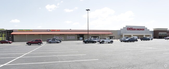

Property Detail
Highway 65
710-08185-000C
PT E 1/2 SW
Regionalshoppingcenterormallwithanchorstore
FAULKNER
B and X Area of moderate flood hazard, usually the area between the limits of the 100-year and 500-year floods.
Arkansas
2025
6.90 AC
2025
Faulkner County
030404
Little Rock/N Little Rock
102,616 SF
Little Rock-North Little Rock-Conway, AR
NEARBY LISTINGS FOR SALE OR LEASE
DEMOGRAPHICS near Highway 65
1 mile
3 mile
5 mile
2025 Total Population
2,243
35,733
70,515
2030 Population
2,375
37,742
74,260
Pop Growth 2025-2030
+ 5.88%
+ 5.62%
+ 5.31%
Average Age
37
36
36
2025 Total Households
831
14,240
27,850
HH Growth 2025-2030
+ 6.14%
+ 5.94%
+ 5.67%
Median Household Inc
$74,999
$61,146
$64,663
Avg Household Size
2.30
2.30
2.30
2025 Avg HH Vehicles
2.00
2.00
2.00
Median Home Value
$277,350
$222,169
$250,346
Median Year Built
1993
1991
1996
Nearby Places
Map Layers
Map Styles
 Street
 Aerial
Transit
 Traffic
 Biking
Places
Listings with unknown addresses are not visible on the map
- Restaurants
- Banks
- Shops
- Fitness
- Groceries
PUBLIC TRANSPORTATION
AIRPORT
Bill and Hillary Clinton Ntl/Adams Field
Drive
Walk
Distance
Bill and Hillary Clinton Ntl/Adams Field
41 min
35.5 mi
Freight Ports
Tulsa Port of Inola
Drive
Walk
Distance
Tulsa Port of Inola
252 min
229.7 mi
SALE & LEASE HISTORY
LISTING DATE
SALE/LEASE

Sep 25, 2016
For Lease
Nearby Properties
Address
Land Use
TOTAL SIZE
Lot Size
Zoning
Address
Land Use
TOTAL SIZE
Lot Size
Zoning
123,032 SF
9.59 AC
Address
Land Use
TOTAL SIZE
Lot Size
Zoning
164,655 SF
10.36 AC
Address
Land Use
TOTAL SIZE
Lot Size
Zoning
107,636 SF
Address
Land Use
TOTAL SIZE
Lot Size
Zoning
38,442 SF
30.57 AC
Address
Land Use
TOTAL SIZE
Lot Size
Zoning
21,664 SF
13.85 AC
Address
Land Use
TOTAL SIZE
Lot Size
Zoning
29,223 SF
8.88 AC
Address
Land Use
TOTAL SIZE
Lot Size
Zoning
171,059 SF
13.34 AC
Address
Land Use
TOTAL SIZE
Lot Size
Zoning
42,457 SF
16.89 AC
Address
Land Use
TOTAL SIZE
Lot Size
Zoning
31,520 SF
12.22 AC
Address
Land Use
TOTAL SIZE
Lot Size
Zoning
98,915 SF
2.77 AC
Address
Land Use
TOTAL SIZE
Lot Size
Zoning
1,811 SF
23.47 AC
Address
Land Use
TOTAL SIZE
Lot Size
Zoning
21,511 SF
20 AC
Address
Land Use
TOTAL SIZE
Lot Size
Zoning
28,167 SF
6.85 AC
Address
Land Use
TOTAL SIZE
Lot Size
Zoning
103,278 SF
10.03 AC
Address
Land Use
TOTAL SIZE
Lot Size
Zoning
61,971 SF
4.77 AC
Address
Land Use
TOTAL SIZE
Lot Size
Zoning
12,948 SF
7.18 AC
Address
Land Use
TOTAL SIZE
Lot Size
Zoning
126,911 SF
10.19 AC
Address
Land Use
TOTAL SIZE
Lot Size
Zoning
15,000 SF
7.50 AC
Address
Land Use
TOTAL SIZE
Lot Size
Zoning
22,100 SF
1.42 AC
Address
Land Use
TOTAL SIZE
Lot Size
Zoning
64,887 SF
2.15 AC
Address
Land Use
TOTAL SIZE
Lot Size
Zoning
40,806 SF
5.13 AC
Address
Land Use
TOTAL SIZE
Lot Size
Zoning
43,180 SF
4.33 AC
Address
Land Use
TOTAL SIZE
Lot Size
Zoning
90,174 SF
7.94 AC
Address
Land Use
TOTAL SIZE
Lot Size
Zoning
42,637 SF
21.45 AC
Address
Land Use
TOTAL SIZE
Lot Size
Zoning
89,212 SF
8.56 AC
Address
Land Use
TOTAL SIZE
Lot Size
Zoning
124,079 SF
9.58 AC
Address
Land Use
TOTAL SIZE
Lot Size
Zoning
74,114 SF
8.08 AC
Address
Land Use
TOTAL SIZE
Lot Size
Zoning
17,591 SF
6.64 AC
Address
Land Use
TOTAL SIZE
Lot Size
Zoning
51,761 SF
1.71 AC
Address
Land Use
TOTAL SIZE
Lot Size
Zoning
36,817 SF
2.90 AC
The World's #1 Commercial Real Estate Marketplace
Connect with us
© 2026 CoStar Group
The information above has been obtained from sources believed reliable. While we do not doubt its accuracy we have not verified it and make no guarantee, warranty or representation about it. It is your responsibility to independently confirm its accuracy and completeness. Any projections, opinions, assumptions, or estimates used are for example only and do not represent the current or future performance of the property. The value of this transaction to you depends on tax and other factors which should be evaluated by your tax, financial, and legal advisors. You and your advisors should conduct a careful, independent investigation of the property to determine to your satisfaction the suitability of the property for your needs.