Property Record
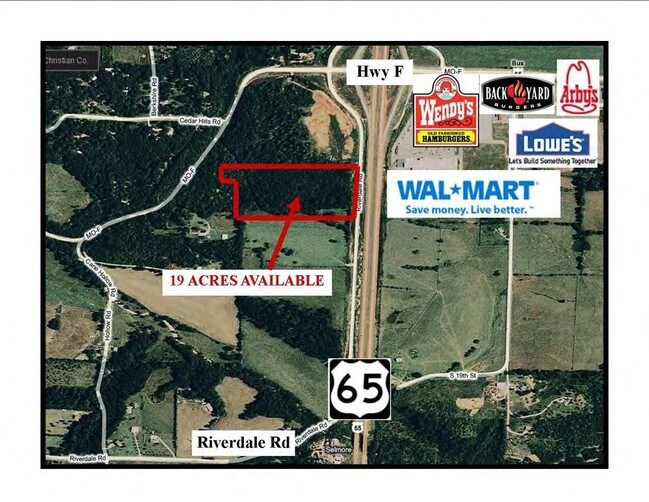
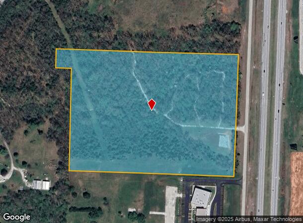
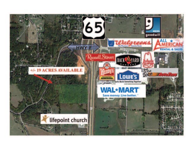
Riverdale Rd, Ozark, MO 65721
NEARBY LISTINGS FOR SALE OR LEASE
Property Detail
Riverdale Rd
Springfield, MO
Ozark Out
11-0.8-33-000-000-021.001
BEG 3970 N & 290 W SEC SE SE TH S765.35 W1056.07 N645.57 W100 N120 E TO POB
Agriculturalland
Christian
X
Missouri
29043C0088D
19 AC
2023
West Christian County
2024
Springfield
020304
DEMOGRAPHICS near Riverdale Rd
1 Mile
3 Mile
5 Mile
2024 Total Population
1,569
17,624
48,110
2029 Population
1,769
19,860
54,402
Pop Growth 2024-2029
+ 12.75%
+ 12.69%
+ 13.08%
Average Age
37
38
38
2024 Total Households
583
6,451
17,873
HH Growth 2024-2029
+ 12.86%
+ 12.79%
+ 13.14%
Median Household Inc
$55,866
$65,107
$70,225
Avg Household Size
2.60
2.60
2.60
2024 Avg HH Vehicles
2.00
2.00
2.00
Median Home Value
$184,673
$193,052
$227,823
Median Year Built
1994
1994
1998
Nearby Places
Map Layers
Map Styles
 Street
 Aerial
- Restaurants
- Banks
- Shops
- Fitness
- Groceries
PUBLIC TRANSPORTATION
AIRPORT
Springfield-Branson Ntl
DRIVE
WALK
Distance
Springfield-Branson Ntl
45 min
30.8 mi
Freight Ports
Tulsa Port of Inola
DRIVE
WALK
Distance
Tulsa Port of Inola
209 min
185.3 mi
SALE & LEASE HISTORY
LISTING DATE
SALE/LEASE

Sep 24, 2016
For Sale
Nearby Properties
Address
Land Use
TOTAL SIZE
Lot Size
Zoning
Address
Land Use
TOTAL SIZE
Lot Size
Zoning
50.60 AC
Address
Land Use
TOTAL SIZE
Lot Size
Zoning
66,038 SF
6.24 AC
Address
Land Use
TOTAL SIZE
Lot Size
Zoning
48,100 SF
10.57 AC
Address
Land Use
TOTAL SIZE
Lot Size
Zoning
114,296 SF
20 AC
Address
Land Use
TOTAL SIZE
Lot Size
Zoning
28.40 AC
Address
Land Use
TOTAL SIZE
Lot Size
Zoning
3.07 AC
Address
Land Use
TOTAL SIZE
Lot Size
Zoning
106,250 SF
8.01 AC
Address
Land Use
TOTAL SIZE
Lot Size
Zoning
38,524 SF
6.54 AC
Address
Land Use
TOTAL SIZE
Lot Size
Zoning
27,268 SF
3.51 AC
Address
Land Use
TOTAL SIZE
Lot Size
Zoning
82,000 SF
4.50 AC
Address
Land Use
TOTAL SIZE
Lot Size
Zoning
67,368 SF
7.98 AC
Address
Land Use
TOTAL SIZE
Lot Size
Zoning
Address
Land Use
TOTAL SIZE
Lot Size
Zoning
24,000 SF
6.46 AC
Address
Land Use
TOTAL SIZE
Lot Size
Zoning
17,626 SF
5.26 AC
Address
Land Use
TOTAL SIZE
Lot Size
Zoning
Address
Land Use
TOTAL SIZE
Lot Size
Zoning
0.54 AC
Address
Land Use
TOTAL SIZE
Lot Size
Zoning
11,520 SF
8.62 AC
Address
Land Use
TOTAL SIZE
Lot Size
Zoning
4,050 SF
4.89 AC
Address
Land Use
TOTAL SIZE
Lot Size
Zoning
75,008 SF
6.12 AC
Address
Land Use
TOTAL SIZE
Lot Size
Zoning
10,928 SF
3.73 AC
Address
Land Use
TOTAL SIZE
Lot Size
Zoning
7,328 SF
2.81 AC
Address
Land Use
TOTAL SIZE
Lot Size
Zoning
11,800 SF
1.53 AC
Address
Land Use
TOTAL SIZE
Lot Size
Zoning
12,620 SF
1.42 AC
Address
Land Use
TOTAL SIZE
Lot Size
Zoning
92,231 SF
4.20 AC
Address
Land Use
TOTAL SIZE
Lot Size
Zoning
4,304 SF
26.17 AC
Address
Land Use
TOTAL SIZE
Lot Size
Zoning
8,650 SF
3.03 AC
Address
Land Use
TOTAL SIZE
Lot Size
Zoning
24,000 SF
2.16 AC
Address
Land Use
TOTAL SIZE
Lot Size
Zoning
47,568 SF
5.70 AC
Address
Land Use
TOTAL SIZE
Lot Size
Zoning
6,000 SF
6.16 AC
Address
Land Use
TOTAL SIZE
Lot Size
Zoning
25,243 SF
16.92 AC
The World's #1 Commercial Real Estate Marketplace
Connect with us
© 2025 CoStar Group
The information above has been obtained from sources believed reliable. While we do not doubt its accuracy we have not verified it and make no guarantee, warranty or representation about it. It is your responsibility to independently confirm its accuracy and completeness. Any projections, opinions, assumptions, or estimates used are for example only and do not represent the current or future performance of the property. The value of this transaction to you depends on tax and other factors which should be evaluated by your tax, financial, and legal advisors. You and your advisors should conduct a careful, independent investigation of the property to determine to your satisfaction the suitability of the property for your needs.