Property Record
Highway 69, Nederland, TX 77627

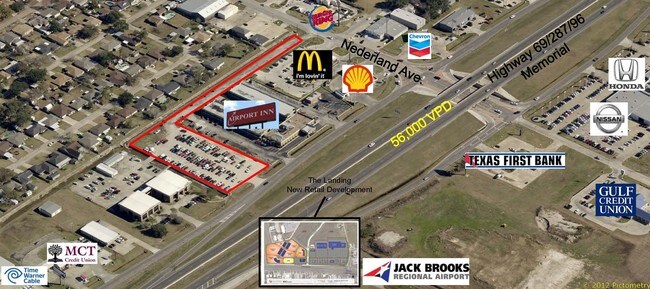
Property Detail
Highway 69
Beaumont/Port Arthur
JEFFERSON
Beaumont-Port Arthur, TX
Texas
300240-000-001900-00000
1.57 AC
Commercialnec
Port Arthur
NEARBY LISTINGS FOR SALE OR LEASE
DEMOGRAPHICS near Highway 69
1 mile
3 mile
5 mile
2025 Total Population
7,437
40,971
68,340
2030 Population
7,390
40,562
67,732
Pop Growth 2025-2030
(0.63%)
(1.00%)
(0.89%)
Average Age
39
39
40
2025 Total Households
2,936
16,736
24,495
HH Growth 2025-2030
(0.72%)
(1.09%)
(1.05%)
Median Household Inc
$85,620
$71,294
$68,520
Avg Household Size
2.50
2.40
2.50
2025 Avg HH Vehicles
2.00
2.00
2.00
Median Home Value
$214,959
$229,172
$206,901
Median Year Built
1969
1978
1975
Nearby Places
Map Layers
Map Styles
 Street
 Aerial
Layers
 Traffic
 Biking
Places
Listings with unknown addresses are not visible on the map
- Restaurants
- Banks
- Shops
- Fitness
- Groceries
SALE & LEASE HISTORY
LISTING DATE
SALE/LEASE

Sep 24, 2016
For Sale
Nearby Properties
Address
Land Use
TOTAL SIZE
Lot Size
Zoning
Address
Land Use
TOTAL SIZE
Lot Size
Zoning
351,556 SF
18.92 AC
Address
Land Use
TOTAL SIZE
Lot Size
Zoning
284,108 SF
25 AC
Address
Land Use
TOTAL SIZE
Lot Size
Zoning
279,375 SF
18.94 AC
Address
Land Use
TOTAL SIZE
Lot Size
Zoning
235,864 SF
12.21 AC
Address
Land Use
TOTAL SIZE
Lot Size
Zoning
221,714 SF
13.91 AC
Address
Land Use
TOTAL SIZE
Lot Size
Zoning
164,371 SF
7.32 AC
Address
Land Use
TOTAL SIZE
Lot Size
Zoning
24,763 SF
2.74 AC
Address
Land Use
TOTAL SIZE
Lot Size
Zoning
67,048 SF
5.40 AC
Address
Land Use
TOTAL SIZE
Lot Size
Zoning
136,295 SF
5.30 AC
Address
Land Use
TOTAL SIZE
Lot Size
Zoning
16,200 SF
2.09 AC
Address
Land Use
TOTAL SIZE
Lot Size
Zoning
56,546 SF
12.50 AC
Address
Land Use
TOTAL SIZE
Lot Size
Zoning
63,836 SF
0.64 AC
Address
Land Use
TOTAL SIZE
Lot Size
Zoning
203,821 SF
19.68 AC
Address
Land Use
TOTAL SIZE
Lot Size
Zoning
129,495 SF
7.23 AC
Address
Land Use
TOTAL SIZE
Lot Size
Zoning
127,946 SF
7.72 AC
Address
Land Use
TOTAL SIZE
Lot Size
Zoning
303,400 SF
14.15 AC
Address
Land Use
TOTAL SIZE
Lot Size
Zoning
17,414 SF
2.20 AC
Address
Land Use
TOTAL SIZE
Lot Size
Zoning
110,499 SF
4.80 AC
Address
Land Use
TOTAL SIZE
Lot Size
Zoning
18,795 SF
2.50 AC
Address
Land Use
TOTAL SIZE
Lot Size
Zoning
628,811 SF
38.48 AC
Address
Land Use
TOTAL SIZE
Lot Size
Zoning
79,096 SF
9.09 AC
Address
Land Use
TOTAL SIZE
Lot Size
Zoning
185,832 SF
10.08 AC
Address
Land Use
TOTAL SIZE
Lot Size
Zoning
55,953 SF
1.87 AC
Address
Land Use
TOTAL SIZE
Lot Size
Zoning
81,675 SF
4.28 AC
Address
Land Use
TOTAL SIZE
Lot Size
Zoning
62,233 SF
6.94 AC
Address
Land Use
TOTAL SIZE
Lot Size
Zoning
121,752 SF
9.88 AC
Address
Land Use
TOTAL SIZE
Lot Size
Zoning
69,960 SF
12.42 AC
Address
Land Use
TOTAL SIZE
Lot Size
Zoning
45,252 SF
13.70 AC
Address
Land Use
TOTAL SIZE
Lot Size
Zoning
101,740 SF
4.30 AC
Address
Land Use
TOTAL SIZE
Lot Size
Zoning
132,007 SF
1.27 AC
The World's #1 Commercial Real Estate Marketplace
Connect with us
© 2026 CoStar Group
The information above has been obtained from sources believed reliable. While we do not doubt its accuracy we have not verified it and make no guarantee, warranty or representation about it. It is your responsibility to independently confirm its accuracy and completeness. Any projections, opinions, assumptions, or estimates used are for example only and do not represent the current or future performance of the property. The value of this transaction to you depends on tax and other factors which should be evaluated by your tax, financial, and legal advisors. You and your advisors should conduct a careful, independent investigation of the property to determine to your satisfaction the suitability of the property for your needs.