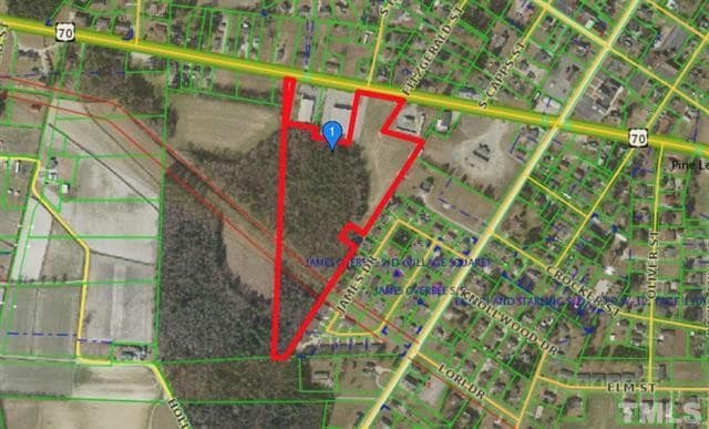
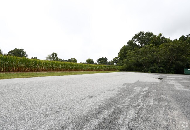
Property Record
Highway 70-A, Selma, NC 27576

Property Detail
Highway 70-A
12005036
TRACT 1 THOMAS 88/120
Publicstorage
JOHNSTON
COM
North Carolina
B and X Area of moderate flood hazard, usually the area between the limits of the 100-year and 500-year floods.
13.40 AC
2025
Johnston County
2025
Raleigh/Durham
040301
Raleigh-Cary, NC
2,800 SF
NEARBY LISTINGS FOR SALE OR LEASE
DEMOGRAPHICS near Highway 70-A
1 mile
3 mile
5 mile
2025 Total Population
2,456
11,677
24,788
2030 Population
2,753
13,041
27,748
Pop Growth 2025-2030
+ 12.09%
+ 11.68%
+ 11.94%
Average Age
39
39
39
2025 Total Households
949
4,519
9,444
HH Growth 2025-2030
+ 12.22%
+ 11.66%
+ 12.01%
Median Household Inc
$70,802
$61,324
$57,890
Avg Household Size
2.60
2.50
2.60
2025 Avg HH Vehicles
2.00
2.00
2.00
Median Home Value
$248,239
$199,558
$199,757
Median Year Built
1995
1985
1988
Nearby Places
Map Layers
Map Styles
 Street
 Aerial
Transit
 Traffic
 Biking
Places
Listings with unknown addresses are not visible on the map
- Restaurants
- Banks
- Shops
- Fitness
- Groceries
PUBLIC TRANSPORTATION
COMMUTER RAIL
Selma (Carolinian - Amtrak, Palmetto - Amtrak)
Drive
Walk
Distance
Selma (Carolinian - Amtrak, Palmetto - Amtrak)
5 min
3.1 mi
Freight Ports
Port of Wilmington
Drive
Walk
Distance
Port of Wilmington
139 min
113.4 mi
SALE & LEASE HISTORY
LISTING DATE
SALE/LEASE

Sep 28, 2018
For Sale
Jan 22, 2018
For Sale
Aug 24, 2018
For Sale
Nearby Properties
Address
Land Use
TOTAL SIZE
Lot Size
Zoning
Address
Land Use
TOTAL SIZE
Lot Size
Zoning
45,000 SF
99.14 AC
IND
Address
Land Use
TOTAL SIZE
Lot Size
Zoning
6,440 SF
16.82 AC
RES
Address
Land Use
TOTAL SIZE
Lot Size
Zoning
134,742 SF
8.20 AC
IND
Address
Land Use
TOTAL SIZE
Lot Size
Zoning
54,009 SF
2.08 AC
COM
Address
Land Use
TOTAL SIZE
Lot Size
Zoning
63,415 SF
5.45 AC
COM
Address
Land Use
TOTAL SIZE
Lot Size
Zoning
112,276 SF
10.57 AC
COM
Address
Land Use
TOTAL SIZE
Lot Size
Zoning
30,370 SF
8.43 AC
COM
Address
Land Use
TOTAL SIZE
Lot Size
Zoning
2,065 SF
24.99 AC
COM
Address
Land Use
TOTAL SIZE
Lot Size
Zoning
57,774 SF
3.79 AC
COM
Address
Land Use
TOTAL SIZE
Lot Size
Zoning
3,600 SF
20.26 AC
RES
Address
Land Use
TOTAL SIZE
Lot Size
Zoning
12,360 SF
7.27 AC
COM
Address
Land Use
TOTAL SIZE
Lot Size
Zoning
1,890 SF
8.08 AC
COM
Address
Land Use
TOTAL SIZE
Lot Size
Zoning
42,888 SF
1.98 AC
COM
Address
Land Use
TOTAL SIZE
Lot Size
Zoning
6,695 SF
8.17 AC
COM
Address
Land Use
TOTAL SIZE
Lot Size
Zoning
41.27 AC
IND
Address
Land Use
TOTAL SIZE
Lot Size
Zoning
5,304 SF
1.29 AC
COM
Address
Land Use
TOTAL SIZE
Lot Size
Zoning
2,496 SF
11.10 AC
RES
Address
Land Use
TOTAL SIZE
Lot Size
Zoning
7,498 SF
3.22 AC
COM
Address
Land Use
TOTAL SIZE
Lot Size
Zoning
99.98 AC
RAG
Address
Land Use
TOTAL SIZE
Lot Size
Zoning
2,624 SF
21.77 AC
COM
Address
Land Use
TOTAL SIZE
Lot Size
Zoning
20,602 SF
4.52 AC
COM
Address
Land Use
TOTAL SIZE
Lot Size
Zoning
40,200 SF
5.22 AC
COM
Address
Land Use
TOTAL SIZE
Lot Size
Zoning
4,964 SF
1.74 AC
COM
Address
Land Use
TOTAL SIZE
Lot Size
Zoning
12,446 SF
2.83 AC
COM
Address
Land Use
TOTAL SIZE
Lot Size
Zoning
3,105 SF
4.62 AC
COM
Address
Land Use
TOTAL SIZE
Lot Size
Zoning
28,598 SF
3.27 AC
COM
Address
Land Use
TOTAL SIZE
Lot Size
Zoning
92,742 SF
20 AC
IND
Address
Land Use
TOTAL SIZE
Lot Size
Zoning
2,712 SF
7.12 AC
RES
Address
Land Use
TOTAL SIZE
Lot Size
Zoning
12.18 AC
COM
The World's #1 Commercial Real Estate Marketplace
Connect with us
© 2026 CoStar Group
The information above has been obtained from sources believed reliable. While we do not doubt its accuracy we have not verified it and make no guarantee, warranty or representation about it. It is your responsibility to independently confirm its accuracy and completeness. Any projections, opinions, assumptions, or estimates used are for example only and do not represent the current or future performance of the property. The value of this transaction to you depends on tax and other factors which should be evaluated by your tax, financial, and legal advisors. You and your advisors should conduct a careful, independent investigation of the property to determine to your satisfaction the suitability of the property for your needs.