Property Record
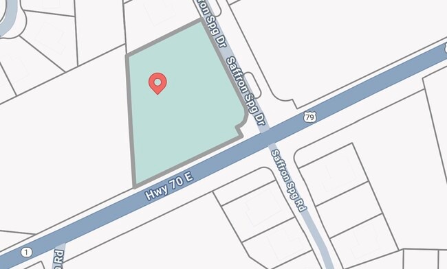
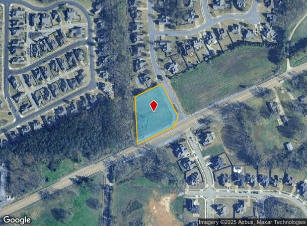
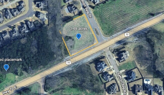
Highway 70, Arlington, TN 38002
This Property Is For Sale
NEARBY LISTINGS FOR SALE OR LEASE
Property Detail
Highway 70
L0-141-0-0359
NS HIGHWAY 70 SEE MAP D1-41- (GRID #076E)
Vacantlandnec
Shelby
X
Tennessee
47157C0215G
1.48 AC
2022
North
2025
Memphis
020836
Memphis, TN-MS-AR
DEMOGRAPHICS near Highway 70
1 Mile
3 Mile
5 Mile
2024 Total Population
1,991
12,306
40,097
2029 Population
1,963
12,002
39,153
Pop Growth 2024-2029
(1.41%)
(2.47%)
(2.35%)
Average Age
38
37
37
2024 Total Households
632
3,889
13,673
HH Growth 2024-2029
(1.58%)
(2.67%)
(2.55%)
Median Household Inc
$132,031
$119,216
$105,706
Avg Household Size
3.10
3.10
2.90
2024 Avg HH Vehicles
2.00
2.00
2.00
Median Home Value
$420,000
$352,828
$330,493
Median Year Built
2006
2003
2001
Nearby Places
- Restaurants
- Banks
- Shops
- Fitness
- Groceries
PUBLIC TRANSPORTATION
AIRPORT
Memphis International
DRIVE
WALK
Distance
Memphis International
40 min
27.7 mi
Freight Ports
Port of Shreveport
DRIVE
WALK
Distance
Port of Shreveport
431 min
391.9 mi
Nearby Properties
Address
Land Use
TOTAL SIZE
Lot Size
Zoning
Address
Land Use
TOTAL SIZE
Lot Size
Zoning
129,662 SF
10.25 AC
CA
Address
Land Use
TOTAL SIZE
Lot Size
Zoning
68,940 SF
8.78 AC
CA
Address
Land Use
TOTAL SIZE
Lot Size
Zoning
93,928 SF
3.85 AC
M-1
Address
Land Use
TOTAL SIZE
Lot Size
Zoning
44,125 SF
5.26 AC
M-1
Address
Land Use
TOTAL SIZE
Lot Size
Zoning
51,237 SF
12.46 AC
RS-13
Address
Land Use
TOTAL SIZE
Lot Size
Zoning
105,178 SF
15.78 AC
M-1
Address
Land Use
TOTAL SIZE
Lot Size
Zoning
38,926 SF
2.90 AC
S-C
Address
Land Use
TOTAL SIZE
Lot Size
Zoning
53,670 SF
6.69 AC
M-1
Address
Land Use
TOTAL SIZE
Lot Size
Zoning
35,909 SF
1.07 AC
M-1
Address
Land Use
TOTAL SIZE
Lot Size
Zoning
29,762 SF
2.63 AC
S-C
Address
Land Use
TOTAL SIZE
Lot Size
Zoning
159,960 SF
54.99 AC
M-1
Address
Land Use
TOTAL SIZE
Lot Size
Zoning
58,203 SF
3.49 AC
O
Address
Land Use
TOTAL SIZE
Lot Size
Zoning
50,600 SF
1.91 AC
M-1
Address
Land Use
TOTAL SIZE
Lot Size
Zoning
296,005 SF
23.11 AC
M-1
Address
Land Use
TOTAL SIZE
Lot Size
Zoning
26,125 SF
6.20 AC
M-1
Address
Land Use
TOTAL SIZE
Lot Size
Zoning
95,550 SF
6.14 AC
M-1
Address
Land Use
TOTAL SIZE
Lot Size
Zoning
47,140 SF
4.36 AC
M-1
Address
Land Use
TOTAL SIZE
Lot Size
Zoning
85,875 SF
4.96 AC
S-C
Address
Land Use
TOTAL SIZE
Lot Size
Zoning
170 AC
RS-6
Address
Land Use
TOTAL SIZE
Lot Size
Zoning
61,344 SF
10.58 AC
O
Address
Land Use
TOTAL SIZE
Lot Size
Zoning
324.75 AC
RS-6
Address
Land Use
TOTAL SIZE
Lot Size
Zoning
19,031 SF
3 AC
E
Address
Land Use
TOTAL SIZE
Lot Size
Zoning
51,738 SF
6.05 AC
B-E
Address
Land Use
TOTAL SIZE
Lot Size
Zoning
5.87 AC
M-1
Address
Land Use
TOTAL SIZE
Lot Size
Zoning
100.29 AC
AG
Address
Land Use
TOTAL SIZE
Lot Size
Zoning
19,800 SF
2.14 AC
S-C
Address
Land Use
TOTAL SIZE
Lot Size
Zoning
23,952 SF
3.61 AC
S-C
Address
Land Use
TOTAL SIZE
Lot Size
Zoning
13,966 SF
1.32 AC
S-C
Address
Land Use
TOTAL SIZE
Lot Size
Zoning
4,536 SF
2.12 AC
E
Address
Land Use
TOTAL SIZE
Lot Size
Zoning
8,359 SF
1.67 AC
CA
The World's #1 Commercial Real Estate Marketplace
Connect with us
© 2025 CoStar Group
The information above has been obtained from sources believed reliable. While we do not doubt its accuracy we have not verified it and make no guarantee, warranty or representation about it. It is your responsibility to independently confirm its accuracy and completeness. Any projections, opinions, assumptions, or estimates used are for example only and do not represent the current or future performance of the property. The value of this transaction to you depends on tax and other factors which should be evaluated by your tax, financial, and legal advisors. You and your advisors should conduct a careful, independent investigation of the property to determine to your satisfaction the suitability of the property for your needs.