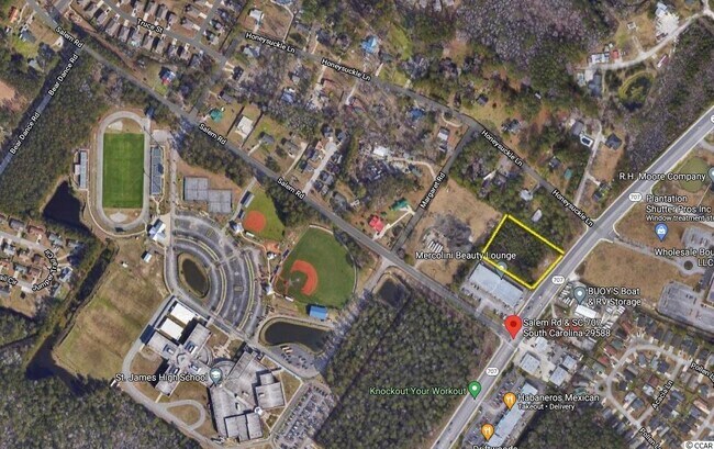
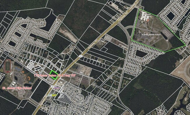
Property Record
Highway 707, Myrtle Beach, SC 29588

NEARBY LISTINGS FOR SALE OR LEASE
Property Detail
Highway 707
Myrtle Beach-Conway-North Myrtle Beach, SC-NC
Hwy 544 Ranchettes
45716040024
HWY 544 RANCHETTES; LT 2
Commercialnec
Horry
X
South Carolina
45043C0250G
2
0
1.95 AC
2024
Outlying Horry County
051606
Myrtle Beach/Conway
DEMOGRAPHICS near Highway 707
1 Mile
3 Mile
5 Mile
2024 Total Population
2,698
37,034
77,927
2029 Population
3,245
44,727
93,785
Pop Growth 2024-2029
+ 20.27%
+ 20.77%
+ 20.35%
Average Age
46
51
50
2024 Total Households
1,116
16,822
35,605
HH Growth 2024-2029
+ 19.09%
+ 19.56%
+ 19.27%
Median Household Inc
$62,554
$58,489
$60,418
Avg Household Size
2.30
2.10
2.10
2024 Avg HH Vehicles
2.00
2.00
2.00
Median Home Value
$260,353
$230,533
$245,010
Median Year Built
2004
2002
1997
Nearby Places
Map Layers
Map Styles
 Street
 Aerial
- Restaurants
- Banks
- Shops
- Fitness
- Groceries
PUBLIC TRANSPORTATION
AIRPORT
Myrtle Beach International
DRIVE
WALK
Distance
Myrtle Beach International
24 min
13.3 mi
Freight Ports
Wando Welch Terminal
DRIVE
WALK
Distance
Wando Welch Terminal
109 min
80.9 mi
SALE & LEASE HISTORY
LISTING DATE
SALE/LEASE

Sep 16, 2022
For Sale
Jun 30, 2021
For Sale
Nearby Properties
Address
Land Use
TOTAL SIZE
Lot Size
Zoning
Address
Land Use
TOTAL SIZE
Lot Size
Zoning
7,144 SF
187.64 AC
Address
Land Use
TOTAL SIZE
Lot Size
Zoning
151,727 SF
21.25 AC
Address
Land Use
TOTAL SIZE
Lot Size
Zoning
636.82 AC
Address
Land Use
TOTAL SIZE
Lot Size
Zoning
Address
Land Use
TOTAL SIZE
Lot Size
Zoning
4,800 SF
75.54 AC
Address
Land Use
TOTAL SIZE
Lot Size
Zoning
65,578 SF
12.12 AC
Address
Land Use
TOTAL SIZE
Lot Size
Zoning
28,278 SF
50.53 AC
Address
Land Use
TOTAL SIZE
Lot Size
Zoning
64,620 SF
7.90 AC
Address
Land Use
TOTAL SIZE
Lot Size
Zoning
8,012 SF
7.40 AC
Address
Land Use
TOTAL SIZE
Lot Size
Zoning
3,450 SF
5.28 AC
RMM1*
Address
Land Use
TOTAL SIZE
Lot Size
Zoning
49.53 AC
Address
Land Use
TOTAL SIZE
Lot Size
Zoning
Address
Land Use
TOTAL SIZE
Lot Size
Zoning
108,250 SF
14.53 AC
Address
Land Use
TOTAL SIZE
Lot Size
Zoning
8,640 SF
5.47 AC
Address
Land Use
TOTAL SIZE
Lot Size
Zoning
80,797 SF
33.77 AC
Address
Land Use
TOTAL SIZE
Lot Size
Zoning
69,048 SF
12.59 AC
Address
Land Use
TOTAL SIZE
Lot Size
Zoning
93,048 SF
2.24 AC
Address
Land Use
TOTAL SIZE
Lot Size
Zoning
38,829 SF
6.52 AC
Address
Land Use
TOTAL SIZE
Lot Size
Zoning
22,536 SF
3 AC
Address
Land Use
TOTAL SIZE
Lot Size
Zoning
35,945 SF
5.37 AC
Address
Land Use
TOTAL SIZE
Lot Size
Zoning
73,260 SF
2.73 AC
Address
Land Use
TOTAL SIZE
Lot Size
Zoning
8,340 SF
5.26 AC
Address
Land Use
TOTAL SIZE
Lot Size
Zoning
148 SF
77.18 AC
Address
Land Use
TOTAL SIZE
Lot Size
Zoning
16,128 SF
9.65 AC
Address
Land Use
TOTAL SIZE
Lot Size
Zoning
33,000 SF
7.36 AC
Address
Land Use
TOTAL SIZE
Lot Size
Zoning
59.91 AC
Address
Land Use
TOTAL SIZE
Lot Size
Zoning
4,576 SF
40.70 AC
Address
Land Use
TOTAL SIZE
Lot Size
Zoning
44,242 SF
6.27 AC
The World's #1 Commercial Real Estate Marketplace
Connect with us
© 2026 CoStar Group
The information above has been obtained from sources believed reliable. While we do not doubt its accuracy we have not verified it and make no guarantee, warranty or representation about it. It is your responsibility to independently confirm its accuracy and completeness. Any projections, opinions, assumptions, or estimates used are for example only and do not represent the current or future performance of the property. The value of this transaction to you depends on tax and other factors which should be evaluated by your tax, financial, and legal advisors. You and your advisors should conduct a careful, independent investigation of the property to determine to your satisfaction the suitability of the property for your needs.