Property Record
Us Highway 74 Byp, Laurinburg, NC 28352

Current Lease Availabilities
Land LEASE
Negotiable
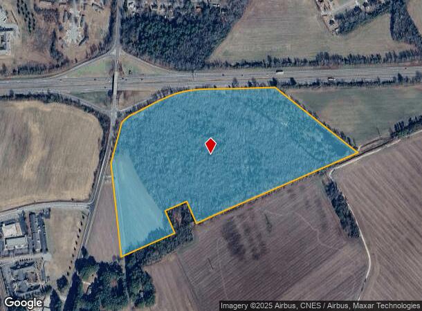
48.81 AC Lot
NEARBY LISTINGS FOR SALE OR LEASE
Property Detail
Us Highway 74 Byp
Laurinburg, NC
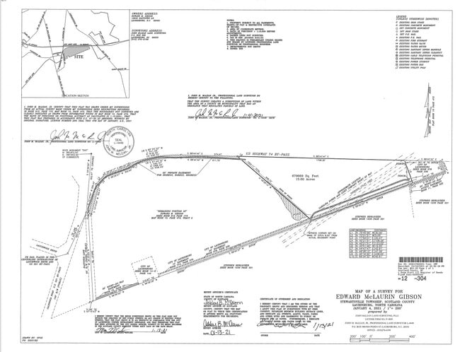
Map Of Survey For Edwra Dmclaurin Gibson
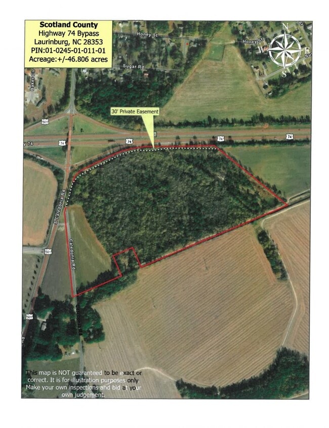
01-0245-01-011.01
TRT 2 H F MONROE
Vacantlandnec
Scotland
X
North Carolina
3710836600K
48.81 AC
2025
North Carolina Southeast Area
2025
Other Market Areas
010102
DEMOGRAPHICS near Us Highway 74 Byp
1 Mile
3 Mile
5 Mile
2024 Total Population
2,007
14,449
20,540
2029 Population
2,024
14,575
20,627
Pop Growth 2024-2029
+ 0.85%
+ 0.87%
+ 0.42%
Average Age
40
41
41
2024 Total Households
773
5,600
7,706
HH Growth 2024-2029
+ 0.78%
+ 0.91%
+ 0.40%
Median Household Inc
$25,441
$37,523
$41,392
Avg Household Size
2.40
2.30
2.30
2024 Avg HH Vehicles
1.00
2.00
2.00
Median Home Value
$76,023
$119,935
$131,424
Median Year Built
1972
1973
1975
Nearby Places
- Restaurants
- Banks
- Shops
- Fitness
- Groceries
PUBLIC TRANSPORTATION
AIRPORT
Fayetteville Regional/Grannis Field
DRIVE
WALK
Distance
Fayetteville Regional/Grannis Field
59 min
41.7 mi
Nearby Properties
Address
Land Use
TOTAL SIZE
Lot Size
Zoning
Address
Land Use
TOTAL SIZE
Lot Size
Zoning
61,000 SF
43.43 AC
OI
Address
Land Use
TOTAL SIZE
Lot Size
Zoning
49,402 SF
83.30 AC
OI
Address
Land Use
TOTAL SIZE
Lot Size
Zoning
53,392 SF
207 AC
OI
Address
Land Use
TOTAL SIZE
Lot Size
Zoning
114,260 SF
29.90 AC
OI
Address
Land Use
TOTAL SIZE
Lot Size
Zoning
101,856 SF
25 AC
OI
Address
Land Use
TOTAL SIZE
Lot Size
Zoning
62,578 SF
2.41 AC
OI
Address
Land Use
TOTAL SIZE
Lot Size
Zoning
190,890 SF
10.33 AC
GB
Address
Land Use
TOTAL SIZE
Lot Size
Zoning
13,148 SF
8.45 AC
R6
Address
Land Use
TOTAL SIZE
Lot Size
Zoning
53,774 SF
9.58 AC
OI
Address
Land Use
TOTAL SIZE
Lot Size
Zoning
39,654 SF
0.64 AC
CB
Address
Land Use
TOTAL SIZE
Lot Size
Zoning
92,385 SF
13.77 AC
GB
Address
Land Use
TOTAL SIZE
Lot Size
Zoning
39,894 SF
68.32 AC
I
Address
Land Use
TOTAL SIZE
Lot Size
Zoning
56,844 SF
6.24 AC
GB
Address
Land Use
TOTAL SIZE
Lot Size
Zoning
11,088 SF
10.60 AC
R6
Address
Land Use
TOTAL SIZE
Lot Size
Zoning
55,316 SF
1.01 AC
OI
Address
Land Use
TOTAL SIZE
Lot Size
Zoning
33,046 SF
3.75 AC
OI
Address
Land Use
TOTAL SIZE
Lot Size
Zoning
86,156 SF
9.50 AC
GB
Address
Land Use
TOTAL SIZE
Lot Size
Zoning
36,820 SF
1.71 AC
GB
Address
Land Use
TOTAL SIZE
Lot Size
Zoning
14,752 SF
4.31 AC
OI
Address
Land Use
TOTAL SIZE
Lot Size
Zoning
11,824 SF
59.60 AC
I
Address
Land Use
TOTAL SIZE
Lot Size
Zoning
33,708 SF
7.26 AC
GB
Address
Land Use
TOTAL SIZE
Lot Size
Zoning
1,465 SF
10 AC
R6
Address
Land Use
TOTAL SIZE
Lot Size
Zoning
4,900 SF
14.05 AC
OI
Address
Land Use
TOTAL SIZE
Lot Size
Zoning
37,592 SF
14.99 AC
OI
Address
Land Use
TOTAL SIZE
Lot Size
Zoning
34,184 SF
7.70 AC
GB
Address
Land Use
TOTAL SIZE
Lot Size
Zoning
26,502 SF
5.83 AC
OI
Address
Land Use
TOTAL SIZE
Lot Size
Zoning
17,960 SF
9.81 AC
OI
Address
Land Use
TOTAL SIZE
Lot Size
Zoning
37,345 SF
0.78 AC
OI
Address
Land Use
TOTAL SIZE
Lot Size
Zoning
6,360 SF
10 AC
R20
The World's #1 Commercial Real Estate Marketplace
Connect with us
© 2025 CoStar Group
The information above has been obtained from sources believed reliable. While we do not doubt its accuracy we have not verified it and make no guarantee, warranty or representation about it. It is your responsibility to independently confirm its accuracy and completeness. Any projections, opinions, assumptions, or estimates used are for example only and do not represent the current or future performance of the property. The value of this transaction to you depends on tax and other factors which should be evaluated by your tax, financial, and legal advisors. You and your advisors should conduct a careful, independent investigation of the property to determine to your satisfaction the suitability of the property for your needs.