Property Record
Highway 76 E, White House, TN 37188


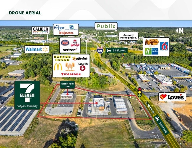
Property Detail
Highway 76 E
074106F A 01302
ROBERTSON
Residentialacreage
Tennessee
B and X Area of moderate flood hazard, usually the area between the limits of the 100-year and 500-year floods.
8.20 AC
0
Robertson County
2025
Nashville
080103
Nashville-Davidson--Murfreesboro--Franklin, TN
NEARBY LISTINGS FOR SALE OR LEASE
-
-
SE Corner of Raymond Hirsch Pkwy & TN Hwy 76
White House, TN 37188
Negotiable
1,000 - 1,400 SF
Retail
-
View all White House listings for sale on LoopNet.com
DEMOGRAPHICS near Highway 76 E
1 mile
3 mile
5 mile
2025 Total Population
1,584
17,972
30,301
2030 Population
1,728
19,539
32,650
Pop Growth 2025-2030
+ 9.09%
+ 8.72%
+ 7.75%
Average Age
39
39
40
2025 Total Households
619
6,789
11,308
HH Growth 2025-2030
+ 9.21%
+ 8.94%
+ 7.97%
Median Household Inc
$84,047
$87,004
$90,459
Avg Household Size
2.50
2.60
2.70
2025 Avg HH Vehicles
2.00
2.00
2.00
Median Home Value
$308,503
$339,016
$362,265
Median Year Built
2004
2001
1997
Nearby Places
Map Layers
Map Styles
 Street
 Aerial
Layers
 Traffic
 Biking
Places
Listings with unknown addresses are not visible on the map
- Restaurants
- Banks
- Shops
- Fitness
- Groceries
PUBLIC TRANSPORTATION
AIRPORT
Nashville International
Drive
Walk
Distance
Nashville International
41 min
32.9 mi
Freight Ports
Port of Toledo
Drive
Walk
Distance
Port of Toledo
516 min
453.0 mi
SALE & LEASE HISTORY
LISTING DATE
SALE/LEASE

Sep 20, 2024
For Sale
Oct 07, 2025
For Sale
Nearby Properties
Address
Land Use
TOTAL SIZE
Lot Size
Zoning
Address
Land Use
TOTAL SIZE
Lot Size
Zoning
11,112 SF
22.38 AC
Address
Land Use
TOTAL SIZE
Lot Size
Zoning
31,104 SF
15.46 AC
Address
Land Use
TOTAL SIZE
Lot Size
Zoning
87,440 SF
12.14 AC
Address
Land Use
TOTAL SIZE
Lot Size
Zoning
109,799 SF
13.10 AC
Address
Land Use
TOTAL SIZE
Lot Size
Zoning
92,610 SF
33.42 AC
Address
Land Use
TOTAL SIZE
Lot Size
Zoning
71,143 SF
9.94 AC
Address
Land Use
TOTAL SIZE
Lot Size
Zoning
21,525 SF
12.02 AC
Address
Land Use
TOTAL SIZE
Lot Size
Zoning
324,215 SF
20.70 AC
Address
Land Use
TOTAL SIZE
Lot Size
Zoning
78,384 SF
11.05 AC
Address
Land Use
TOTAL SIZE
Lot Size
Zoning
201,470 SF
23.93 AC
Address
Land Use
TOTAL SIZE
Lot Size
Zoning
183,825 SF
18.40 AC
Address
Land Use
TOTAL SIZE
Lot Size
Zoning
24,744 SF
7 AC
Address
Land Use
TOTAL SIZE
Lot Size
Zoning
36,243 SF
22.90 AC
Address
Land Use
TOTAL SIZE
Lot Size
Zoning
272,640 SF
37.67 AC
Address
Land Use
TOTAL SIZE
Lot Size
Zoning
48,459 SF
5.16 AC
Address
Land Use
TOTAL SIZE
Lot Size
Zoning
23,150 SF
2.32 AC
Address
Land Use
TOTAL SIZE
Lot Size
Zoning
59,170 SF
6.58 AC
Address
Land Use
TOTAL SIZE
Lot Size
Zoning
101,840 SF
11.52 AC
Address
Land Use
TOTAL SIZE
Lot Size
Zoning
9,324 SF
3.03 AC
Address
Land Use
TOTAL SIZE
Lot Size
Zoning
32,512 SF
5.07 AC
Address
Land Use
TOTAL SIZE
Lot Size
Zoning
13,395 SF
21.40 AC
Address
Land Use
TOTAL SIZE
Lot Size
Zoning
7,632 SF
3.60 AC
Address
Land Use
TOTAL SIZE
Lot Size
Zoning
52,770 SF
5.32 AC
C2
Address
Land Use
TOTAL SIZE
Lot Size
Zoning
8,798 SF
3.08 AC
Address
Land Use
TOTAL SIZE
Lot Size
Zoning
47,912 SF
2.28 AC
Address
Land Use
TOTAL SIZE
Lot Size
Zoning
39,440 SF
1.93 AC
Address
Land Use
TOTAL SIZE
Lot Size
Zoning
36,398 SF
1.72 AC
Address
Land Use
TOTAL SIZE
Lot Size
Zoning
36,238 SF
3.69 AC
Address
Land Use
TOTAL SIZE
Lot Size
Zoning
28,864 SF
16.36 AC
Address
Land Use
TOTAL SIZE
Lot Size
Zoning
42,350 SF
3.05 AC
The World's #1 Commercial Real Estate Marketplace
Connect with us
© 2026 CoStar Group
The information above has been obtained from sources believed reliable. While we do not doubt its accuracy we have not verified it and make no guarantee, warranty or representation about it. It is your responsibility to independently confirm its accuracy and completeness. Any projections, opinions, assumptions, or estimates used are for example only and do not represent the current or future performance of the property. The value of this transaction to you depends on tax and other factors which should be evaluated by your tax, financial, and legal advisors. You and your advisors should conduct a careful, independent investigation of the property to determine to your satisfaction the suitability of the property for your needs.