Property Record
Highway 78, Julian, CA 92036
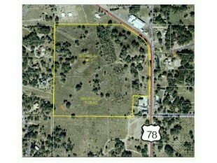

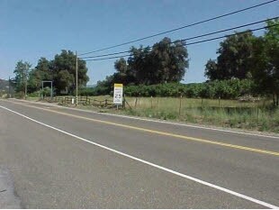

Property Detail
Highway 78
248-060-38
SEC 26-12-3E SWQ PAR B PER DOC16-0014592 IN SWQ OF
Multifamilydwelling
SAN DIEGO
A70
California
D Areas with possible but undetermined flood hazards.
24.81 AC
2024
Outlying SD County N
2025
San Diego
021001
San Diego-Chula Vista-Carlsbad, CA
NEARBY LISTINGS FOR SALE OR LEASE
DEMOGRAPHICS near Highway 78
1 mile
3 mile
5 mile
2025 Total Population
417
694
1,996
2030 Population
382
634
1,822
Pop Growth 2025-2030
(8.39%)
(8.65%)
(8.72%)
Average Age
51
50
48
2025 Total Households
185
308
851
HH Growth 2025-2030
(8.65%)
(9.09%)
(8.93%)
Median Household Inc
$153,879
$103,804
$88,527
Avg Household Size
2.30
2.20
2.20
2025 Avg HH Vehicles
2.00
2.00
2.00
Median Home Value
$888,392
$850,446
$755,434
Median Year Built
1979
1978
1977
Nearby Places
Map Layers
Map Styles
 Street
 Aerial
Layers
 Traffic
 Biking
Places
Listings with unknown addresses are not visible on the map
- Restaurants
- Banks
- Shops
- Fitness
- Groceries
Nearby Properties
Address
Land Use
TOTAL SIZE
Lot Size
Zoning
Address
Land Use
TOTAL SIZE
Lot Size
Zoning
11,810 SF
2.79 AC
RC
Address
Land Use
TOTAL SIZE
Lot Size
Zoning
5,464 SF
336.53 AC
A72
Address
Land Use
TOTAL SIZE
Lot Size
Zoning
46.32 AC
A70
Address
Land Use
TOTAL SIZE
Lot Size
Zoning
7,256 SF
5.54 AC
C36
Address
Land Use
TOTAL SIZE
Lot Size
Zoning
11,950 SF
4.63 AC
C36
Address
Land Use
TOTAL SIZE
Lot Size
Zoning
3,808 SF
62.31 AC
A70
Address
Land Use
TOTAL SIZE
Lot Size
Zoning
5,677 SF
38.16 AC
A72
Address
Land Use
TOTAL SIZE
Lot Size
Zoning
39.66 AC
A72
Address
Land Use
TOTAL SIZE
Lot Size
Zoning
4,166 SF
2.02 AC
C34
Address
Land Use
TOTAL SIZE
Lot Size
Zoning
5,150 SF
36.57 AC
A72
Address
Land Use
TOTAL SIZE
Lot Size
Zoning
40.24 AC
A72
Address
Land Use
TOTAL SIZE
Lot Size
Zoning
19,220 SF
8.23 AC
M54
Address
Land Use
TOTAL SIZE
Lot Size
Zoning
2,100 SF
33.95 AC
A72
Address
Land Use
TOTAL SIZE
Lot Size
Zoning
1.84 AC
C36
Address
Land Use
TOTAL SIZE
Lot Size
Zoning
5,279 SF
10.49 AC
A70
Address
Land Use
TOTAL SIZE
Lot Size
Zoning
3,303 SF
0.69 AC
C40
Address
Land Use
TOTAL SIZE
Lot Size
Zoning
7.43 AC
RMH7
Address
Land Use
TOTAL SIZE
Lot Size
Zoning
1,715 SF
32.27 AC
A70
Address
Land Use
TOTAL SIZE
Lot Size
Zoning
3,662 SF
0.11 AC
C34
Address
Land Use
TOTAL SIZE
Lot Size
Zoning
39.04 AC
A72
Address
Land Use
TOTAL SIZE
Lot Size
Zoning
3,738 SF
0.28 AC
C34
Address
Land Use
TOTAL SIZE
Lot Size
Zoning
3,820 SF
0.85 AC
C34
Address
Land Use
TOTAL SIZE
Lot Size
Zoning
11,026 SF
1.74 AC
C40
Address
Land Use
TOTAL SIZE
Lot Size
Zoning
4,997 SF
5 AC
A70
Address
Land Use
TOTAL SIZE
Lot Size
Zoning
1,224 SF
0.63 AC
C34
Address
Land Use
TOTAL SIZE
Lot Size
Zoning
2,970 SF
25.72 AC
A70
Address
Land Use
TOTAL SIZE
Lot Size
Zoning
4,084 SF
0.24 AC
C34
Address
Land Use
TOTAL SIZE
Lot Size
Zoning
19.57 AC
A72
Address
Land Use
TOTAL SIZE
Lot Size
Zoning
5,508 SF
0.12 AC
C34
The World's #1 Commercial Real Estate Marketplace
Connect with us
© 2026 CoStar Group
The information above has been obtained from sources believed reliable. While we do not doubt its accuracy we have not verified it and make no guarantee, warranty or representation about it. It is your responsibility to independently confirm its accuracy and completeness. Any projections, opinions, assumptions, or estimates used are for example only and do not represent the current or future performance of the property. The value of this transaction to you depends on tax and other factors which should be evaluated by your tax, financial, and legal advisors. You and your advisors should conduct a careful, independent investigation of the property to determine to your satisfaction the suitability of the property for your needs.