Property Record
Highway 78, Ladson, SC 29456
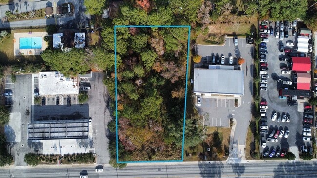


Property Detail
Highway 78
Charleston-North Charleston, SC
SUBDIVISION NAME -BLUE HOUSE RD DESCRIPTION -PARCEL A SITE NAME -N SIDE
487-00-00-032
CHARLESTON
Commercialacreage
South Carolina
B and X Area of moderate flood hazard, usually the area between the limits of the 100-year and 500-year floods.
0.95 AC
2025
North Charleston
2024
Charleston/N Charleston
010814
NEARBY LISTINGS FOR SALE OR LEASE
DEMOGRAPHICS near Highway 78
1 mile
3 mile
5 mile
2025 Total Population
3,539
54,817
193,631
2030 Population
3,803
59,253
210,615
Pop Growth 2025-2030
+ 7.46%
+ 8.09%
+ 8.77%
Average Age
36
38
38
2025 Total Households
1,552
21,085
74,473
HH Growth 2025-2030
+ 7.35%
+ 8.20%
+ 8.99%
Median Household Inc
$89,333
$86,223
$76,463
Avg Household Size
2.30
2.50
2.50
2025 Avg HH Vehicles
2.00
2.00
2.00
Median Home Value
$270,764
$303,514
$293,304
Median Year Built
2010
2000
1998
Nearby Places
Map Layers
Map Styles
 Street
 Aerial
Layers
 Traffic
 Biking
Places
Listings with unknown addresses are not visible on the map
- Restaurants
- Banks
- Shops
- Fitness
- Groceries
PUBLIC TRANSPORTATION
AIRPORT
Charleston AFB/International
Drive
Walk
Distance
Charleston AFB/International
19 min
10.5 mi
Freight Ports
North Charleston Terminal
Drive
Walk
Distance
North Charleston Terminal
15 min
9.7 mi
SALE & LEASE HISTORY
LISTING DATE
SALE/LEASE

Sep 24, 2016
For Sale
Oct 16, 2018
For Lease
Oct 16, 2018
For Sale
Nov 16, 2020
For Sale
Jan 31, 2022
For Sale
Dec 11, 2024
For Sale
Nearby Properties
Address
Land Use
TOTAL SIZE
Lot Size
Zoning
Address
Land Use
TOTAL SIZE
Lot Size
Zoning
Address
Land Use
TOTAL SIZE
Lot Size
Zoning
1,520 SF
12 AC
BERKELEY C
Address
Land Use
TOTAL SIZE
Lot Size
Zoning
48.89 AC
Address
Land Use
TOTAL SIZE
Lot Size
Zoning
511,092 SF
53.35 AC
GOOSE CREE
Address
Land Use
TOTAL SIZE
Lot Size
Zoning
2,551 SF
12.96 AC
BERKELEY C
Address
Land Use
TOTAL SIZE
Lot Size
Zoning
1,430 SF
28.27 AC
Address
Land Use
TOTAL SIZE
Lot Size
Zoning
182,112 SF
38.64 AC
Address
Land Use
TOTAL SIZE
Lot Size
Zoning
152,460 SF
26.94 AC
Address
Land Use
TOTAL SIZE
Lot Size
Zoning
28,770 SF
15.53 AC
Address
Land Use
TOTAL SIZE
Lot Size
Zoning
14.75 AC
Address
Land Use
TOTAL SIZE
Lot Size
Zoning
16.40 AC
Address
Land Use
TOTAL SIZE
Lot Size
Zoning
16.53 AC
Address
Land Use
TOTAL SIZE
Lot Size
Zoning
1,272 SF
18.46 AC
Address
Land Use
TOTAL SIZE
Lot Size
Zoning
Address
Land Use
TOTAL SIZE
Lot Size
Zoning
33.62 AC
Address
Land Use
TOTAL SIZE
Lot Size
Zoning
14.33 AC
Address
Land Use
TOTAL SIZE
Lot Size
Zoning
181,427 SF
16.47 AC
Address
Land Use
TOTAL SIZE
Lot Size
Zoning
21,710 SF
4.30 AC
GOOSE CREE
Address
Land Use
TOTAL SIZE
Lot Size
Zoning
167,144 SF
23.79 AC
GOOSE CREE
Address
Land Use
TOTAL SIZE
Lot Size
Zoning
17,400 SF
15.12 AC
BERKELEY C
Address
Land Use
TOTAL SIZE
Lot Size
Zoning
30,716 SF
4.90 AC
GOOSE CREE
Address
Land Use
TOTAL SIZE
Lot Size
Zoning
194,515 SF
26.73 AC
Address
Land Use
TOTAL SIZE
Lot Size
Zoning
30,790 SF
7.59 AC
BERKELEY C
Address
Land Use
TOTAL SIZE
Lot Size
Zoning
Address
Land Use
TOTAL SIZE
Lot Size
Zoning
22,910 SF
15.70 AC
BERKELEY C
Address
Land Use
TOTAL SIZE
Lot Size
Zoning
124,678 SF
65.93 AC
Address
Land Use
TOTAL SIZE
Lot Size
Zoning
14,725 SF
3.55 AC
Address
Land Use
TOTAL SIZE
Lot Size
Zoning
13,620 SF
9.44 AC
BERKELEY C
Address
Land Use
TOTAL SIZE
Lot Size
Zoning
Address
Land Use
TOTAL SIZE
Lot Size
Zoning
11,036 SF
9.19 AC
BERKELEY C
The World's #1 Commercial Real Estate Marketplace
Connect with us
© 2026 CoStar Group
The information above has been obtained from sources believed reliable. While we do not doubt its accuracy we have not verified it and make no guarantee, warranty or representation about it. It is your responsibility to independently confirm its accuracy and completeness. Any projections, opinions, assumptions, or estimates used are for example only and do not represent the current or future performance of the property. The value of this transaction to you depends on tax and other factors which should be evaluated by your tax, financial, and legal advisors. You and your advisors should conduct a careful, independent investigation of the property to determine to your satisfaction the suitability of the property for your needs.