Property Record
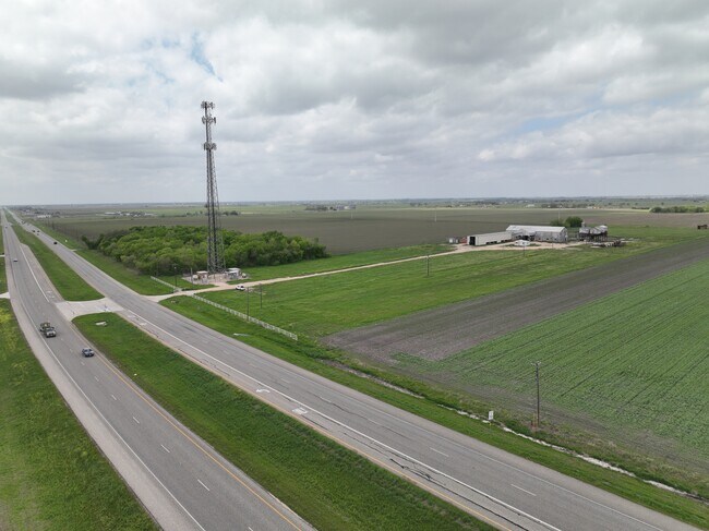
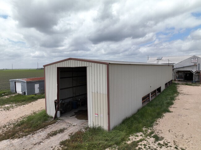
24301 Highway 79, Thrall, TX 76578

Property Detail
24301 Highway 79
R562935
AW0059 AW0059 - BEVIL, J. SUR., ACRES 15.27
Industrialgeneral
WILLIAMSON
B and X Area of moderate flood hazard, usually the area between the limits of the 100-year and 500-year floods.
Texas
2024
15.27 AC
2025
Georgetown
020900
Austin
9,272 SF
Austin-Round Rock-San Marcos, TX
NEARBY LISTINGS FOR SALE OR LEASE
DEMOGRAPHICS near 24301 Highway 79
1 mile
3 mile
5 mile
2025 Total Population
808
1,546
2,927
2030 Population
908
1,739
3,310
Pop Growth 2025-2030
+ 12.38%
+ 12.48%
+ 13.09%
Average Age
39
41
42
2025 Total Households
299
577
1,100
HH Growth 2025-2030
+ 12.71%
+ 12.82%
+ 13.55%
Median Household Inc
$68,467
$82,639
$87,598
Avg Household Size
2.70
2.70
2.70
2025 Avg HH Vehicles
2.00
2.00
2.00
Median Home Value
$194,444
$299,241
$379,910
Median Year Built
1986
1987
1988
Nearby Places
Map Layers
Map Styles
 Street
 Aerial
Transit
 Traffic
 Biking
Places
Listings with unknown addresses are not visible on the map
- Restaurants
- Banks
- Shops
- Fitness
- Groceries
PUBLIC TRANSPORTATION
AIRPORT
Austin-Bergstrom International
Drive
Walk
Distance
Austin-Bergstrom International
61 min
47.7 mi
SALE & LEASE HISTORY
LISTING DATE
SALE/LEASE

May 05, 2023
For Sale
Apr 03, 2024
For Sale
Nearby Properties
Address
Land Use
TOTAL SIZE
Lot Size
Zoning
Address
Land Use
TOTAL SIZE
Lot Size
Zoning
79,600 SF
24.72 AC
Address
Land Use
TOTAL SIZE
Lot Size
Zoning
59,275 SF
3.65 AC
Address
Land Use
TOTAL SIZE
Lot Size
Zoning
1,006 SF
644.10 AC
Address
Land Use
TOTAL SIZE
Lot Size
Zoning
80,000 SF
3.73 AC
Address
Land Use
TOTAL SIZE
Lot Size
Zoning
38,691 SF
5.11 AC
Address
Land Use
TOTAL SIZE
Lot Size
Zoning
33,300 SF
5.71 AC
Address
Land Use
TOTAL SIZE
Lot Size
Zoning
21.31 AC
Address
Land Use
TOTAL SIZE
Lot Size
Zoning
21.90 AC
Address
Land Use
TOTAL SIZE
Lot Size
Zoning
7,200 SF
52.87 AC
Address
Land Use
TOTAL SIZE
Lot Size
Zoning
3,072 SF
6.61 AC
Address
Land Use
TOTAL SIZE
Lot Size
Zoning
10,560 SF
1.15 AC
Address
Land Use
TOTAL SIZE
Lot Size
Zoning
5,000 SF
0.68 AC
Address
Land Use
TOTAL SIZE
Lot Size
Zoning
13.82 AC
Address
Land Use
TOTAL SIZE
Lot Size
Zoning
11,243 SF
0.84 AC
Address
Land Use
TOTAL SIZE
Lot Size
Zoning
13,200 SF
0.61 AC
Address
Land Use
TOTAL SIZE
Lot Size
Zoning
440 SF
4.16 AC
Address
Land Use
TOTAL SIZE
Lot Size
Zoning
12,000 SF
1.54 AC
Address
Land Use
TOTAL SIZE
Lot Size
Zoning
10,138 SF
35.09 AC
Address
Land Use
TOTAL SIZE
Lot Size
Zoning
2,766 SF
169.37 AC
Address
Land Use
TOTAL SIZE
Lot Size
Zoning
164.24 AC
Address
Land Use
TOTAL SIZE
Lot Size
Zoning
84.77 AC
Address
Land Use
TOTAL SIZE
Lot Size
Zoning
160 AC
Address
Land Use
TOTAL SIZE
Lot Size
Zoning
160 AC
Address
Land Use
TOTAL SIZE
Lot Size
Zoning
9,993 SF
10.10 AC
Address
Land Use
TOTAL SIZE
Lot Size
Zoning
158 AC
Address
Land Use
TOTAL SIZE
Lot Size
Zoning
3,120 SF
0.99 AC
Address
Land Use
TOTAL SIZE
Lot Size
Zoning
143 AC
Address
Land Use
TOTAL SIZE
Lot Size
Zoning
3.12 AC
Address
Land Use
TOTAL SIZE
Lot Size
Zoning
1,680 SF
2.38 AC
Address
Land Use
TOTAL SIZE
Lot Size
Zoning
125.70 AC
The World's #1 Commercial Real Estate Marketplace
Connect with us
© 2026 CoStar Group
The information above has been obtained from sources believed reliable. While we do not doubt its accuracy we have not verified it and make no guarantee, warranty or representation about it. It is your responsibility to independently confirm its accuracy and completeness. Any projections, opinions, assumptions, or estimates used are for example only and do not represent the current or future performance of the property. The value of this transaction to you depends on tax and other factors which should be evaluated by your tax, financial, and legal advisors. You and your advisors should conduct a careful, independent investigation of the property to determine to your satisfaction the suitability of the property for your needs.