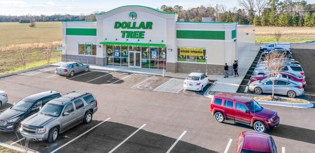
Property Record
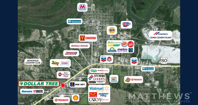
Highway 80 W, Demopolis, AL 36732

NEARBY LISTINGS FOR SALE OR LEASE
-
-
View all Demopolis listings for sale on LoopNet.com
Property Detail
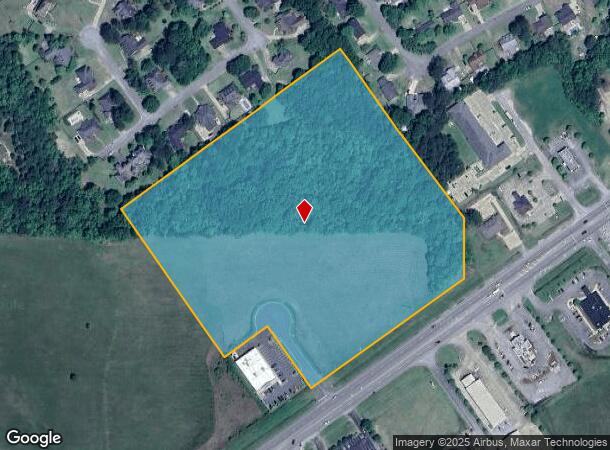
Highway 80 W
02-07-26-4-001-002-0000
15 AC COM @ SW COR OF LOT 37 FOREST BROOK ESTATES 3 FOR POB SE 597.26', NE 175', SE 250' TO HWY 80, NE ALG R/W 620', N 199',
Vacantlandnec
Marengo
X
Alabama
01091C0126F
37
2025
12 AC
2024
Alabama South Area
973400
Other Market Areas
DEMOGRAPHICS near Highway 80 W
1 Mile
3 Mile
5 Mile
2024 Total Population
2,174
6,493
7,378
2029 Population
2,068
6,224
7,076
Pop Growth 2024-2029
(4.88%)
(4.14%)
(4.09%)
Average Age
42
40
40
2024 Total Households
897
2,735
3,108
HH Growth 2024-2029
(4.46%)
(3.73%)
(3.70%)
Median Household Inc
$77,664
$34,060
$36,111
Avg Household Size
2.40
2.30
2.30
2024 Avg HH Vehicles
2.00
1.00
1.00
Median Home Value
$234,649
$173,721
$164,850
Median Year Built
1977
1981
1982
Nearby Places
Map Layers
Map Styles
 Street
 Aerial
- Restaurants
- Banks
- Shops
- Fitness
- Groceries
SALE & LEASE HISTORY
LISTING DATE
SALE/LEASE

May 21, 2020
For Sale
Nearby Properties
Address
Land Use
TOTAL SIZE
Lot Size
Zoning
Address
Land Use
TOTAL SIZE
Lot Size
Zoning
8,500 SF
43 AC
Address
Land Use
TOTAL SIZE
Lot Size
Zoning
151,562 SF
21.93 AC
Address
Land Use
TOTAL SIZE
Lot Size
Zoning
4,200 SF
41 AC
Address
Land Use
TOTAL SIZE
Lot Size
Zoning
3,640 SF
6.80 AC
Address
Land Use
TOTAL SIZE
Lot Size
Zoning
63,431 SF
10.13 AC
Address
Land Use
TOTAL SIZE
Lot Size
Zoning
40,000 SF
5.76 AC
Address
Land Use
TOTAL SIZE
Lot Size
Zoning
12,828 SF
2.10 AC
Address
Land Use
TOTAL SIZE
Lot Size
Zoning
49,357 SF
6.60 AC
Address
Land Use
TOTAL SIZE
Lot Size
Zoning
4,082 SF
6.14 AC
Address
Land Use
TOTAL SIZE
Lot Size
Zoning
9,724 SF
2.52 AC
Address
Land Use
TOTAL SIZE
Lot Size
Zoning
5,040 SF
3.93 AC
Address
Land Use
TOTAL SIZE
Lot Size
Zoning
9,472 SF
1.75 AC
Address
Land Use
TOTAL SIZE
Lot Size
Zoning
31,020 SF
3.12 AC
Address
Land Use
TOTAL SIZE
Lot Size
Zoning
4,287 SF
1.02 AC
Address
Land Use
TOTAL SIZE
Lot Size
Zoning
1,075 SF
5.60 AC
Address
Land Use
TOTAL SIZE
Lot Size
Zoning
10,794 SF
1.20 AC
Address
Land Use
TOTAL SIZE
Lot Size
Zoning
4,028 SF
11 AC
Address
Land Use
TOTAL SIZE
Lot Size
Zoning
54,189 SF
9.70 AC
Address
Land Use
TOTAL SIZE
Lot Size
Zoning
7,685 SF
1.59 AC
Address
Land Use
TOTAL SIZE
Lot Size
Zoning
6,000 SF
2.43 AC
Address
Land Use
TOTAL SIZE
Lot Size
Zoning
7,517 SF
1.87 AC
Address
Land Use
TOTAL SIZE
Lot Size
Zoning
19,082 SF
3.92 AC
Address
Land Use
TOTAL SIZE
Lot Size
Zoning
51,975 SF
1.83 AC
Address
Land Use
TOTAL SIZE
Lot Size
Zoning
22,240 SF
5.91 AC
Address
Land Use
TOTAL SIZE
Lot Size
Zoning
4,119 SF
1.05 AC
Address
Land Use
TOTAL SIZE
Lot Size
Zoning
21,500 SF
4.07 AC
Address
Land Use
TOTAL SIZE
Lot Size
Zoning
13,080 SF
1.12 AC
Address
Land Use
TOTAL SIZE
Lot Size
Zoning
4,434 SF
71 AC
Address
Land Use
TOTAL SIZE
Lot Size
Zoning
43,686 SF
0.99 AC
Address
Land Use
TOTAL SIZE
Lot Size
Zoning
5,782 SF
4.27 AC
The World's #1 Commercial Real Estate Marketplace
Connect with us
© 2026 CoStar Group
The information above has been obtained from sources believed reliable. While we do not doubt its accuracy we have not verified it and make no guarantee, warranty or representation about it. It is your responsibility to independently confirm its accuracy and completeness. Any projections, opinions, assumptions, or estimates used are for example only and do not represent the current or future performance of the property. The value of this transaction to you depends on tax and other factors which should be evaluated by your tax, financial, and legal advisors. You and your advisors should conduct a careful, independent investigation of the property to determine to your satisfaction the suitability of the property for your needs.