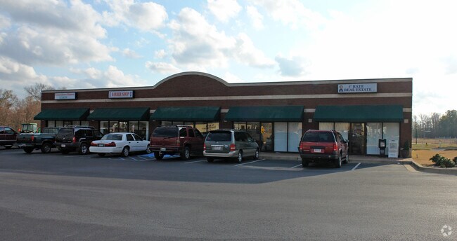
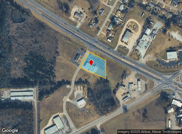
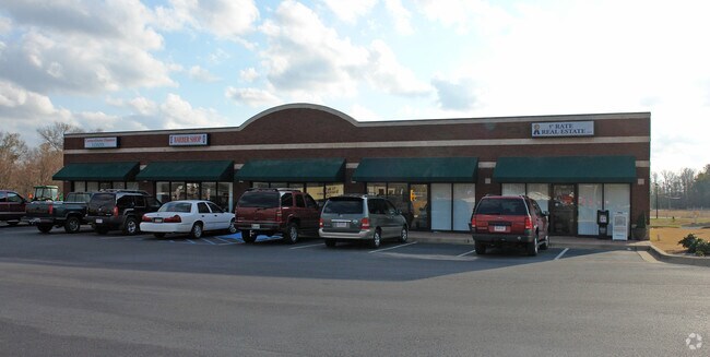
Property Record
Highway 82 W, Prattville, AL 36067
NEARBY LISTINGS FOR SALE OR LEASE
Property Detail
Highway 82 W
Montgomery, AL
Country Club Estates
19-04-20-1-005-021-047-0
LOT 1 COUNTRY CLUB COMM PARK PLAT 1 MAP BK 5 PG 235 CORRECTED MAP BK 2008 PG 12199.83 X 177.98 IRR 1.08 AC
Retailwithmorethanonenonretailuse
Autauga
X
Alabama
01051C0425F
1
2025
1.11 AC
2025
Prattville/Millbrook
020803
Montgomery
5,050 SF
DEMOGRAPHICS near Highway 82 W
1 Mile
3 Mile
5 Mile
2024 Total Population
3,377
18,510
39,531
2029 Population
3,530
19,225
41,064
Pop Growth 2024-2029
+ 4.53%
+ 3.86%
+ 3.88%
Average Age
39
40
39
2024 Total Households
1,280
7,153
15,347
HH Growth 2024-2029
+ 4.53%
+ 3.84%
+ 3.79%
Median Household Inc
$47,268
$57,079
$63,160
Avg Household Size
2.60
2.50
2.50
2024 Avg HH Vehicles
2.00
2.00
2.00
Median Home Value
$157,276
$157,588
$185,334
Median Year Built
1983
1976
1991
Nearby Places
Map Layers
Map Styles
 Street
 Aerial
- Restaurants
- Banks
- Shops
- Fitness
- Groceries
PUBLIC TRANSPORTATION
AIRPORT
Montgomery Regional (Dannelly Field)
DRIVE
WALK
Distance
Montgomery Regional (Dannelly Field)
25 min
16.9 mi
Nearby Properties
Address
Land Use
TOTAL SIZE
Lot Size
Zoning
Address
Land Use
TOTAL SIZE
Lot Size
Zoning
350,626 SF
31.54 AC
Address
Land Use
TOTAL SIZE
Lot Size
Zoning
84,255 SF
4.19 AC
Address
Land Use
TOTAL SIZE
Lot Size
Zoning
25,521 SF
18 AC
Address
Land Use
TOTAL SIZE
Lot Size
Zoning
33,043 SF
1.30 AC
Address
Land Use
TOTAL SIZE
Lot Size
Zoning
31,020 SF
2.90 AC
Address
Land Use
TOTAL SIZE
Lot Size
Zoning
191.98 AC
Address
Land Use
TOTAL SIZE
Lot Size
Zoning
19.93 AC
Address
Land Use
TOTAL SIZE
Lot Size
Zoning
100,000 SF
6.60 AC
Address
Land Use
TOTAL SIZE
Lot Size
Zoning
37,458 SF
0.74 AC
Address
Land Use
TOTAL SIZE
Lot Size
Zoning
85,080 SF
13.10 AC
Address
Land Use
TOTAL SIZE
Lot Size
Zoning
123,917 SF
25 AC
Address
Land Use
TOTAL SIZE
Lot Size
Zoning
76,340 SF
7.21 AC
Address
Land Use
TOTAL SIZE
Lot Size
Zoning
61,243 SF
5.64 AC
Address
Land Use
TOTAL SIZE
Lot Size
Zoning
38,050 SF
5.80 AC
Address
Land Use
TOTAL SIZE
Lot Size
Zoning
13,029 SF
1.42 AC
Address
Land Use
TOTAL SIZE
Lot Size
Zoning
51,484 SF
7.20 AC
Address
Land Use
TOTAL SIZE
Lot Size
Zoning
Address
Land Use
TOTAL SIZE
Lot Size
Zoning
4,132 SF
2 AC
Address
Land Use
TOTAL SIZE
Lot Size
Zoning
14,447 SF
1.27 AC
Address
Land Use
TOTAL SIZE
Lot Size
Zoning
7,250 SF
4 AC
Address
Land Use
TOTAL SIZE
Lot Size
Zoning
41,250 SF
6.76 AC
Address
Land Use
TOTAL SIZE
Lot Size
Zoning
4,115 SF
6.99 AC
Address
Land Use
TOTAL SIZE
Lot Size
Zoning
169 AC
Address
Land Use
TOTAL SIZE
Lot Size
Zoning
127,931 SF
10 AC
Address
Land Use
TOTAL SIZE
Lot Size
Zoning
47,400 SF
10 AC
Address
Land Use
TOTAL SIZE
Lot Size
Zoning
5,380 SF
2.01 AC
Address
Land Use
TOTAL SIZE
Lot Size
Zoning
11,525 SF
0.99 AC
Address
Land Use
TOTAL SIZE
Lot Size
Zoning
106,875 SF
2.10 AC
Address
Land Use
TOTAL SIZE
Lot Size
Zoning
51,906 SF
3.98 AC
The World's #1 Commercial Real Estate Marketplace
Connect with us
© 2026 CoStar Group
The information above has been obtained from sources believed reliable. While we do not doubt its accuracy we have not verified it and make no guarantee, warranty or representation about it. It is your responsibility to independently confirm its accuracy and completeness. Any projections, opinions, assumptions, or estimates used are for example only and do not represent the current or future performance of the property. The value of this transaction to you depends on tax and other factors which should be evaluated by your tax, financial, and legal advisors. You and your advisors should conduct a careful, independent investigation of the property to determine to your satisfaction the suitability of the property for your needs.