Property Record
Highway 85, Senoia, GA 30276
NEARBY LISTINGS FOR SALE OR LEASE
-
-
View all Senoia listings for sale on LoopNet.com
Property Detail
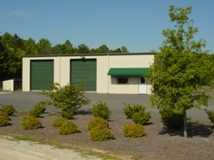
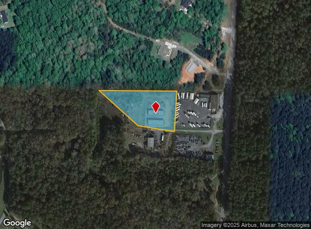
Highway 85
Atlanta-Sandy Springs-Roswell, GA
Rising Star
165-1240-019B
MINI WHSE/1.798 AC LT A3 LL 240 LD 1
Publicstorage
Coweta
X
Georgia
13077C0402D
a3
2025
1.80 AC
2025
Fayette/Coweta County
170502
Atlanta
5,000 SF
DEMOGRAPHICS near Highway 85
1 Mile
3 Mile
5 Mile
2024 Total Population
791
5,270
13,254
2029 Population
888
5,911
14,849
Pop Growth 2024-2029
+ 12.26%
+ 12.16%
+ 12.03%
Average Age
38
39
39
2024 Total Households
271
1,810
4,630
HH Growth 2024-2029
+ 12.18%
+ 12.27%
+ 12.05%
Median Household Inc
$84,298
$84,636
$85,850
Avg Household Size
2.90
2.90
2.80
2024 Avg HH Vehicles
2.00
2.00
2.00
Median Home Value
$372,727
$361,155
$341,321
Median Year Built
2002
2002
2002
Nearby Places
Map Layers
Map Styles
 Street
 Aerial
- Restaurants
- Banks
- Shops
- Fitness
- Groceries
PUBLIC TRANSPORTATION
AIRPORT
Hartsfield - Jackson Atlanta International
DRIVE
WALK
Distance
Hartsfield - Jackson Atlanta International
50 min
32.1 mi
Freight Ports
Georgia Ports - Savannah
DRIVE
WALK
Distance
Georgia Ports - Savannah
276 min
239.6 mi
Nearby Properties
Address
Land Use
TOTAL SIZE
Lot Size
Zoning
Address
Land Use
TOTAL SIZE
Lot Size
Zoning
66,635 SF
10.90 AC
RFA
Address
Land Use
TOTAL SIZE
Lot Size
Zoning
168 SF
367.25 AC
RFA
Address
Land Use
TOTAL SIZE
Lot Size
Zoning
413.22 AC
001
Address
Land Use
TOTAL SIZE
Lot Size
Zoning
14,630 SF
6.14 AC
RFA
Address
Land Use
TOTAL SIZE
Lot Size
Zoning
279.01 AC
R1
Address
Land Use
TOTAL SIZE
Lot Size
Zoning
510.05 AC
001
Address
Land Use
TOTAL SIZE
Lot Size
Zoning
9,244 SF
4.66 AC
RFA
Address
Land Use
TOTAL SIZE
Lot Size
Zoning
194.04 AC
RFA
Address
Land Use
TOTAL SIZE
Lot Size
Zoning
132.83 AC
RFA
Address
Land Use
TOTAL SIZE
Lot Size
Zoning
294.85 AC
001
Address
Land Use
TOTAL SIZE
Lot Size
Zoning
1,344 SF
126.50 AC
R1
Address
Land Use
TOTAL SIZE
Lot Size
Zoning
238.05 AC
RFA
Address
Land Use
TOTAL SIZE
Lot Size
Zoning
5,176 SF
136.70 AC
RFA
Address
Land Use
TOTAL SIZE
Lot Size
Zoning
7,398 SF
12.71 AC
RFA
Address
Land Use
TOTAL SIZE
Lot Size
Zoning
144.48 AC
RFA
Address
Land Use
TOTAL SIZE
Lot Size
Zoning
181.55 AC
001
Address
Land Use
TOTAL SIZE
Lot Size
Zoning
130 AC
RFA
Address
Land Use
TOTAL SIZE
Lot Size
Zoning
183.41 AC
001
Address
Land Use
TOTAL SIZE
Lot Size
Zoning
7,800 SF
12.01 AC
RFA
Address
Land Use
TOTAL SIZE
Lot Size
Zoning
121.40 AC
RFA
Address
Land Use
TOTAL SIZE
Lot Size
Zoning
8,916 SF
1.11 AC
RFA
Address
Land Use
TOTAL SIZE
Lot Size
Zoning
153.55 AC
001
Address
Land Use
TOTAL SIZE
Lot Size
Zoning
6,280 SF
1.88 AC
RFA
Address
Land Use
TOTAL SIZE
Lot Size
Zoning
2,565 SF
94.77 AC
R1
Address
Land Use
TOTAL SIZE
Lot Size
Zoning
111.02 AC
RFA
Address
Land Use
TOTAL SIZE
Lot Size
Zoning
177.10 AC
001
Address
Land Use
TOTAL SIZE
Lot Size
Zoning
202.50 AC
001
Address
Land Use
TOTAL SIZE
Lot Size
Zoning
207.50 AC
001
Address
Land Use
TOTAL SIZE
Lot Size
Zoning
54.62 AC
R1
Address
Land Use
TOTAL SIZE
Lot Size
Zoning
78.73 AC
R1
The World's #1 Commercial Real Estate Marketplace
Connect with us
© 2026 CoStar Group
The information above has been obtained from sources believed reliable. While we do not doubt its accuracy we have not verified it and make no guarantee, warranty or representation about it. It is your responsibility to independently confirm its accuracy and completeness. Any projections, opinions, assumptions, or estimates used are for example only and do not represent the current or future performance of the property. The value of this transaction to you depends on tax and other factors which should be evaluated by your tax, financial, and legal advisors. You and your advisors should conduct a careful, independent investigation of the property to determine to your satisfaction the suitability of the property for your needs.