Property Record
Highway 9, Old Bridge, NJ 08857
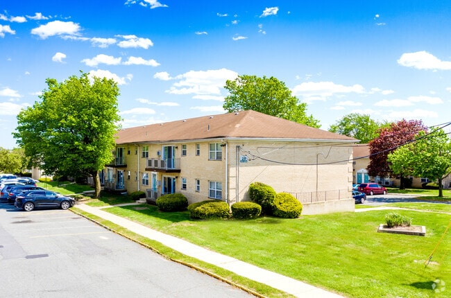

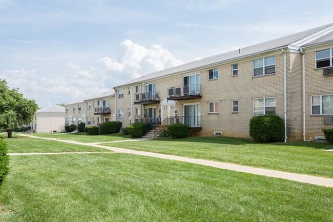
Property Detail
Highway 9
15-04185-0000-00010
69.62AC
Apartment
MIDDLESEX
AF
New Jersey
AE The base floodplain where base flood elevations are provided. AE Zones are now used on new format FIRMs instead of A1-A30 Zones.
10
2024
69.62 AC
2025
Turnpike East
007805
Northern New Jersey
7,904 SF
Lakewood-New Brunswick, NJ
NEARBY LISTINGS FOR SALE OR LEASE
-
-
View all Old Bridge listings for sale on LoopNet.com
DEMOGRAPHICS near Highway 9
1 mile
3 mile
5 mile
2025 Total Population
13,669
71,427
196,351
2030 Population
14,135
74,421
202,486
Pop Growth 2025-2030
+ 3.41%
+ 4.19%
+ 3.12%
Average Age
40
42
41
2025 Total Households
5,443
27,762
72,074
HH Growth 2025-2030
+ 3.62%
+ 4.29%
+ 3.25%
Median Household Inc
$81,847
$94,482
$99,232
Avg Household Size
2.50
2.50
2.70
2025 Avg HH Vehicles
2.00
2.00
2.00
Median Home Value
$444,729
$431,540
$463,494
Median Year Built
1966
1970
1968
Nearby Places
Map Layers
Map Styles
 Street
 Aerial
Transit
 Traffic
 Biking
Places
Listings with unknown addresses are not visible on the map
- Restaurants
- Banks
- Shops
- Fitness
- Groceries
PUBLIC TRANSPORTATION
COMMUTER RAIL
South Amboy (North Jersey Coast Line - NJ Transit Commuter Rail (NJ Transit))
Drive
Walk
Distance
South Amboy (North Jersey Coast Line - NJ Transit Commuter Rail (NJ Transit))
7 min
3.7 mi
Aberdeen Matawan (North Jersey Coast Line - NJ Transit Commuter Rail (NJ Transit))
Drive
Walk
Distance
Aberdeen Matawan (North Jersey Coast Line - NJ Transit Commuter Rail (NJ Transit))
11 min
6.4 mi
AIRPORT
Newark Liberty International
Drive
Walk
Distance
Newark Liberty International
34 min
27.2 mi
Trenton Mercer
Drive
Walk
Distance
Trenton Mercer
59 min
43.4 mi
Freight Ports
New York Container Terminal
Drive
Walk
Distance
New York Container Terminal
27 min
19.4 mi
Nearby Properties
Address
Land Use
TOTAL SIZE
Lot Size
Zoning
Address
Land Use
TOTAL SIZE
Lot Size
Zoning
0.28 AC
CBD
Address
Land Use
TOTAL SIZE
Lot Size
Zoning
Address
Land Use
TOTAL SIZE
Lot Size
Zoning
286,949 SF
2.14 AC
C-4
Address
Land Use
TOTAL SIZE
Lot Size
Zoning
Address
Land Use
TOTAL SIZE
Lot Size
Zoning
Address
Land Use
TOTAL SIZE
Lot Size
Zoning
726 SF
75.46 AC
P
Address
Land Use
TOTAL SIZE
Lot Size
Zoning
7,904 SF
60 AC
AF
Address
Land Use
TOTAL SIZE
Lot Size
Zoning
Address
Land Use
TOTAL SIZE
Lot Size
Zoning
7,904 SF
39.92 AC
TCD
Address
Land Use
TOTAL SIZE
Lot Size
Zoning
31.22 AC
G1
Address
Land Use
TOTAL SIZE
Lot Size
Zoning
1.58 AC
Address
Land Use
TOTAL SIZE
Lot Size
Zoning
3.29 AC
M1
Address
Land Use
TOTAL SIZE
Lot Size
Zoning
7,904 SF
38.30 AC
AF
Address
Land Use
TOTAL SIZE
Lot Size
Zoning
136,121 SF
12.84 AC
RB
Address
Land Use
TOTAL SIZE
Lot Size
Zoning
329.22 AC
I
Address
Land Use
TOTAL SIZE
Lot Size
Zoning
Address
Land Use
TOTAL SIZE
Lot Size
Zoning
7,905 SF
26.55 AC
CC
Address
Land Use
TOTAL SIZE
Lot Size
Zoning
Address
Land Use
TOTAL SIZE
Lot Size
Zoning
169.71 AC
I
Address
Land Use
TOTAL SIZE
Lot Size
Zoning
7,904 SF
30 AC
AF
Address
Land Use
TOTAL SIZE
Lot Size
Zoning
7,905 SF
22.82 AC
CC
Address
Land Use
TOTAL SIZE
Lot Size
Zoning
7,801 SF
39.88 AC
AF
Address
Land Use
TOTAL SIZE
Lot Size
Zoning
7,801 SF
33.28 AC
AF
Address
Land Use
TOTAL SIZE
Lot Size
Zoning
7,904 SF
14.66 AC
R15
Address
Land Use
TOTAL SIZE
Lot Size
Zoning
19.97 AC
P
Address
Land Use
TOTAL SIZE
Lot Size
Zoning
95.75 AC
I
Address
Land Use
TOTAL SIZE
Lot Size
Zoning
8,000 SF
312.58 AC
ER
Address
Land Use
TOTAL SIZE
Lot Size
Zoning
775 SF
26.95 AC
RAWDIK
Address
Land Use
TOTAL SIZE
Lot Size
Zoning
3,850 SF
22.94 AC
G1
The World's #1 Commercial Real Estate Marketplace
Connect with us
© 2026 CoStar Group
The information above has been obtained from sources believed reliable. While we do not doubt its accuracy we have not verified it and make no guarantee, warranty or representation about it. It is your responsibility to independently confirm its accuracy and completeness. Any projections, opinions, assumptions, or estimates used are for example only and do not represent the current or future performance of the property. The value of this transaction to you depends on tax and other factors which should be evaluated by your tax, financial, and legal advisors. You and your advisors should conduct a careful, independent investigation of the property to determine to your satisfaction the suitability of the property for your needs.