Property Record
Highway 90 W, Baker, FL 32531

Property Detail
Highway 90 W
Crestview-Fort Walton Beach-Destin, FL
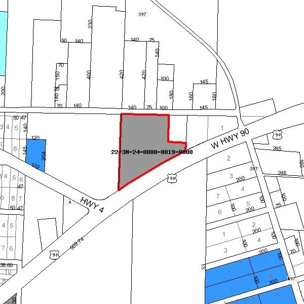
COM NE COR OF NE1/4 OF NW1/4 S 178.41FT TO C/L HWY 90 THC SWLY 601.63FT N 33 DEG W 50FT TO N R/W HWY 90 N 19.61FT TO POB CONT SWLY 85.49FT S 78 DEG W 188.03FT N 61 DEG W 279.86FT N 75.37FT N 56.25FT S 61 DEG E 219.73FT N 184.91FT E 307.67FT S 254.28F
22-3N-24-0000-0019-0000
OKALOOSA
Vacantlandnec
Florida
C and X Area of minimal flood hazard, usually depicted on FIRMs as above the 500-year flood level.
2.11 AC
2025
Fort Walton Beach
2025
Other Market Areas
020101
NEARBY LISTINGS FOR SALE OR LEASE
DEMOGRAPHICS near Highway 90 W
1 mile
3 mile
5 mile
2025 Total Population
511
8,022
31,802
2030 Population
533
8,270
32,765
Pop Growth 2025-2030
+ 4.31%
+ 3.09%
+ 3.03%
Average Age
41
37
37
2025 Total Households
189
2,894
11,599
HH Growth 2025-2030
+ 4.23%
+ 2.80%
+ 2.83%
Median Household Inc
$84,434
$94,210
$78,303
Avg Household Size
2.60
2.70
2.60
2025 Avg HH Vehicles
2.00
2.00
2.00
Median Home Value
$349,206
$342,413
$310,698
Median Year Built
2002
2004
2000
Nearby Places
Map Layers
Map Styles
 Street
 Aerial
Layers
 Traffic
 Biking
Places
Listings with unknown addresses are not visible on the map
- Restaurants
- Banks
- Shops
- Fitness
- Groceries
PUBLIC TRANSPORTATION
AIRPORT
Eglin AFB/Destin-Ft Walton Beach
Drive
Walk
Distance
Eglin AFB/Destin-Ft Walton Beach
51 min
28.4 mi
Freight Ports
Port of Panama City
Drive
Walk
Distance
Port of Panama City
119 min
90.7 mi
Nearby Properties
Address
Land Use
TOTAL SIZE
Lot Size
Zoning
Address
Land Use
TOTAL SIZE
Lot Size
Zoning
124,093 SF
6.94 AC
R-2
Address
Land Use
TOTAL SIZE
Lot Size
Zoning
143,873 SF
20.26 AC
Address
Land Use
TOTAL SIZE
Lot Size
Zoning
233,285 SF
11.45 AC
C-1
Address
Land Use
TOTAL SIZE
Lot Size
Zoning
7,615 SF
70.60 AC
Address
Land Use
TOTAL SIZE
Lot Size
Zoning
113,123 SF
20.45 AC
C-1
Address
Land Use
TOTAL SIZE
Lot Size
Zoning
33,162 SF
4.48 AC
Address
Land Use
TOTAL SIZE
Lot Size
Zoning
23,621 SF
126.86 AC
Address
Land Use
TOTAL SIZE
Lot Size
Zoning
39,937 SF
51.25 AC
Address
Land Use
TOTAL SIZE
Lot Size
Zoning
143.65 AC
Address
Land Use
TOTAL SIZE
Lot Size
Zoning
48,957 SF
20.60 AC
Address
Land Use
TOTAL SIZE
Lot Size
Zoning
12,224 SF
2.08 AC
Address
Land Use
TOTAL SIZE
Lot Size
Zoning
18,355 SF
9.25 AC
Address
Land Use
TOTAL SIZE
Lot Size
Zoning
14,175 SF
8.72 AC
Address
Land Use
TOTAL SIZE
Lot Size
Zoning
25,318 SF
0.80 AC
Address
Land Use
TOTAL SIZE
Lot Size
Zoning
7,950 SF
12.31 AC
Address
Land Use
TOTAL SIZE
Lot Size
Zoning
13,398 SF
108.17 AC
Address
Land Use
TOTAL SIZE
Lot Size
Zoning
11,020 SF
0.80 AC
Address
Land Use
TOTAL SIZE
Lot Size
Zoning
6,831 SF
152.02 AC
Address
Land Use
TOTAL SIZE
Lot Size
Zoning
11,204 SF
1.20 AC
Address
Land Use
TOTAL SIZE
Lot Size
Zoning
18,980 SF
1.75 AC
Address
Land Use
TOTAL SIZE
Lot Size
Zoning
2,275 SF
1.72 AC
Address
Land Use
TOTAL SIZE
Lot Size
Zoning
8,567 SF
2.31 AC
Address
Land Use
TOTAL SIZE
Lot Size
Zoning
6,110 SF
0.84 AC
Address
Land Use
TOTAL SIZE
Lot Size
Zoning
9,230 SF
2 AC
Address
Land Use
TOTAL SIZE
Lot Size
Zoning
26,909 SF
0.93 AC
Address
Land Use
TOTAL SIZE
Lot Size
Zoning
6,225 SF
10.32 AC
Address
Land Use
TOTAL SIZE
Lot Size
Zoning
4,334 SF
15.27 AC
Address
Land Use
TOTAL SIZE
Lot Size
Zoning
3,276 SF
0.98 AC
Address
Land Use
TOTAL SIZE
Lot Size
Zoning
6,285 SF
19.81 AC
Address
Land Use
TOTAL SIZE
Lot Size
Zoning
2,160 SF
184.86 AC
The World's #1 Commercial Real Estate Marketplace
Connect with us
© 2026 CoStar Group
The information above has been obtained from sources believed reliable. While we do not doubt its accuracy we have not verified it and make no guarantee, warranty or representation about it. It is your responsibility to independently confirm its accuracy and completeness. Any projections, opinions, assumptions, or estimates used are for example only and do not represent the current or future performance of the property. The value of this transaction to you depends on tax and other factors which should be evaluated by your tax, financial, and legal advisors. You and your advisors should conduct a careful, independent investigation of the property to determine to your satisfaction the suitability of the property for your needs.