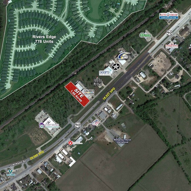
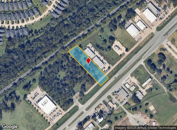
Property Record
Highway 90A, Richmond, TX 77406
NEARBY LISTINGS FOR SALE OR LEASE
Property Detail
Highway 90A
Houston-The Woodlands-Sugar Land, TX
Richmond Landing Sec 3
6186-03-000-0190-901
RICHMOND LANDING SEC 3, BLOCK 1, ACRES 1.633, RESERVE U
Residentialacreage
Fort Bend
AE
Texas
48157C0235L
1.63 AC
2024
Southwest Outlier
2025
Houston
673404
DEMOGRAPHICS near Highway 90A
1 Mile
3 Mile
5 Mile
2024 Total Population
4,724
52,525
165,116
2029 Population
5,787
63,407
199,338
Pop Growth 2024-2029
+ 22.50%
+ 20.72%
+ 20.73%
Average Age
39
40
38
2024 Total Households
1,550
18,781
54,688
HH Growth 2024-2029
+ 23.29%
+ 21.76%
+ 21.53%
Median Household Inc
$79,195
$72,966
$89,208
Avg Household Size
2.90
2.70
2.90
2024 Avg HH Vehicles
3.00
2.00
2.00
Median Home Value
$300,139
$295,807
$307,282
Median Year Built
2003
2002
2003
Nearby Places
Map Layers
Map Styles
 Street
 Aerial
- Restaurants
- Banks
- Shops
- Fitness
- Groceries
PUBLIC TRANSPORTATION
AIRPORT
William P Hobby
DRIVE
WALK
Distance
William P Hobby
52 min
33.0 mi
Freight Ports
Port of Houston
DRIVE
WALK
Distance
Port of Houston
52 min
35.1 mi
SALE & LEASE HISTORY
LISTING DATE
SALE/LEASE

Nov 15, 2016
For Sale
Dec 21, 2017
For Sale
Dec 19, 2019
For Sale
Apr 04, 2017
For Sale
Nearby Properties
Address
Land Use
TOTAL SIZE
Lot Size
Zoning
Address
Land Use
TOTAL SIZE
Lot Size
Zoning
449,167 SF
73.44 AC
IY
Address
Land Use
TOTAL SIZE
Lot Size
Zoning
504,838 SF
30.59 AC
Address
Land Use
TOTAL SIZE
Lot Size
Zoning
10.84 AC
Address
Land Use
TOTAL SIZE
Lot Size
Zoning
Address
Land Use
TOTAL SIZE
Lot Size
Zoning
438,371 SF
132.75 AC
Address
Land Use
TOTAL SIZE
Lot Size
Zoning
78,077 SF
16.29 AC
Address
Land Use
TOTAL SIZE
Lot Size
Zoning
85,021 SF
12 AC
Address
Land Use
TOTAL SIZE
Lot Size
Zoning
81,128 SF
8.98 AC
YNQS
Address
Land Use
TOTAL SIZE
Lot Size
Zoning
212,000 SF
0.49 AC
Address
Land Use
TOTAL SIZE
Lot Size
Zoning
169,798 SF
16.29 AC
Address
Land Use
TOTAL SIZE
Lot Size
Zoning
224,099 SF
11.85 AC
Address
Land Use
TOTAL SIZE
Lot Size
Zoning
Address
Land Use
TOTAL SIZE
Lot Size
Zoning
3,680 SF
38.68 AC
SMH
Address
Land Use
TOTAL SIZE
Lot Size
Zoning
20,000,000 SF
5 AC
Address
Land Use
TOTAL SIZE
Lot Size
Zoning
96,992 SF
14.76 AC
SM
Address
Land Use
TOTAL SIZE
Lot Size
Zoning
2,131 SF
17.68 AC
Address
Land Use
TOTAL SIZE
Lot Size
Zoning
28.37 AC
Z
Address
Land Use
TOTAL SIZE
Lot Size
Zoning
94,080 SF
6.23 AC
H
Address
Land Use
TOTAL SIZE
Lot Size
Zoning
132,171 SF
8.86 AC
Address
Land Use
TOTAL SIZE
Lot Size
Zoning
46,959 SF
8.36 AC
S
Address
Land Use
TOTAL SIZE
Lot Size
Zoning
103,380 SF
5.44 AC
NYX
Address
Land Use
TOTAL SIZE
Lot Size
Zoning
103,204 SF
5.50 AC
YX
Address
Land Use
TOTAL SIZE
Lot Size
Zoning
250,000 SF
1.01 AC
Address
Land Use
TOTAL SIZE
Lot Size
Zoning
Address
Land Use
TOTAL SIZE
Lot Size
Zoning
92,210 SF
12.09 AC
Address
Land Use
TOTAL SIZE
Lot Size
Zoning
8.32 AC
NTQXS
Address
Land Use
TOTAL SIZE
Lot Size
Zoning
202,234 SF
30.07 AC
S
Address
Land Use
TOTAL SIZE
Lot Size
Zoning
6.99 AC
Address
Land Use
TOTAL SIZE
Lot Size
Zoning
88,640 SF
5.59 AC
Address
Land Use
TOTAL SIZE
Lot Size
Zoning
4,536 SF
3.74 AC
Y
The World's #1 Commercial Real Estate Marketplace
Connect with us
© 2025 CoStar Group
The information above has been obtained from sources believed reliable. While we do not doubt its accuracy we have not verified it and make no guarantee, warranty or representation about it. It is your responsibility to independently confirm its accuracy and completeness. Any projections, opinions, assumptions, or estimates used are for example only and do not represent the current or future performance of the property. The value of this transaction to you depends on tax and other factors which should be evaluated by your tax, financial, and legal advisors. You and your advisors should conduct a careful, independent investigation of the property to determine to your satisfaction the suitability of the property for your needs.