Property Record
Highway 95A, Fernley, NV 89408
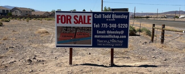
This Property Is For Sale
NEARBY LISTINGS FOR SALE OR LEASE
Property Detail
Highway 95A
Fernley, NV
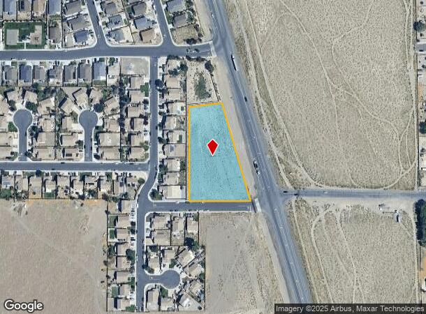
Parcel Map For Columbia Properties Llc
021-542-11
25-20-24 FR NW4 PAR B ADJ CREATED FROM SPLIT OF PARCEL # 021-542-04 PRIMARY NEW PARCEL IS PARCEL # 021-542-10 BIG OAKS DR SPLIT THE PROPERTIES - LETTER REQUEST CHANGED FROM PARCEL # 021-542-09 PARCEL B ADJUSTED FROM BA 375505
Commercialacreage
Lyon
A
Nevada
32031C3175G
1.95 AC
2026
Lyon County
2025
Reno/Sparks
960101
DEMOGRAPHICS near Highway 95A
1 Mile
3 Mile
5 Mile
2024 Total Population
1,714
20,072
22,752
2029 Population
1,800
21,119
23,926
Pop Growth 2024-2029
+ 5.02%
+ 5.22%
+ 5.16%
Average Age
41
39
39
2024 Total Households
599
7,216
8,145
HH Growth 2024-2029
+ 5.18%
+ 5.24%
+ 5.18%
Median Household Inc
$107,948
$81,337
$82,599
Avg Household Size
2.90
2.80
2.80
2024 Avg HH Vehicles
2.00
2.00
2.00
Median Home Value
$408,529
$361,311
$362,909
Median Year Built
2004
2000
2000
Nearby Places
Map Layers
Map Styles
 Street
 Aerial
- Restaurants
- Banks
- Shops
- Fitness
- Groceries
PUBLIC TRANSPORTATION
AIRPORT
Reno/Tahoe International
DRIVE
WALK
Distance
Reno/Tahoe International
47 min
35.5 mi
Nearby Properties
Address
Land Use
TOTAL SIZE
Lot Size
Zoning
Address
Land Use
TOTAL SIZE
Lot Size
Zoning
8,799 SF
11.67 AC
MF30
Address
Land Use
TOTAL SIZE
Lot Size
Zoning
588,560 SF
34.94 AC
MULT
Address
Land Use
TOTAL SIZE
Lot Size
Zoning
112,125 SF
57.15 AC
GR20
Address
Land Use
TOTAL SIZE
Lot Size
Zoning
96,632 SF
19.48 AC
PF
Address
Land Use
TOTAL SIZE
Lot Size
Zoning
6,792 SF
21.50 AC
MU
Address
Land Use
TOTAL SIZE
Lot Size
Zoning
157,615 SF
16.36 AC
C2
Address
Land Use
TOTAL SIZE
Lot Size
Zoning
4,000 SF
34.40 AC
I
Address
Land Use
TOTAL SIZE
Lot Size
Zoning
20,935 SF
29.04 AC
MULT
Address
Land Use
TOTAL SIZE
Lot Size
Zoning
54,726 SF
10 AC
RR1
Address
Land Use
TOTAL SIZE
Lot Size
Zoning
4,474 SF
6.23 AC
PF
Address
Land Use
TOTAL SIZE
Lot Size
Zoning
52,100 SF
4.91 AC
C2
Address
Land Use
TOTAL SIZE
Lot Size
Zoning
188,220 SF
12.17 AC
I
Address
Land Use
TOTAL SIZE
Lot Size
Zoning
165,424 SF
8.32 AC
I
Address
Land Use
TOTAL SIZE
Lot Size
Zoning
111,142 SF
19.32 AC
I
Address
Land Use
TOTAL SIZE
Lot Size
Zoning
2,001 SF
10 AC
C2
Address
Land Use
TOTAL SIZE
Lot Size
Zoning
45,666 SF
5.92 AC
C2
Address
Land Use
TOTAL SIZE
Lot Size
Zoning
29,972 SF
4.76 AC
PF
Address
Land Use
TOTAL SIZE
Lot Size
Zoning
44,589 SF
1.95 AC
C2
Address
Land Use
TOTAL SIZE
Lot Size
Zoning
9,360 SF
3.48 AC
I
Address
Land Use
TOTAL SIZE
Lot Size
Zoning
33,840 SF
11.98 AC
I
Address
Land Use
TOTAL SIZE
Lot Size
Zoning
13,653 SF
10.34 AC
C2
Address
Land Use
TOTAL SIZE
Lot Size
Zoning
1,992 SF
6.01 AC
MULT
Address
Land Use
TOTAL SIZE
Lot Size
Zoning
25,624 SF
2.81 AC
MULT
Address
Land Use
TOTAL SIZE
Lot Size
Zoning
6,476 SF
3.44 AC
MF30
Address
Land Use
TOTAL SIZE
Lot Size
Zoning
18,694 SF
2.55 AC
PF
Address
Land Use
TOTAL SIZE
Lot Size
Zoning
13,851 SF
3.30 AC
C2
Address
Land Use
TOTAL SIZE
Lot Size
Zoning
1,908 SF
4,121.92 AC
GR20
Address
Land Use
TOTAL SIZE
Lot Size
Zoning
10,308 SF
9.07 AC
C2
Address
Land Use
TOTAL SIZE
Lot Size
Zoning
22,360 SF
5.03 AC
C2
Address
Land Use
TOTAL SIZE
Lot Size
Zoning
21,238 SF
1.98 AC
C2
The World's #1 Commercial Real Estate Marketplace
Connect with us
© 2026 CoStar Group
The information above has been obtained from sources believed reliable. While we do not doubt its accuracy we have not verified it and make no guarantee, warranty or representation about it. It is your responsibility to independently confirm its accuracy and completeness. Any projections, opinions, assumptions, or estimates used are for example only and do not represent the current or future performance of the property. The value of this transaction to you depends on tax and other factors which should be evaluated by your tax, financial, and legal advisors. You and your advisors should conduct a careful, independent investigation of the property to determine to your satisfaction the suitability of the property for your needs.