Property Record
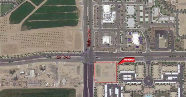
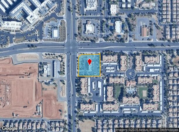
1633 S Higley Rd, Gilbert, AZ 85295

NEARBY LISTINGS FOR SALE OR LEASE
Property Detail
1633 S Higley Rd
304-39-016W
TH PT NW4 SEC 26 LY WI-IN TH PT DESC AS PARCEL 3 P/F 04-1210577 EX PERMITTED EXCEPTIONS AS DESC IN EXHIBIT A-2 P/F 04-1210577 & EX ANY PT LY WI-IN RAY RD & HIGLEY RD MOD MCR 74-16 & EX TH PT LY WI-IN LYONS GATE PHASE 6 MCR 783-12 TH PT NW4 SEC 26 DAF
Restaurantdrivein
Maricopa
X
Arizona
04013C2753M
1
2025
1.36 AC
2025
Gateway Airport/Loop 202
815203
Phoenix
3,557 SF
Phoenix-Mesa-Chandler, AZ
DEMOGRAPHICS near 1633 S Higley Rd
1 Mile
3 Mile
5 Mile
2024 Total Population
18,677
111,353
264,569
2029 Population
20,230
121,278
286,996
Pop Growth 2024-2029
+ 8.32%
+ 8.91%
+ 8.48%
Average Age
34
34
36
2024 Total Households
6,008
36,039
87,576
HH Growth 2024-2029
+ 8.37%
+ 9.17%
+ 8.65%
Median Household Inc
$114,208
$108,512
$104,851
Avg Household Size
3.10
3.00
3.00
2024 Avg HH Vehicles
2.00
2.00
2.00
Median Home Value
$429,865
$439,203
$442,363
Median Year Built
2007
2005
2001
Nearby Places
Map Layers
Map Styles
 Street
 Aerial
- Restaurants
- Banks
- Shops
- Fitness
- Groceries
PUBLIC TRANSPORTATION
AIRPORT
Phoenix-Mesa Gateway
DRIVE
WALK
Distance
Phoenix-Mesa Gateway
9 min
4.2 mi
Phoenix Sky Harbor International
DRIVE
WALK
Distance
Phoenix Sky Harbor International
37 min
24.7 mi
Nearby Properties
Address
Land Use
TOTAL SIZE
Lot Size
Zoning
Address
Land Use
TOTAL SIZE
Lot Size
Zoning
837,332 SF
55.22 AC
PF
Address
Land Use
TOTAL SIZE
Lot Size
Zoning
Address
Land Use
TOTAL SIZE
Lot Size
Zoning
93,214 SF
10.60 AC
PF
Address
Land Use
TOTAL SIZE
Lot Size
Zoning
862,568 SF
420.15 AC
PS
Address
Land Use
TOTAL SIZE
Lot Size
Zoning
12.66 AC
Address
Land Use
TOTAL SIZE
Lot Size
Zoning
604,432 SF
56.74 AC
PF
Address
Land Use
TOTAL SIZE
Lot Size
Zoning
2.91 AC
Address
Land Use
TOTAL SIZE
Lot Size
Zoning
580,492 SF
41.81 AC
R3
Address
Land Use
TOTAL SIZE
Lot Size
Zoning
298,703 SF
57.08 AC
PF
Address
Land Use
TOTAL SIZE
Lot Size
Zoning
479,727 SF
14.25 AC
MFM
Address
Land Use
TOTAL SIZE
Lot Size
Zoning
245,425 SF
205.62 AC
I-1
Address
Land Use
TOTAL SIZE
Lot Size
Zoning
412,581 SF
21.15 AC
MFM
Address
Land Use
TOTAL SIZE
Lot Size
Zoning
4.60 AC
C-C
Address
Land Use
TOTAL SIZE
Lot Size
Zoning
396,754 SF
46.84 AC
PF
Address
Land Use
TOTAL SIZE
Lot Size
Zoning
414,288 SF
28.67 AC
LI
Address
Land Use
TOTAL SIZE
Lot Size
Zoning
348,668 SF
8.97 AC
R3
Address
Land Use
TOTAL SIZE
Lot Size
Zoning
238,386 SF
40.25 AC
BP
Address
Land Use
TOTAL SIZE
Lot Size
Zoning
387,535 SF
15.80 AC
C-G
Address
Land Use
TOTAL SIZE
Lot Size
Zoning
380,383 SF
14.79 AC
C-G
Address
Land Use
TOTAL SIZE
Lot Size
Zoning
323,064 SF
15.90 AC
MFM
Address
Land Use
TOTAL SIZE
Lot Size
Zoning
362,701 SF
9.77 AC
R3
Address
Land Use
TOTAL SIZE
Lot Size
Zoning
278,044 SF
19.98 AC
PF
Address
Land Use
TOTAL SIZE
Lot Size
Zoning
308,343 SF
13.90 AC
MFM
Address
Land Use
TOTAL SIZE
Lot Size
Zoning
266,467 SF
47.47 AC
PF
Address
Land Use
TOTAL SIZE
Lot Size
Zoning
274,993 SF
16.44 AC
Address
Land Use
TOTAL SIZE
Lot Size
Zoning
332,112 SF
15.44 AC
M-M
Address
Land Use
TOTAL SIZE
Lot Size
Zoning
275,813 SF
24.90 AC
R-CH
Address
Land Use
TOTAL SIZE
Lot Size
Zoning
316,979 SF
17.26 AC
MF/M
Address
Land Use
TOTAL SIZE
Lot Size
Zoning
283,393 SF
6 AC
GVC
Address
Land Use
TOTAL SIZE
Lot Size
Zoning
143,232 SF
26.94 AC
PF
The World's #1 Commercial Real Estate Marketplace
Connect with us
© 2026 CoStar Group
The information above has been obtained from sources believed reliable. While we do not doubt its accuracy we have not verified it and make no guarantee, warranty or representation about it. It is your responsibility to independently confirm its accuracy and completeness. Any projections, opinions, assumptions, or estimates used are for example only and do not represent the current or future performance of the property. The value of this transaction to you depends on tax and other factors which should be evaluated by your tax, financial, and legal advisors. You and your advisors should conduct a careful, independent investigation of the property to determine to your satisfaction the suitability of the property for your needs.