Property Record
Hill St, Laurel, MD 20723
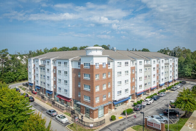

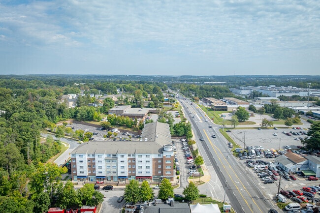
Property Detail
Hill St
Baltimore-Columbia-Towson, MD
PAR. A 2.3921 A. GCE HILL ST PATUXENT SQUARE
06-588441
HOWARD
Commercialcondominium
Maryland
CACLI
a
B and X Area of moderate flood hazard, usually the area between the limits of the 100-year and 500-year floods.
2.39 AC
0
North Laurel
2025
Baltimore
606907
NEARBY LISTINGS FOR SALE OR LEASE
-
-
View all Laurel listings for lease on LoopNet.com
DEMOGRAPHICS near Hill St
1 mile
3 mile
5 mile
2025 Total Population
15,282
92,935
176,614
2030 Population
15,475
94,168
179,599
Pop Growth 2025-2030
+ 1.26%
+ 1.33%
+ 1.69%
Average Age
37
38
38
2025 Total Households
5,527
34,621
64,413
HH Growth 2025-2030
+ 1.21%
+ 1.31%
+ 1.59%
Median Household Inc
$99,212
$100,676
$111,652
Avg Household Size
2.70
2.60
2.70
2025 Avg HH Vehicles
2.00
2.00
2.00
Median Home Value
$414,631
$423,980
$458,995
Median Year Built
1990
1986
1987
Nearby Places
Map Layers
Map Styles
 Street
 Aerial
Transit
 Traffic
 Biking
Places
Listings with unknown addresses are not visible on the map
- Restaurants
- Banks
- Shops
- Fitness
- Groceries
PUBLIC TRANSPORTATION
COMMUTER RAIL
Laurel Marc Sb (CAMDEN - WASHINGTON - Maryland Transit Administration)
Drive
Walk
Distance
Laurel Marc Sb (CAMDEN - WASHINGTON - Maryland Transit Administration)
4 min
1.2 mi
Laurel Racetrack Marc Sb (CAMDEN - WASHINGTON - Maryland Transit Administration)
Drive
Walk
Distance
Laurel Racetrack Marc Sb (CAMDEN - WASHINGTON - Maryland Transit Administration)
5 min
1.5 mi
AIRPORT
Baltimore/Washington International Thurgood Marshall
Drive
Walk
Distance
Baltimore/Washington International Thurgood Marshall
24 min
14.5 mi
Ronald Reagan Washington Ntl
Drive
Walk
Distance
Ronald Reagan Washington Ntl
43 min
26.3 mi
Freight Ports
Port of Baltimore
Drive
Walk
Distance
Port of Baltimore
29 min
18.7 mi
SALE & LEASE HISTORY
LISTING DATE
SALE/LEASE

Oct 07, 2020
For Lease
Dec 28, 2018
For Lease
Aug 16, 2017
For Lease
Nearby Properties
Address
Land Use
TOTAL SIZE
Lot Size
Zoning
Address
Land Use
TOTAL SIZE
Lot Size
Zoning
238,700 SF
7.43 AC
TOD
Address
Land Use
TOTAL SIZE
Lot Size
Zoning
399,715 SF
23.04 AC
LAUR
Address
Land Use
TOTAL SIZE
Lot Size
Zoning
657,100 SF
7.39 AC
LAUR
Address
Land Use
TOTAL SIZE
Lot Size
Zoning
796,368 SF
11.80 AC
R5
Address
Land Use
TOTAL SIZE
Lot Size
Zoning
279,320 SF
15.25 AC
R15
Address
Land Use
TOTAL SIZE
Lot Size
Zoning
261,969 SF
12.13 AC
R5R10
Address
Land Use
TOTAL SIZE
Lot Size
Zoning
104,067 SF
25.29 AC
RMF20
Address
Land Use
TOTAL SIZE
Lot Size
Zoning
14.84 AC
R-15
Address
Land Use
TOTAL SIZE
Lot Size
Zoning
165,236 SF
5.24 AC
LAUR
Address
Land Use
TOTAL SIZE
Lot Size
Zoning
379,264 SF
23.08 AC
LAUR
Address
Land Use
TOTAL SIZE
Lot Size
Zoning
539,758 SF
48.32 AC
M1
Address
Land Use
TOTAL SIZE
Lot Size
Zoning
16,016 SF
19.95 AC
RA15
Address
Land Use
TOTAL SIZE
Lot Size
Zoning
12,936 SF
19.50 AC
RA15
Address
Land Use
TOTAL SIZE
Lot Size
Zoning
302,887 SF
24.96 AC
LAUR
Address
Land Use
TOTAL SIZE
Lot Size
Zoning
364,609 SF
8.57 AC
R22
Address
Land Use
TOTAL SIZE
Lot Size
Zoning
418,818 SF
48.07 AC
C3
Address
Land Use
TOTAL SIZE
Lot Size
Zoning
16.36 AC
RMF20
Address
Land Use
TOTAL SIZE
Lot Size
Zoning
291,250 SF
30.09 AC
CECLI
Address
Land Use
TOTAL SIZE
Lot Size
Zoning
149,990 SF
10.41 AC
PEC
Address
Land Use
TOTAL SIZE
Lot Size
Zoning
91,666 SF
39.10 AC
RED
Address
Land Use
TOTAL SIZE
Lot Size
Zoning
149,990 SF
9.70 AC
PEC
Address
Land Use
TOTAL SIZE
Lot Size
Zoning
6,201 SF
71.87 AC
M 2
Address
Land Use
TOTAL SIZE
Lot Size
Zoning
304,575 SF
33.71 AC
TOD
Address
Land Use
TOTAL SIZE
Lot Size
Zoning
15.70 AC
RMF20
Address
Land Use
TOTAL SIZE
Lot Size
Zoning
13,624 SF
17.08 AC
RA15
Address
Land Use
TOTAL SIZE
Lot Size
Zoning
155,446 SF
10.76 AC
PEC
Address
Land Use
TOTAL SIZE
Lot Size
Zoning
489,896 SF
73.65 AC
M2
Address
Land Use
TOTAL SIZE
Lot Size
Zoning
56,148 SF
8.24 AC
PEC
Address
Land Use
TOTAL SIZE
Lot Size
Zoning
149,990 SF
6.40 AC
PEC
Address
Land Use
TOTAL SIZE
Lot Size
Zoning
61,198 SF
10.10 AC
PEC
The World's #1 Commercial Real Estate Marketplace
Connect with us
© 2026 CoStar Group
The information above has been obtained from sources believed reliable. While we do not doubt its accuracy we have not verified it and make no guarantee, warranty or representation about it. It is your responsibility to independently confirm its accuracy and completeness. Any projections, opinions, assumptions, or estimates used are for example only and do not represent the current or future performance of the property. The value of this transaction to you depends on tax and other factors which should be evaluated by your tax, financial, and legal advisors. You and your advisors should conduct a careful, independent investigation of the property to determine to your satisfaction the suitability of the property for your needs.