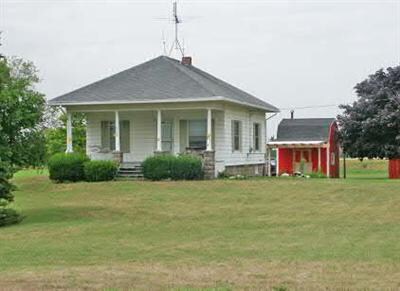
Property Record
Hillandale Rd, Sodus, MI 49126
NEARBY LISTINGS FOR SALE OR LEASE
-
-
View all Sodus listings for sale on LoopNet.com
Property Detail
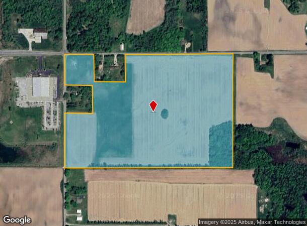
Hillandale Rd
11-19-0036-0017-03-6
THE NW1/4 OF NW1/4 & THE W1/2 OF NE1/4 OF NW1/4 SEC 36 T5S R18W EXC THE NE1/4 OF NW1/4 OF NW1/4 THEREOF ALSO EXC THAT PT LYING NLY & WLY OF FOL LN: COM 179.19' S1DEG18'28W OF NW COR SEC 36 TH S88DEG41'32"E 33' TH N57DEG50'43"E 185.19' THE ELY ON A LN
Agriculturalland
Berrien
X
Michigan
26021C0251C
54.27 AC
2024
Michigan Southwest Area
2025
Other Market Areas
001900
Niles-Benton Harbor, MI
DEMOGRAPHICS near Hillandale Rd
1 Mile
3 Mile
5 Mile
2024 Total Population
99
4,981
15,027
2029 Population
93
4,807
14,582
Pop Growth 2024-2029
(6.06%)
(3.49%)
(2.96%)
Average Age
44
38
40
2024 Total Households
38
1,548
5,403
HH Growth 2024-2029
(5.26%)
(4.39%)
(3.26%)
Median Household Inc
$55,000
$59,748
$67,234
Avg Household Size
2.40
2.50
2.50
2024 Avg HH Vehicles
2.00
2.00
2.00
Median Home Value
$185,713
$209,563
$221,760
Median Year Built
1948
1971
1973
Nearby Places
Map Layers
Map Styles
 Street
 Aerial
- Restaurants
- Banks
- Shops
- Fitness
- Groceries
PUBLIC TRANSPORTATION
AIRPORT
South Bend International
DRIVE
WALK
Distance
South Bend International
38 min
25.6 mi
Freight Ports
Port Milwaukee
DRIVE
WALK
Distance
Port Milwaukee
229 min
188.9 mi
Nearby Properties
Address
Land Use
TOTAL SIZE
Lot Size
Zoning
Address
Land Use
TOTAL SIZE
Lot Size
Zoning
28,992 SF
5.94 AC
B
Address
Land Use
TOTAL SIZE
Lot Size
Zoning
53,348 SF
4.19 AC
B
Address
Land Use
TOTAL SIZE
Lot Size
Zoning
9,836 SF
36.65 AC
AR
Address
Land Use
TOTAL SIZE
Lot Size
Zoning
18,310 SF
4.84 AC
B
Address
Land Use
TOTAL SIZE
Lot Size
Zoning
4,501 SF
4.22 AC
B
Address
Land Use
TOTAL SIZE
Lot Size
Zoning
230.64 AC
A - AG
Address
Land Use
TOTAL SIZE
Lot Size
Zoning
267.98 AC
R-A RE
Address
Land Use
TOTAL SIZE
Lot Size
Zoning
41,060 SF
21.99 AC
AG- AGR
Address
Land Use
TOTAL SIZE
Lot Size
Zoning
32,798 SF
31.14 AC
Address
Land Use
TOTAL SIZE
Lot Size
Zoning
3,600 SF
68.45 AC
R-A RE
Address
Land Use
TOTAL SIZE
Lot Size
Zoning
3,222 SF
1.06 AC
B
Address
Land Use
TOTAL SIZE
Lot Size
Zoning
19,020 SF
2.78 AC
B
Address
Land Use
TOTAL SIZE
Lot Size
Zoning
14,550 SF
12.91 AC
R-A RE
Address
Land Use
TOTAL SIZE
Lot Size
Zoning
2,166 SF
120 AC
AGRI / RES
Address
Land Use
TOTAL SIZE
Lot Size
Zoning
1,272 SF
138.04 AC
A - AG
Address
Land Use
TOTAL SIZE
Lot Size
Zoning
5,596 SF
145.14 AC
R-A RE
Address
Land Use
TOTAL SIZE
Lot Size
Zoning
2,442 SF
85.24 AC
AG
Address
Land Use
TOTAL SIZE
Lot Size
Zoning
2,544 SF
128.07 AC
A - AG
Address
Land Use
TOTAL SIZE
Lot Size
Zoning
2,314 SF
33.84 AC
R-A RE
Address
Land Use
TOTAL SIZE
Lot Size
Zoning
3,830 SF
40.73 AC
AR
Address
Land Use
TOTAL SIZE
Lot Size
Zoning
495 SF
5.01 AC
M
Address
Land Use
TOTAL SIZE
Lot Size
Zoning
5,016 SF
1.50 AC
B
Address
Land Use
TOTAL SIZE
Lot Size
Zoning
3,220 SF
2.06 AC
B
Address
Land Use
TOTAL SIZE
Lot Size
Zoning
6,530 SF
1.54 AC
B
Address
Land Use
TOTAL SIZE
Lot Size
Zoning
4,631 SF
33 AC
AR
Address
Land Use
TOTAL SIZE
Lot Size
Zoning
1,989 SF
39.87 AC
AR
Address
Land Use
TOTAL SIZE
Lot Size
Zoning
2,082 SF
75.05 AC
B
Address
Land Use
TOTAL SIZE
Lot Size
Zoning
12,045 SF
1.83 AC
UC
Address
Land Use
TOTAL SIZE
Lot Size
Zoning
1,967 SF
33.34 AC
Address
Land Use
TOTAL SIZE
Lot Size
Zoning
6,940 SF
2.68 AC
B
The World's #1 Commercial Real Estate Marketplace
Connect with us
© 2025 CoStar Group
The information above has been obtained from sources believed reliable. While we do not doubt its accuracy we have not verified it and make no guarantee, warranty or representation about it. It is your responsibility to independently confirm its accuracy and completeness. Any projections, opinions, assumptions, or estimates used are for example only and do not represent the current or future performance of the property. The value of this transaction to you depends on tax and other factors which should be evaluated by your tax, financial, and legal advisors. You and your advisors should conduct a careful, independent investigation of the property to determine to your satisfaction the suitability of the property for your needs.