Property Record
Hillcrest Ave, Antioch, CA 94531
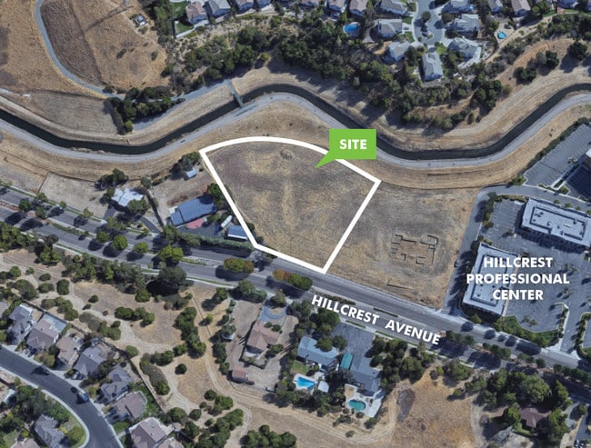


This Property Is For Sale
Property Detail
Hillcrest Ave
Oakland-Fremont-Berkeley, CA
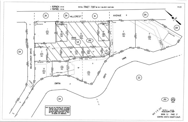
T7397 L9
052-370-009-4
CONTRA COSTA
Commercialacreage
California
B and X Area of moderate flood hazard, usually the area between the limits of the 100-year and 500-year floods.
9
2025
2.13 AC
2025
Antioch/Pittsburg
355110
East Bay/Oakland
NEARBY LISTINGS FOR SALE OR LEASE
DEMOGRAPHICS near Hillcrest Ave
1 mile
3 mile
5 mile
2025 Total Population
15,966
112,476
190,782
2030 Population
16,114
114,134
193,313
Pop Growth 2025-2030
+ 0.93%
+ 1.47%
+ 1.33%
Average Age
41
39
39
2025 Total Households
4,878
34,779
58,541
HH Growth 2025-2030
+ 0.94%
+ 1.50%
+ 1.34%
Median Household Inc
$112,293
$101,041
$110,889
Avg Household Size
3.20
3.10
3.20
2025 Avg HH Vehicles
3.00
2.00
2.00
Median Home Value
$730,642
$697,551
$715,150
Median Year Built
1989
1988
1991
Nearby Places
Map Layers
Map Styles
 Street
 Aerial
Transit
 Traffic
 Biking
Places
Listings with unknown addresses are not visible on the map
- Restaurants
- Banks
- Shops
- Fitness
- Groceries
PUBLIC TRANSPORTATION
AIRPORT
Stockton Metro
Drive
Walk
Distance
Stockton Metro
59 min
38.0 mi
Metro Oakland International
Drive
Walk
Distance
Metro Oakland International
63 min
47.2 mi
Freight Ports
Port of Stockton
Drive
Walk
Distance
Port of Stockton
54 min
35.8 mi
Nearby Properties
Address
Land Use
TOTAL SIZE
Lot Size
Zoning
Address
Land Use
TOTAL SIZE
Lot Size
Zoning
340,300 SF
35.04 AC
Address
Land Use
TOTAL SIZE
Lot Size
Zoning
109,536 SF
24.93 AC
Address
Land Use
TOTAL SIZE
Lot Size
Zoning
24,286 SF
13.89 AC
Address
Land Use
TOTAL SIZE
Lot Size
Zoning
57.12 AC
Address
Land Use
TOTAL SIZE
Lot Size
Zoning
9,999 SF
32.23 AC
Address
Land Use
TOTAL SIZE
Lot Size
Zoning
198,470 SF
13.49 AC
Address
Land Use
TOTAL SIZE
Lot Size
Zoning
479,414 SF
30.53 AC
Address
Land Use
TOTAL SIZE
Lot Size
Zoning
28,078 SF
6.46 AC
Address
Land Use
TOTAL SIZE
Lot Size
Zoning
35,995 SF
91.24 AC
Address
Land Use
TOTAL SIZE
Lot Size
Zoning
449,174 SF
38.31 AC
Address
Land Use
TOTAL SIZE
Lot Size
Zoning
228,334 SF
30.34 AC
HI
Address
Land Use
TOTAL SIZE
Lot Size
Zoning
145,503 SF
25.05 AC
Address
Land Use
TOTAL SIZE
Lot Size
Zoning
497,235 SF
26.26 AC
Address
Land Use
TOTAL SIZE
Lot Size
Zoning
220,840 SF
13.67 AC
Address
Land Use
TOTAL SIZE
Lot Size
Zoning
37,834 SF
9.52 AC
Address
Land Use
TOTAL SIZE
Lot Size
Zoning
443,591 SF
23.43 AC
Address
Land Use
TOTAL SIZE
Lot Size
Zoning
97,310 SF
5.85 AC
Address
Land Use
TOTAL SIZE
Lot Size
Zoning
157,933 SF
19.04 AC
Address
Land Use
TOTAL SIZE
Lot Size
Zoning
168,442 SF
17.46 AC
Address
Land Use
TOTAL SIZE
Lot Size
Zoning
184,623 SF
6.59 AC
Address
Land Use
TOTAL SIZE
Lot Size
Zoning
16,775 SF
25.31 AC
Address
Land Use
TOTAL SIZE
Lot Size
Zoning
12,410 SF
5.38 AC
Address
Land Use
TOTAL SIZE
Lot Size
Zoning
40,054 SF
3.39 AC
Address
Land Use
TOTAL SIZE
Lot Size
Zoning
24,156 SF
14.47 AC
Address
Land Use
TOTAL SIZE
Lot Size
Zoning
77,491 SF
4.25 AC
Address
Land Use
TOTAL SIZE
Lot Size
Zoning
13,468 SF
8.77 AC
Address
Land Use
TOTAL SIZE
Lot Size
Zoning
5,584 SF
10.47 AC
Address
Land Use
TOTAL SIZE
Lot Size
Zoning
126,509 SF
11.47 AC
Address
Land Use
TOTAL SIZE
Lot Size
Zoning
147,868 SF
7.83 AC
Address
Land Use
TOTAL SIZE
Lot Size
Zoning
75,119 SF
3.26 AC
The World's #1 Commercial Real Estate Marketplace
Connect with us
© 2026 CoStar Group
The information above has been obtained from sources believed reliable. While we do not doubt its accuracy we have not verified it and make no guarantee, warranty or representation about it. It is your responsibility to independently confirm its accuracy and completeness. Any projections, opinions, assumptions, or estimates used are for example only and do not represent the current or future performance of the property. The value of this transaction to you depends on tax and other factors which should be evaluated by your tax, financial, and legal advisors. You and your advisors should conduct a careful, independent investigation of the property to determine to your satisfaction the suitability of the property for your needs.