Property Record
Hollingsworth Rd, Basehor, KS 66007

NEARBY LISTINGS FOR SALE OR LEASE
-
-
View all Basehor listings for sale on LoopNet.com
Property Detail
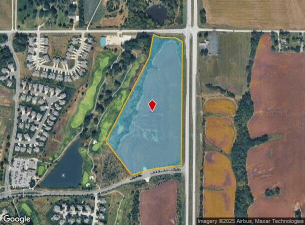
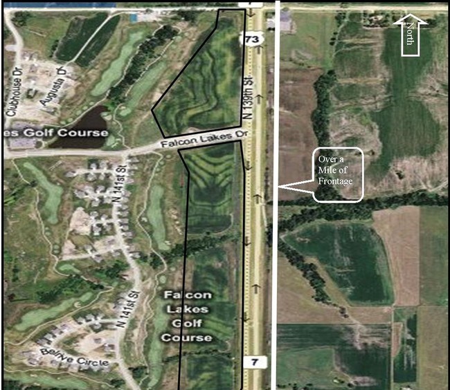
Hollingsworth Rd
156-24-0-00-01-001.00-0
S24, T10, R22E, ACRES 22.78, BEGINNING AT THE NE CORNER OF THE NE 1/4 OF S24. THEN S 1683 TO THE INTERSECTION OF FALCON LAKES DR AND 139TH, W ALONG CENTERLINE 640, NW 487, NE 520, NW 214, NE 428, N 348 TO HOLLINGSWORTH RD CENTERLINE, E TO POB. LE
Agriculturalland
Leavenworth
X
Kansas
20209C0020E
22.78 AC
2024
Leavenworth County
2025
Kansas City
071204
Kansas City, MO-KS
DEMOGRAPHICS near Hollingsworth Rd
1 Mile
3 Mile
5 Mile
2024 Total Population
1,293
8,285
28,167
2029 Population
1,347
8,311
28,138
Pop Growth 2024-2029
+ 4.18%
+ 0.31%
(0.10%)
Average Age
42
41
40
2024 Total Households
466
2,946
10,211
HH Growth 2024-2029
+ 4.29%
+ 0.51%
(0.17%)
Median Household Inc
$164,706
$121,710
$111,121
Avg Household Size
2.80
2.80
2.70
2024 Avg HH Vehicles
3.00
2.00
2.00
Median Home Value
$372,448
$350,983
$319,608
Median Year Built
2004
2000
2000
Nearby Places
Map Layers
Map Styles
 Street
 Aerial
- Restaurants
- Banks
- Shops
- Fitness
- Groceries
PUBLIC TRANSPORTATION
AIRPORT
Kansas City International
DRIVE
WALK
Distance
Kansas City International
34 min
24.9 mi
Freight Ports
Tulsa Port Of Catoosa
DRIVE
WALK
Distance
Tulsa Port Of Catoosa
278 min
248.0 mi
Nearby Properties
Address
Land Use
TOTAL SIZE
Lot Size
Zoning
Address
Land Use
TOTAL SIZE
Lot Size
Zoning
134,870 SF
73.61 AC
Address
Land Use
TOTAL SIZE
Lot Size
Zoning
77,925 SF
11.31 AC
Address
Land Use
TOTAL SIZE
Lot Size
Zoning
118,146 SF
19.85 AC
WR1B
Address
Land Use
TOTAL SIZE
Lot Size
Zoning
27,279 SF
17.93 AC
Address
Land Use
TOTAL SIZE
Lot Size
Zoning
39,215 SF
18.35 AC
Address
Land Use
TOTAL SIZE
Lot Size
Zoning
48,590 SF
4.72 AC
Address
Land Use
TOTAL SIZE
Lot Size
Zoning
26,000 SF
109.21 AC
WYAG
Address
Land Use
TOTAL SIZE
Lot Size
Zoning
27,568 SF
6.57 AC
WR1
Address
Land Use
TOTAL SIZE
Lot Size
Zoning
20,573 SF
4.60 AC
Address
Land Use
TOTAL SIZE
Lot Size
Zoning
9,100 SF
0.64 AC
Address
Land Use
TOTAL SIZE
Lot Size
Zoning
73.91 AC
Address
Land Use
TOTAL SIZE
Lot Size
Zoning
47.61 AC
WYAG
Address
Land Use
TOTAL SIZE
Lot Size
Zoning
33,125 SF
5.20 AC
Address
Land Use
TOTAL SIZE
Lot Size
Zoning
5,262 SF
1.94 AC
Address
Land Use
TOTAL SIZE
Lot Size
Zoning
17,592 SF
203.39 AC
WAG
Address
Land Use
TOTAL SIZE
Lot Size
Zoning
2,628 SF
19.44 AC
WAG
Address
Land Use
TOTAL SIZE
Lot Size
Zoning
251,824 SF
137.79 AC
WAG
Address
Land Use
TOTAL SIZE
Lot Size
Zoning
7,952 SF
1 AC
Address
Land Use
TOTAL SIZE
Lot Size
Zoning
3,801 SF
9.51 AC
WR1
Address
Land Use
TOTAL SIZE
Lot Size
Zoning
6,020 SF
0.75 AC
Address
Land Use
TOTAL SIZE
Lot Size
Zoning
18,156 SF
175.09 AC
Address
Land Use
TOTAL SIZE
Lot Size
Zoning
1,067 SF
14.86 AC
Address
Land Use
TOTAL SIZE
Lot Size
Zoning
38.93 AC
WAG
Address
Land Use
TOTAL SIZE
Lot Size
Zoning
19.81 AC
Address
Land Use
TOTAL SIZE
Lot Size
Zoning
22,672 SF
7.61 AC
Address
Land Use
TOTAL SIZE
Lot Size
Zoning
6,582 SF
2.06 AC
Address
Land Use
TOTAL SIZE
Lot Size
Zoning
1,296 SF
15.26 AC
Address
Land Use
TOTAL SIZE
Lot Size
Zoning
4,140 SF
2.16 AC
WR1B
Address
Land Use
TOTAL SIZE
Lot Size
Zoning
7,560 SF
13.70 AC
Address
Land Use
TOTAL SIZE
Lot Size
Zoning
46,765 SF
142.54 AC
WAG
The World's #1 Commercial Real Estate Marketplace
Connect with us
© 2025 CoStar Group
The information above has been obtained from sources believed reliable. While we do not doubt its accuracy we have not verified it and make no guarantee, warranty or representation about it. It is your responsibility to independently confirm its accuracy and completeness. Any projections, opinions, assumptions, or estimates used are for example only and do not represent the current or future performance of the property. The value of this transaction to you depends on tax and other factors which should be evaluated by your tax, financial, and legal advisors. You and your advisors should conduct a careful, independent investigation of the property to determine to your satisfaction the suitability of the property for your needs.