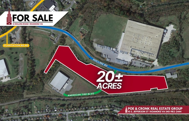
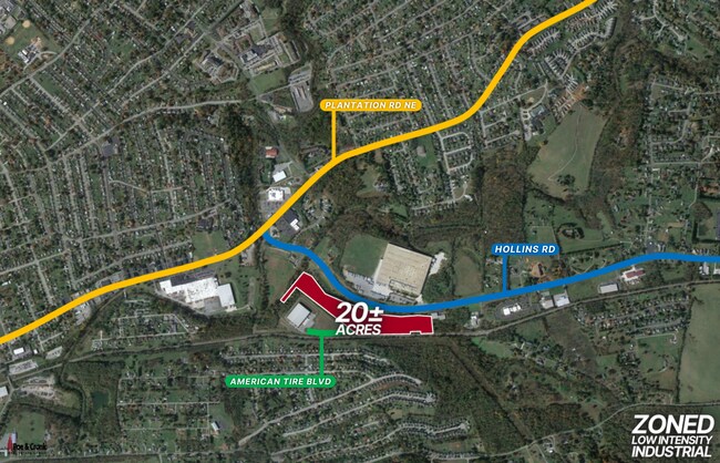
Property Record
4896 Hollins Rd, Roanoke, VA 24019
NEARBY LISTINGS FOR SALE OR LEASE
Property Detail
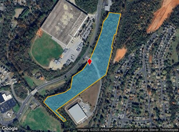
4896 Hollins Rd
038.16-01-03.01-0000
Hollins Plant Rd Commercial
Vacantlandnec
TR 2A RESUBD FOR HINMAN TRUST OFF HOLLINS RD
AE
Roanoke
51023C0460C
Virginia
2025
20.20 AC
2025
Northeast Roanoke
030203
Roanoke
2,056 SF
Roanoke, VA
DEMOGRAPHICS near 4896 Hollins Rd
1 Mile
3 Mile
5 Mile
2024 Total Population
6,415
47,681
111,886
2029 Population
6,337
47,255
110,872
Pop Growth 2024-2029
(1.22%)
(0.89%)
(0.91%)
Average Age
44
41
40
2024 Total Households
2,701
20,030
47,588
HH Growth 2024-2029
(1.18%)
(0.94%)
(0.94%)
Median Household Inc
$60,329
$56,970
$51,523
Avg Household Size
2.20
2.30
2.30
2024 Avg HH Vehicles
2.00
2.00
2.00
Median Home Value
$170,736
$185,408
$177,938
Median Year Built
1975
1972
1968
Nearby Places
Map Layers
Map Styles
 Street
 Aerial
- Restaurants
- Banks
- Shops
- Fitness
- Groceries
PUBLIC TRANSPORTATION
COMMUTER RAIL
Roanoke (Northeast Regional - Amtrak)
DRIVE
WALK
Distance
Roanoke (Northeast Regional - Amtrak)
11 min
4.7 mi
AIRPORT
Roanoke/Blacksburg Regional (Woodrum Field)
DRIVE
WALK
Distance
Roanoke/Blacksburg Regional (Woodrum Field)
10 min
3.6 mi
Freight Ports
Virginia Port Authority - Richmond
DRIVE
WALK
Distance
Virginia Port Authority - Richmond
215 min
187.4 mi
SALE & LEASE HISTORY
LISTING DATE
SALE/LEASE

Feb 14, 2023
For Sale
Nearby Properties
Address
Land Use
TOTAL SIZE
Lot Size
Zoning
Address
Land Use
TOTAL SIZE
Lot Size
Zoning
8,930 SF
604.76 AC
AD
Address
Land Use
TOTAL SIZE
Lot Size
Zoning
437,578 SF
14.74 AC
CLS
Address
Land Use
TOTAL SIZE
Lot Size
Zoning
219,494 SF
12.01 AC
CLS
Address
Land Use
TOTAL SIZE
Lot Size
Zoning
3,404 SF
17.41 AC
MXPUD
Address
Land Use
TOTAL SIZE
Lot Size
Zoning
24,126 SF
20.11 AC
R3
Address
Land Use
TOTAL SIZE
Lot Size
Zoning
402,320 SF
42.13 AC
I1C
Address
Land Use
TOTAL SIZE
Lot Size
Zoning
387,684 SF
27.44 AC
I-1
Address
Land Use
TOTAL SIZE
Lot Size
Zoning
142,048 SF
21.38 AC
I-1
Address
Land Use
TOTAL SIZE
Lot Size
Zoning
609,211 SF
41.01 AC
I1C
Address
Land Use
TOTAL SIZE
Lot Size
Zoning
206,978 SF
19.45 AC
CLS
Address
Land Use
TOTAL SIZE
Lot Size
Zoning
40.04 AC
M-2
Address
Land Use
TOTAL SIZE
Lot Size
Zoning
29.63 AC
I-1
Address
Land Use
TOTAL SIZE
Lot Size
Zoning
14,418 SF
11.15 AC
RMF
Address
Land Use
TOTAL SIZE
Lot Size
Zoning
10,878 SF
10.34 AC
RMF
Address
Land Use
TOTAL SIZE
Lot Size
Zoning
207,812 SF
22.62 AC
CLS
Address
Land Use
TOTAL SIZE
Lot Size
Zoning
22.52 AC
R-1
Address
Land Use
TOTAL SIZE
Lot Size
Zoning
11,694 SF
12.05 AC
RMF
Address
Land Use
TOTAL SIZE
Lot Size
Zoning
1,109 SF
13.44 AC
INPUD
Address
Land Use
TOTAL SIZE
Lot Size
Zoning
164,753 SF
5.45 AC
INPUD
Address
Land Use
TOTAL SIZE
Lot Size
Zoning
71,590 SF
2.49 AC
CLS
Address
Land Use
TOTAL SIZE
Lot Size
Zoning
446,526 SF
28.10 AC
I-1
Address
Land Use
TOTAL SIZE
Lot Size
Zoning
124,725 SF
6.53 AC
I1
Address
Land Use
TOTAL SIZE
Lot Size
Zoning
48,935 SF
9.15 AC
RMF
Address
Land Use
TOTAL SIZE
Lot Size
Zoning
32,080 SF
16 AC
INPUD
Address
Land Use
TOTAL SIZE
Lot Size
Zoning
13,128 SF
8.77 AC
RMF
Address
Land Use
TOTAL SIZE
Lot Size
Zoning
14,418 SF
6.47 AC
RMF
Address
Land Use
TOTAL SIZE
Lot Size
Zoning
139,654 SF
4.77 AC
C2S
Address
Land Use
TOTAL SIZE
Lot Size
Zoning
1.86 AC
CLS
Address
Land Use
TOTAL SIZE
Lot Size
Zoning
22,950 SF
9.50 AC
R3
Address
Land Use
TOTAL SIZE
Lot Size
Zoning
333,572 SF
20 AC
I-1
The World's #1 Commercial Real Estate Marketplace
Connect with us
© 2025 CoStar Group
The information above has been obtained from sources believed reliable. While we do not doubt its accuracy we have not verified it and make no guarantee, warranty or representation about it. It is your responsibility to independently confirm its accuracy and completeness. Any projections, opinions, assumptions, or estimates used are for example only and do not represent the current or future performance of the property. The value of this transaction to you depends on tax and other factors which should be evaluated by your tax, financial, and legal advisors. You and your advisors should conduct a careful, independent investigation of the property to determine to your satisfaction the suitability of the property for your needs.