Property Record
Hollis Rd, Social Circle, GA 30025
NEARBY LISTINGS FOR SALE OR LEASE
-
-
View all Social Circle listings for sale on LoopNet.com
Property Detail
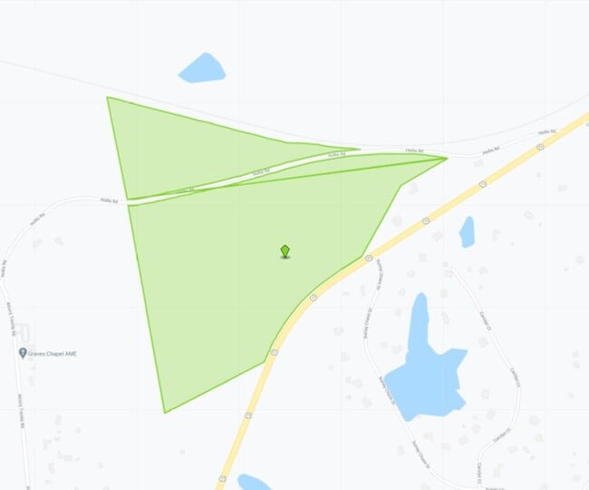
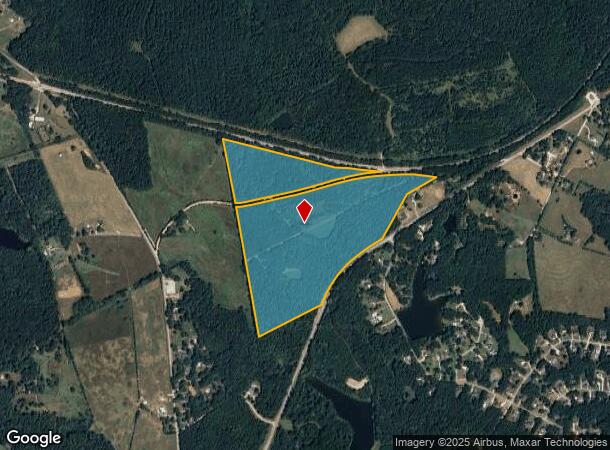
Hollis Rd
Atlanta-Sandy Springs-Roswell, GA
Hwy 11 @ Walton Co
0123000000001000
79.519AC HOLLIS RD
Residentialacreage
Newton
X
Georgia
13297C0240F
136
2024
79.52 AC
2024
Newton County
110802
Atlanta
DEMOGRAPHICS near Hollis Rd
1 Mile
3 Mile
5 Mile
2024 Total Population
304
7,387
15,383
2029 Population
340
8,436
17,456
Pop Growth 2024-2029
+ 11.84%
+ 14.20%
+ 13.48%
Average Age
42
40
40
2024 Total Households
108
2,600
5,456
HH Growth 2024-2029
+ 12.04%
+ 14.58%
+ 13.82%
Median Household Inc
$113,499
$94,887
$92,434
Avg Household Size
2.80
2.80
2.80
2024 Avg HH Vehicles
2.00
3.00
2.00
Median Home Value
$290,243
$282,991
$290,734
Median Year Built
1995
1996
1996
Nearby Places
Map Layers
Map Styles
 Street
 Aerial
- Restaurants
- Banks
- Shops
- Fitness
- Groceries
Nearby Properties
Address
Land Use
TOTAL SIZE
Lot Size
Zoning
Address
Land Use
TOTAL SIZE
Lot Size
Zoning
846,540 SF
102.62 AC
MCMUBP
Address
Land Use
TOTAL SIZE
Lot Size
Zoning
90,861 SF
1.24 AC
Address
Land Use
TOTAL SIZE
Lot Size
Zoning
96,984 SF
2.09 AC
OI
Address
Land Use
TOTAL SIZE
Lot Size
Zoning
4,239 SF
453.35 AC
A1
Address
Land Use
TOTAL SIZE
Lot Size
Zoning
576.11 AC
Address
Land Use
TOTAL SIZE
Lot Size
Zoning
117,648 SF
27.53 AC
OI
Address
Land Use
TOTAL SIZE
Lot Size
Zoning
90,861 SF
96.67 AC
E6
Address
Land Use
TOTAL SIZE
Lot Size
Zoning
56,497 SF
9.32 AC
OI
Address
Land Use
TOTAL SIZE
Lot Size
Zoning
2,023 SF
19.54 AC
OI
Address
Land Use
TOTAL SIZE
Lot Size
Zoning
20,607 SF
20.09 AC
A
Address
Land Use
TOTAL SIZE
Lot Size
Zoning
226.27 AC
Address
Land Use
TOTAL SIZE
Lot Size
Zoning
10,868 SF
28.61 AC
OI
Address
Land Use
TOTAL SIZE
Lot Size
Zoning
716.34 AC
A
Address
Land Use
TOTAL SIZE
Lot Size
Zoning
31,995 SF
9.05 AC
GC
Address
Land Use
TOTAL SIZE
Lot Size
Zoning
13,420 SF
20 AC
E2
Address
Land Use
TOTAL SIZE
Lot Size
Zoning
46.12 AC
CH
Address
Land Use
TOTAL SIZE
Lot Size
Zoning
223.99 AC
A
Address
Land Use
TOTAL SIZE
Lot Size
Zoning
9,100 SF
1.96 AC
Address
Land Use
TOTAL SIZE
Lot Size
Zoning
10,548 SF
4.16 AC
GC WP2
Address
Land Use
TOTAL SIZE
Lot Size
Zoning
143.25 AC
AG
Address
Land Use
TOTAL SIZE
Lot Size
Zoning
168.51 AC
Address
Land Use
TOTAL SIZE
Lot Size
Zoning
25 AC
OI
Address
Land Use
TOTAL SIZE
Lot Size
Zoning
119.41 AC
A
Address
Land Use
TOTAL SIZE
Lot Size
Zoning
188.50 AC
AR
Address
Land Use
TOTAL SIZE
Lot Size
Zoning
42.72 AC
Address
Land Use
TOTAL SIZE
Lot Size
Zoning
1,612 SF
8.25 AC
RMD
Address
Land Use
TOTAL SIZE
Lot Size
Zoning
11,112 SF
1.73 AC
OI
Address
Land Use
TOTAL SIZE
Lot Size
Zoning
10,666 SF
7 AC
AR
Address
Land Use
TOTAL SIZE
Lot Size
Zoning
358.80 AC
A
Address
Land Use
TOTAL SIZE
Lot Size
Zoning
20,880 SF
5.60 AC
C1
The World's #1 Commercial Real Estate Marketplace
Connect with us
© 2025 CoStar Group
The information above has been obtained from sources believed reliable. While we do not doubt its accuracy we have not verified it and make no guarantee, warranty or representation about it. It is your responsibility to independently confirm its accuracy and completeness. Any projections, opinions, assumptions, or estimates used are for example only and do not represent the current or future performance of the property. The value of this transaction to you depends on tax and other factors which should be evaluated by your tax, financial, and legal advisors. You and your advisors should conduct a careful, independent investigation of the property to determine to your satisfaction the suitability of the property for your needs.