Property Record
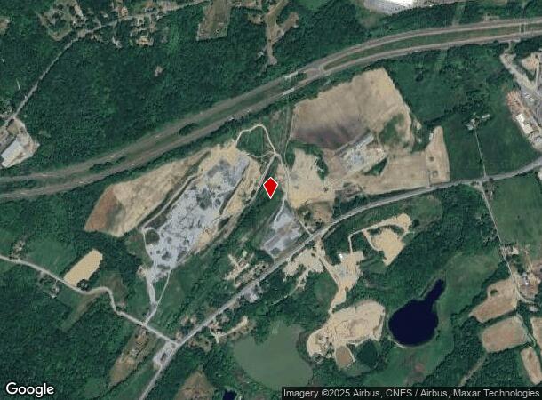
Hoops Rd, Wawayanda, NY
NEARBY LISTINGS FOR SALE OR LEASE
Property Detail
Hoops Rd
Kiryas Joel-Poughkeepsie-Newburgh, NY
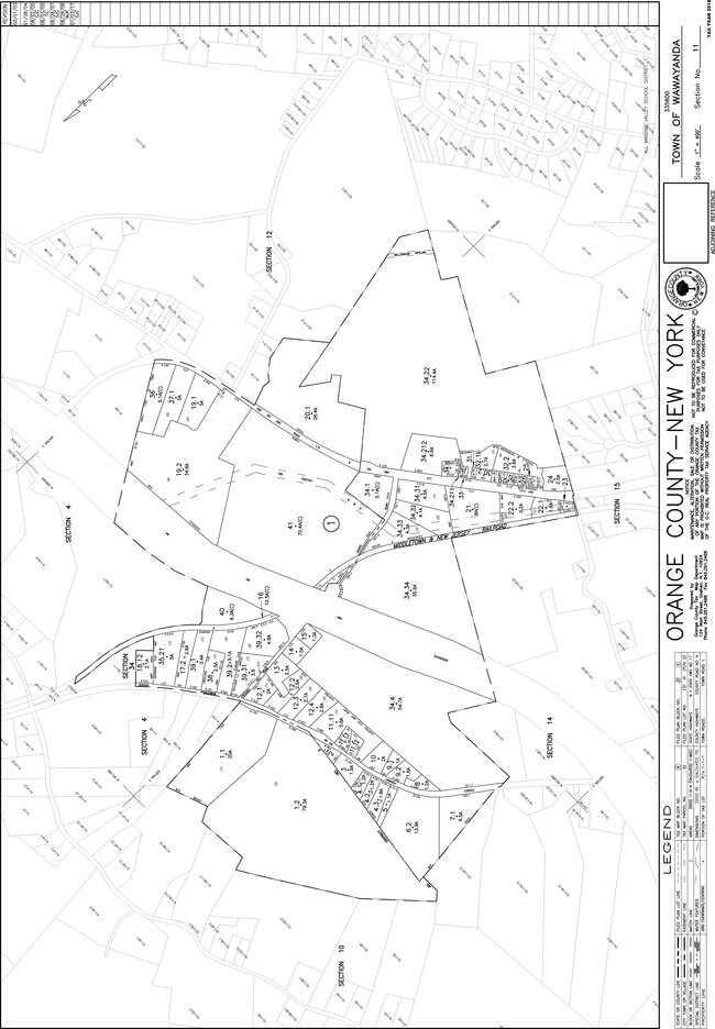
LT 3 MAP 9615
335600-011-000-0001-034.330-0000
Orange
Commercialacreage
New York
X
34.33
36071C0265E
4.30 AC
2024
Middletown
2024
Northern New Jersey
011801
DEMOGRAPHICS near Hoops Rd
1 Mile
3 Mile
5 Mile
2024 Total Population
405
15,417
51,348
2029 Population
408
15,748
52,223
Pop Growth 2024-2029
+ 0.74%
+ 2.15%
+ 1.70%
Average Age
41
40
39
2024 Total Households
139
5,920
18,650
HH Growth 2024-2029
+ 0.72%
+ 2.40%
+ 1.89%
Median Household Inc
$115,131
$77,149
$77,145
Avg Household Size
2.90
2.60
2.60
2024 Avg HH Vehicles
2.00
2.00
2.00
Median Home Value
$326,744
$282,355
$269,223
Median Year Built
1978
1987
1971
Nearby Places
Map Layers
Map Styles
 Street
 Aerial
- Restaurants
- Banks
- Shops
- Fitness
- Groceries
PUBLIC TRANSPORTATION
COMMUTER RAIL
Middletown New York (Bergen County/Port Jervis Line - NJ Transit Commuter Rail (NJ Transit), Main/Port Jervis Line - NJ Transit Commuter Rail (NJ Transit))
DRIVE
WALK
Distance
Middletown New York (Bergen County/Port Jervis Line - NJ Transit Commuter Rail (NJ Transit), Main/Port Jervis Line - NJ Transit Commuter Rail (NJ Transit))
15 min
8.5 mi
AIRPORT
New York Stewart International
DRIVE
WALK
Distance
New York Stewart International
32 min
23.7 mi
Freight Ports
Port Newark Container Terminal
DRIVE
WALK
Distance
Port Newark Container Terminal
96 min
72.3 mi
Nearby Properties
Address
Land Use
TOTAL SIZE
Lot Size
Zoning
Address
Land Use
TOTAL SIZE
Lot Size
Zoning
72.50 AC
MC 1
Address
Land Use
TOTAL SIZE
Lot Size
Zoning
499,762 SF
67.30 AC
SR-MC1
Address
Land Use
TOTAL SIZE
Lot Size
Zoning
40.40 AC
I-2
Address
Land Use
TOTAL SIZE
Lot Size
Zoning
240,800 SF
29.50 AC
MC 1
Address
Land Use
TOTAL SIZE
Lot Size
Zoning
29,950 SF
3 AC
TC-1
Address
Land Use
TOTAL SIZE
Lot Size
Zoning
26,659 SF
15.80 AC
MC 2
Address
Land Use
TOTAL SIZE
Lot Size
Zoning
17.60 AC
R-1
Address
Land Use
TOTAL SIZE
Lot Size
Zoning
50,700 SF
7.70 AC
TC-1
Address
Land Use
TOTAL SIZE
Lot Size
Zoning
26,156 SF
0.01 AC
TC-1
Address
Land Use
TOTAL SIZE
Lot Size
Zoning
5,832 SF
2.30 AC
TC-1
Address
Land Use
TOTAL SIZE
Lot Size
Zoning
4 AC
TC2
Address
Land Use
TOTAL SIZE
Lot Size
Zoning
7 AC
C-3
Address
Land Use
TOTAL SIZE
Lot Size
Zoning
60,321 SF
10.70 AC
TC2
Address
Land Use
TOTAL SIZE
Lot Size
Zoning
6.80 AC
MC 1
Address
Land Use
TOTAL SIZE
Lot Size
Zoning
41,728 SF
5 AC
TC-1
Address
Land Use
TOTAL SIZE
Lot Size
Zoning
726 SF
40.30 AC
C-3
Address
Land Use
TOTAL SIZE
Lot Size
Zoning
4.90 AC
Address
Land Use
TOTAL SIZE
Lot Size
Zoning
12.60 AC
R-1
Address
Land Use
TOTAL SIZE
Lot Size
Zoning
207.90 AC
04200
Address
Land Use
TOTAL SIZE
Lot Size
Zoning
24.90 AC
R-AH
Address
Land Use
TOTAL SIZE
Lot Size
Zoning
11.50 AC
SR-3B
Address
Land Use
TOTAL SIZE
Lot Size
Zoning
24.70 AC
MC 1
Address
Land Use
TOTAL SIZE
Lot Size
Zoning
22,144 SF
5.60 AC
MC 2
Address
Land Use
TOTAL SIZE
Lot Size
Zoning
19.20 AC
C-3
Address
Land Use
TOTAL SIZE
Lot Size
Zoning
7,161 SF
2.40 AC
SR-MC2
Address
Land Use
TOTAL SIZE
Lot Size
Zoning
104,070 SF
10 AC
MC 1
Address
Land Use
TOTAL SIZE
Lot Size
Zoning
19,555 SF
10.10 AC
MC 1
Address
Land Use
TOTAL SIZE
Lot Size
Zoning
21.20 AC
Address
Land Use
TOTAL SIZE
Lot Size
Zoning
21,134 SF
4.70 AC
TC-1
Address
Land Use
TOTAL SIZE
Lot Size
Zoning
26,800 SF
3.50 AC
The World's #1 Commercial Real Estate Marketplace
Connect with us
© 2026 CoStar Group
The information above has been obtained from sources believed reliable. While we do not doubt its accuracy we have not verified it and make no guarantee, warranty or representation about it. It is your responsibility to independently confirm its accuracy and completeness. Any projections, opinions, assumptions, or estimates used are for example only and do not represent the current or future performance of the property. The value of this transaction to you depends on tax and other factors which should be evaluated by your tax, financial, and legal advisors. You and your advisors should conduct a careful, independent investigation of the property to determine to your satisfaction the suitability of the property for your needs.